Krzywiń
Krzywiń [ˈkʂɨvʲiɲ] (German: Kriewen) is a town in west-central Poland in the Kościan County, Greater Poland Voivodeship, located at the Obra canal.
Krzywiń | |
|---|---|
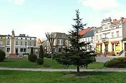 Market square | |
 Flag  Coat of arms | |
 Krzywiń | |
| Coordinates: 51°58′N 16°49′E | |
| Country | |
| Voivodeship | Greater Poland |
| County | Kościan |
| Gmina | Krzywiń |
| Area | |
| • Total | 1.67 km2 (0.64 sq mi) |
| Highest elevation | 75 m (246 ft) |
| Lowest elevation | 67 m (220 ft) |
| Population (2006) | |
| • Total | 1,547 |
| • Density | 930/km2 (2,400/sq mi) |
| Time zone | UTC+1 (CET) |
| • Summer (DST) | UTC+2 (CEST) |
| Postal code | 64-010 |
| Vehicle registration | PKS |
| Voivodeship roads | |
History
_ID_652226.jpg.webp)
Krzywiń was first referred to in scripts as Crivin in 1181. But it was not until 1237 that the area's reputation grew as a prominent marketplace. It was then that it was referred to as a town. Incorporation of the town followed in 1257.[1] It was a private church town, administratively located in the Kościan County in the Poznań Voivodeship in the Greater Poland Province of the Kingdom of Poland.[2]
During the German occupation of Poland (World War II), local prominent Poles were among the victims of a massacre of Poles from the county, perpetrated by the Germans in November 1939 in the forest near Kościan as part of the Intelligenzaktion.[3] In 1943, the German security police carried out expulsions of Poles, who were then placed in a transit camp in Poznań, and afterwards deported to the General Government in the more eastern part of German-occupied Poland, while their houses and farms were handed over to German colonists as part of the Lebensraum policy.[4]
Education
There are three schools in Krzywiń. There is a primary school, a junior high school and a high school.
Notable people
- Krystyn Szelejewski (d. 1457/1459), Polish nobleman and castellan
References
- From the Polish "Nazwy Miast Wielkopolski" (English: Names of Towns in Greater Poland) by Zofia and Karol Zierhofferowie pp. 82-83; Publisher: "Wydawnictwo Poznańskie" (English: Publishing House of Poznań); Year of Publication: 1987; ISBN 83-210-0680-9
- Atlas historyczny Polski. Wielkopolska w drugiej połowie XVI wieku. Część I. Mapy, plany (in Polish). Warszawa: Instytut Historii Polskiej Akademii Nauk. 2017. p. 1a.
- Wardzyńska, Maria (2009). Był rok 1939. Operacja niemieckiej policji bezpieczeństwa w Polsce. Intelligenzaktion (in Polish). Warszawa: IPN. pp. 200–201.
- Wardzyńska, Maria (2017). Wysiedlenia ludności polskiej z okupowanych ziem polskich włączonych do III Rzeszy w latach 1939-1945 (in Polish). Warszawa: IPN. p. 367. ISBN 978-83-8098-174-4.
- "Promień Krzywiń - strona klubu" (in Polish). Retrieved 8 January 2023.