Kulja, Western Australia
Kulja is a small town in the Wheatbelt region of Western Australia. The town is situated along the Bonnie Rock to Burakin Road.
| Kulja Western Australia | |
|---|---|
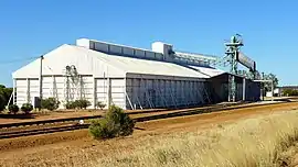
 Kulja grain receival point, 2014 | |
 Kulja | |
| Coordinates | 30°30′S 117°19′E |
| Population | 20 (SAL 2021)[1] |
| Established | 1928 |
| Postcode(s) | 6470 |
| Elevation | 321 m (1,053 ft) |
| Area | 526.7 km2 (203.4 sq mi) |
| Location |
|
| LGA(s) | Shire of Koorda |
| State electorate(s) | Central Wheatbelt |
| Federal division(s) | Durack |
The area was charted in 1908 and the Indigenous Australian name of a local soak was recorded as Kulja. The townsite was originally established in the late 1920s as part of a railway siding on the Ejanding North Railway line. The townsite was gazetted in 1928 once a large enough local population had settled in the area.[2]
The surrounding areas produce wheat and other cereal crops. The town is a receiving site for Cooperative Bulk Handling.[3]
History
Kulja had a post office between 1928 and 1973. There was also a Kulja Railway Construction post office between 1929 and 1931.[4]
In 1932 the Wheat Pool of Western Australia announced that the town would have two grain elevators, each fitted with an engine, installed at the railway siding.[5]
References
- Australian Bureau of Statistics (28 June 2022). "Kulja (Suburb and Locality)". Australian Census 2021 QuickStats. Retrieved 28 June 2022.
- "History of country town names – K". Western Australian Land Information Authority. Archived from the original on 14 March 2022. Retrieved 7 October 2008.
- "CBH receiving sites" (PDF). 2011. Archived from the original (PDF) on 18 March 2012. Retrieved 1 April 2013.
- Dzelme, John (1976) Place and Date Stamps of Western Australia, p. 103 Perth, W.A: published by the author
- "Country elevators". The West Australian. Perth. 6 July 1932. p. 10. Retrieved 6 April 2013 – via National Library of Australia.