Kumarkhali Upazila
Kumarkhali (Bengali: কুমারখালি) is an upazila of Kushtia District in the Division of Khulna, Bangladesh.[1] It is famous for the Shelaidaha area, where the poet Rabindranath Tagore spent a considerable time of his youth.
Kumarkhali
কুমারখালি (কুষ্টিয়া) | |
|---|---|
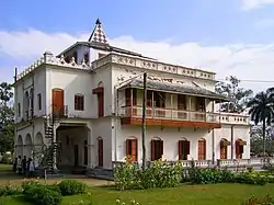 Shilaidaha Kuthibari, the famous residence of Rabindranath Tagore, is located at Kumarkhali | |
 Kumarkhali Location in Bangladesh | |
| Coordinates: 23°51′15.12″N 89°14′30.12″E | |
| Country | |
| Division | Khulna Division |
| District | Kushtia District |
| Capital | Kumarkhali |
| Area | |
| • Total | 265.89 km2 (102.66 sq mi) |
| Population (2011) | |
| • Total | 328,457 |
| • Density | 1,200/km2 (3,200/sq mi) |
| Time zone | UTC+6 (BST) |
| Website | Official map of Kumarkhali |
Geography
Kumarkhali is located at 23.8542°N 89.2417°E. It has 48387 households and total area 265.89 km2.
It is bounded by Pabna Sadar Upazila and the Padma River on the north; Shailkupa Upazila on the south; Khoksa Upazila on the east; and Kushtia Sadar Upazila on the west.[1]
Demographics
According to 2011 Bangladesh census, Kumarkhali had a population of 328,457. Males constituted 49.77% of the population and females 50.23%. Muslims formed 96.757% of the population, Hindus 3.297%, Christians 0.005% and others 0.003%. Kumarkhali had a literacy rate of 45.3% for the population 7 years and above.[2]
At the 1991 Bangladesh census Kumarkhali had a population of 269,008, of whom 133,845 were aged 18 or older. Males constituted 51.77% of the population, and females made up 48.23%. Kumarkhali had an average literacy rate of 24.9% (7+ years), against the national average of 32.4%.[3]
Administration
Kumarkhali Thana was formed in 1855 consisting of 13 parganas and it was upgraded into a Sub Division of Pabna District in 1857. In 1871 Kumarkhali Sub Division was abolished and it was included in Kushtia Sub Division under Nadia District. Kumarkhali Thana was turned into an upazila in 1983. Besides, Kumarkhali Municipality, formed in 1869, is one of the earliest municipalities of the undivided Bengal.[1]
The upazila is divided into Kumarkhali Municipality and 11 union parishads: Bagulat, Chandpur, Chapra, Jadu Boyra, Jagannathpur, Kaya, Nandalalpur, Panti, Sadaki, Sadipur, and Shelaidaha. The union parishads are subdivided into 187 mauzas and 201 villages.[4]
Kumarkhali Municipality is subdivided into 9 wards and 17 mahallas.[4]
References
- Shiek Md Badrul Alam Tipu (2012), "Kumarkhali Upazila", in Sirajul Islam and Ahmed A. Jamal (ed.), Banglapedia: National Encyclopedia of Bangladesh (Second ed.), Asiatic Society of Bangladesh
- "Bangladesh Population and Housing Census 2011: Zila Report – Kushtia" (PDF). Table P01 : Household and Population by Sex and Residence, Table P05 : Population by Religion, Age group and Residence, Table P09 : Literacy of Population 7 Years & Above by Religion, Sex and Residence. Bangladesh Bureau of Statistics (BBS), Ministry of Planning, Government of the People’s Republic of Bangladesh. Retrieved 9 December 2018.
- "Population Census Wing, BBS". Archived from the original on 2005-03-27. Retrieved November 10, 2006.
- "District Statistics 2011: Kushtia" (PDF). Bangladesh Bureau of Statistics. Archived from the original (PDF) on 13 November 2014. Retrieved 14 July 2014.
| Upazila/Thana: | ||
|---|---|---|
