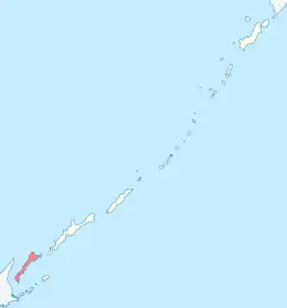
Kunashir
Kunashir Island (Russian: Кунаши́р, romanized: Kunashír; Japanese: 国後島, romanized: Kunashiri-tō; Ainu: クナシㇼ, romanized: Kuna=sir), possibly meaning Black Island or Grass Island in Ainu, is the southernmost island of the Kuril Islands archipelago. The island has been under Russian administration since the end of World War II, when Soviet forces took possession of the Kurils. It is claimed by Japan (see Kuril Islands dispute).
| Disputed island Native name: Ainu: クナシㇼ | |
|---|---|
 Kunashir is in the middle | |
 Location of Kunashir Island | |
 Kunashir Island  Kunashir Island | |
| Other names | Kazakh: Kün Ashyr; Japanese: 国後島 |
| Geography | |
| Location | Sea of Okhotsk |
| Coordinates | 44°07′N 145°51′E |
| Archipelago | Kuril Islands |
| Area | 1,490 km2 (580 sq mi) |
| Length | 123 km (76.4 mi) |
| Width | 4 km (2.5 mi) to 30 km (19 mi) |
| Highest elevation | 1,819 m (5968 ft) |
| Highest point | Chacha |
| Administration | |
| Federal subject | Sakhalin Oblast |
| District | Yuzhno-Kurilsky |
| Claimed by | |
| Prefecture | Hokkaido |
| Subprefecture | Nemuro |
| Demographics | |
| Population | approx. 7000 (2007) |
Geography
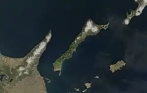
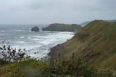
Kunashir lies between the straits of Kunashir Island, Catherine, Izmena, and South Kuril. Kunashir Island is visible from the nearby Japanese island of Hokkaido, from which it is separated by the Nemuro Strait.
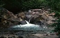
Kunashir Island is formed by four volcanoes which were separate islands but have since joined together by low-lying areas with lakes and hot springs. All these volcanoes are still active: Tyatya (1,819 m (5,968 ft)), Smirnov, Mendeleev (Rausu-yama), and Golovnin (Tomari-yama).[1] The island is made up of volcanic and crystalline rocks.
_Relief_Map%252C_SRTM-1.jpg.webp) Relief map
Relief map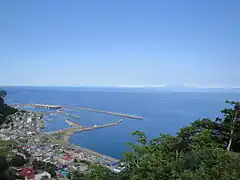 View of Kunashir from the Rausu Kunashiri Observatory Deck
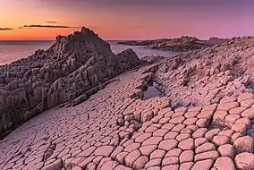 Cape Stolbchaty on the western side of the island
Environment
The climate is humid continental with very heavy precipitation especially in the autumn and a strong seasonal lag with maximum temperatures in August and September. The vegetation mostly consists of spruce, pine, fir, and mixed deciduous forests with lianas and Kuril bamboo underbrush. The mountains are covered with birch and Siberian Dwarf Pine scrub, herbaceous flowers or bare rocks. Tree cores of century-old oaks (Quercus crispula) were found in July 2001 on Kunashiri Island.[2]
Important Bird Area
Kunashir, along with the neighbouring Lesser Kuril Chain of smaller islands, has been recognised as an Important Bird Area (IBA) by BirdLife International as the island supports populations of various threatened bird species, including many waterbirds, seabirds and waders.[3]
History
The original inhabitants of the island—as with most of Hokkaido and the Kurils—were the Ainu. Europeans are first recorded visiting this part of the Kurils in 1643[4] when the Castricum under Maarten Gerritsz Vries was exploring Hokkaido and the surrounding area for the Dutch East India Company (VOC).[5] Vries's account of the area was incredibly garbled[6]—including a fictitious continental extension dubbed Company Land—but while his imaginary Staten Island is usually connected to Iturup,[7] its placement on most maps of the period more closely resembles the location of Kunashir. Vitus Bering's lieutenant Martin Spanberg mapped the actual locations of the Kurils including Kunashir in a series of voyages in 1738, 1739, and 1742 but Company Land and Staten Island continued to appear in European maps decades afterwards.[8]
The Japanese expanded north to Kunashir in the 18th century, with the Matsumae clan establishing a fishery and trading site called Kunashiri-basho (国後場所) in 1754.[9] Its headquarters was located in Tomari (present-day Golovnino) and administered Kunashir, Iturup, and Urup.
In 1789 Kunashir Island was one of the settings of the Menashi-Kunashiri Battle in which native Ainu revolted against Yamato Japanese tradespeople and colonists.
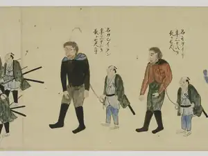
Russian navigator Vasily Golovnin attempted to map and explore the island in 1811, but was apprehended by Japanese authorities and spent two years in prison.
On September 1, 1945, or one day before the surrender documents of World War II were signed on September 2, 1945, in accordance with understandings reached at the Yalta Conference, the Soviet Union invaded and occupied the Kuril Islands. This occurred after the Soviet Union renounced the Soviet–Japanese Neutrality Pact signed in April 1941, and declared war on Japan on August 9, 1945 (formally, the pact itself remained in effect until April 13, 1946). Although Japan agreed after deliberations to cede its claims to "the Kurile Islands" as part of the Treaty of San Francisco in 1951, the Japanese government has claimed since the mid-1950s that the southern islands were not part of the ceded Kuril Islands.
Settlements
The largest settlement on Kunashir Island is Yuzhno-Kurilsk, administrative center of Yuzhno-Kurilsky District.
Economy
The primary economic activity is fishing. The island has a port next to Yuzhno-Kurilsk. Kunashir Island enjoys a Mendeleevskaya GeoPP geothermal power plant with the capacity of 1.8 MW.[10]
Transport
The island is served by Mendeleyevo Airport.
Population
After the 1994 earthquake, about one-third of Kunashir Island's population left and did not return. By 2002, the island's population was approximately 7,800. The total population of the disputed Kuril islands at that time was approximately 17,000.[11]
See also
References
Notes
- Volcanoes
- Jacoby, G.; Solomina, O.; Frank, D.; Eremenko, N.; D'Arrigo, R. (2004). "Kunashir (Kuriles) Oak 400-year reconstruction of temperature and relation to the Pacific Decadal Oscillation". Palaeogeography, Palaeoclimatology, Palaeoecology. 209 (1–4): 303–311. Bibcode:2004PPP...209..303J. doi:10.1016/j.palaeo.2004.02.015.
- "Lesser Kuril Ridge and Kunashir Island". BirdLife Data Zone. BirdLife International. 2021. Retrieved 7 February 2021.
- "THE 17TH AND 18TH CENTURIES". Archived from the original on 2008-03-25. Retrieved 2008-03-25.
- Saint-Martin, Louis Vivien de; Rousselet, Louis (1895). Nouveau dictionnaire de géographie universelle (in French). Hatchette et cie. p. 444–445.
- De Saint-Martin, Vivien; et al., eds. (1895), "Yèso", Nouveau Dictionnaire de Géographie Universelle (in French), vol. 7, Paris: Librairie Hachette & Co., p. 441–445.
- Heawood, Edward (1912). A history of geographical discovery in the seventeenth and eighteenth centuries. Cambridge: Cambridge University Press. pp. 87.
- Wroth, Lawrence C. (1944), "The Early Cartography of the Pacific", The Papers of the Bibliographical Society of America, vol. 38, Chicago: University of Chicago Press, pp. 87–231 & 233–268, JSTOR 24301919.
- 戸祭由美夫『絵図に見る幕末の北辺防備:五稜郭と城郭・陣屋・台場』古今書院、2018年、71頁(Tomatsuri Yumio, Japanese Military Architectures around the Coast of Yezo Province in the Nineteenth Century, (Tokyo: Kokon Shoin Publishers Ltd), p.71. ISBN 9784772220248)
- "2007 Survey of Energy Resources" (PDF). World Energy Council 2007. 2007. Archived from the original (PDF) on 9 April 2011. Retrieved 23 January 2011.
- Yuzhno-Kurilsk Journal; Between Russia and Japan, a Pacific Tug of War — The New York Times, 2002
General references
- Geographic data at the Wayback Machine (archived December 23, 2010)
- Flights to Kunashir Island banned