Ashwell, Queensland
Ashwell is a rural locality in the City of Ipswich, Queensland, Australia.[2] In the 2016 census, Ashwell had a population of 85 people.[1]
| Ashwell Ipswich, Queensland | |||||||||||||||
|---|---|---|---|---|---|---|---|---|---|---|---|---|---|---|---|
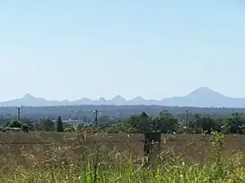
 Ashwell landscape, 2010 | |||||||||||||||
 Ashwell | |||||||||||||||
| Coordinates | 27.625°S 152.5558°E | ||||||||||||||
| Population | 85 (2016 census)[1] | ||||||||||||||
| • Density | 11.33/km2 (29.4/sq mi) | ||||||||||||||
| Postcode(s) | 4340 | ||||||||||||||
| Area | 7.5 km2 (2.9 sq mi) | ||||||||||||||
| Time zone | AEST (UTC+10:00) | ||||||||||||||
| Location |
| ||||||||||||||
| LGA(s) | City of Ipswich | ||||||||||||||
| State electorate(s) | Ipswich West | ||||||||||||||
| Federal division(s) | Blair | ||||||||||||||
| |||||||||||||||
Geography
Kunkala is a neighbourhood in the north of the locality (27.6095°S 152.5618°E) near the Kunkala railway station (27.6090°S 152.5618°E) on the now-closed Marburg branch railway line.[3][4]
History
The origin of the name Ashwell is from a town in the United Kingdom by the name of Ashwell. Walter Loveday and Henry Stevens provided an acre each of land for a school in this district to be named Ashwell after Walter Loveday's farm titled Ashwell which he named after Ashwell, United Kingdom.[2]
Ashwell State School opened on 8 November 1887.[5]
The name Kunkala may be an Aboriginal word for running fresh water.[3]
At the 2011 census Ashwell and nearby Lanefield recorded a population of 234.[6]
In the 2016 census, Ashwell had a population of 85 people.[1]
Education
Ashwell State School is a government primary (Prep-6) school for boys and girls at 35 Reinke Road (27.6294°S 152.5565°E).[7][8] In 2018, the school had an enrolment of 58 students with 4 teachers and 8 non-teaching staff (4 full-time equivalent).[9]
There is no secondary school in Ashwell. The nearest secondary school is Rosewood State High School in neighbouring Rosewood to the south-east.[10]
References
- Australian Bureau of Statistics (27 June 2017). "Ashwell (SSC)". 2016 Census QuickStats. Retrieved 20 October 2018.
- "Ashwell – locality in City of Ipswich (entry 45023)". Queensland Place Names. Queensland Government. Retrieved 18 September 2020.
- "Kunkala – locality unbounded in City of Ipswich (entry 18622)". Queensland Place Names. Queensland Government. Retrieved 18 September 2020.
- "Rail journey lines up a tour mecca". The Queensland Times. 18 April 2014. Archived from the original on 29 October 2014. Retrieved 28 October 2014.
- Queensland Family History Society (2010), Queensland schools past and present (Version 1.01 ed.), Queensland Family History Society, ISBN 978-1-921171-26-0
- Australian Bureau of Statistics (31 October 2012). "Ashwell (State Suburb)". 2011 Census QuickStats. Retrieved 1 July 2015.
- "State and non-state school details". Queensland Government. 9 July 2018. Archived from the original on 21 November 2018. Retrieved 21 November 2018.
- "Ashwell State School". Archived from the original on 5 April 2021. Retrieved 26 March 2021.
- "ACARA School Profile 2018". Australian Curriculum, Assessment and Reporting Authority. Archived from the original on 27 August 2020. Retrieved 28 January 2020.
- "Queensland Globe". State of Queensland. Retrieved 17 October 2020.