Kure Beach, North Carolina
Kure Beach (/ˈkjʊəri/ KURE-ee)[6] is a town in New Hanover County, North Carolina, United States, approximately 15 miles south of Wilmington. It is part of the Wilmington Metropolitan Statistical Area. The population was 2,012 at the 2010 census. It is found on Pleasure Island directly south of the Wilmington Beach annex of Carolina Beach and just north of Fort Fisher. The town is less than 1 square mile (2.6 km2) in area, stretching along about 3.5 miles (5.6 km) of coastline along Pleasure Island, and a maximum width of less than 0.5 miles (0.80 km), in most places only a few hundred yard/meters wide.
Kure Beach, North Carolina | |
|---|---|
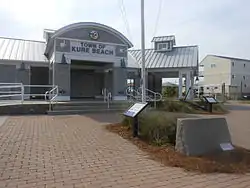
 Town of Kure Beach | |
 Flag  Seal | |
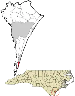
 Location in New Hanover County and the state of North Carolina. | |
| Coordinates: 33°59′56″N 77°54′28″W | |
| Country | United States |
| State | North Carolina |
| County | New Hanover |
| Government | |
| • Mayor | Craig Bloszinsky[1] |
| Area | |
| • Total | 0.88 sq mi (2.29 km2) |
| • Land | 0.88 sq mi (2.28 km2) |
| • Water | 0.00 sq mi (0.01 km2) |
| Elevation | 23 ft (7 m) |
| Population (2020) | |
| • Total | 2,191 |
| • Density | 2,489.77/sq mi (961.63/km2) |
| Time zone | UTC-5 (Eastern (EST)) |
| • Summer (DST) | UTC-4 (EDT) |
| ZIP code | 28449 |
| Area codes | 910, 472 |
| FIPS code | 37-36220[5] |
| GNIS feature ID | 2405961[4] |
| Website | www |
History
A post office called Kure Beach has been in operation since 1942.[7] The town was named for a family of settlers.[8]
The Kure Beach Fishing Pier is one of the oldest on the Atlantic Coast. The original pier was built in 1923 and has been rebuilt and restored several times since then due to wear and tear over the years.
On the night of July 24–25, 1943, a German U-boat fired at least three shells to attack the Ethyl-Dow Chemical Company plant at Kure's Beach (post-war: Kure Beach), but instead hit the Cape Fear River. The plant was the only one on the East Coast producing bromine from seawater for use in aviation gasoline. [9] Other historians dispute whether the attack actually occurred, and there is no corroborating physical evidence or logs from the German Navy.[10]
Demographics
| Census | Pop. | Note | %± |
|---|---|---|---|
| 1950 | 228 | — | |
| 1960 | 293 | 28.5% | |
| 1970 | 394 | 34.5% | |
| 1980 | 611 | 55.1% | |
| 1990 | 619 | 1.3% | |
| 2000 | 1,507 | 143.5% | |
| 2010 | 2,012 | 33.5% | |
| 2020 | 2,191 | 8.9% | |
| 2021 (est.) | 2,148 | −2.0% | |
| U.S. Decennial Census[11] | |||
2020 census
| Race | Number | Percentage |
|---|---|---|
| White (non-Hispanic) | 2,024 | 92.38% |
| Black or African American (non-Hispanic) | 10 | 0.46% |
| Native American | 6 | 0.27% |
| Asian | 18 | 0.82% |
| Pacific Islander | 2 | 0.09% |
| Other/Mixed | 94 | 4.29% |
| Hispanic or Latino | 37 | 1.69% |
As of the 2020 United States census, there were 2,191 people, 951 households, and 601 families residing in the town.
2000 census
As of the census[5] of 2000, there were 1,507 people, 723 households, and 495 families residing in the town. The population density was 1,931.6 inhabitants per square mile (745.8/km2). There were 1,560 housing units at an average density of 1,999.6 per square mile (772.0/km2). The racial makeup of the town was 98.74% White, 0.07% African American, 0.13% Native American, 0.07% Asian, 0.07% from other races, and 0.93% from two or more races. Hispanic or Latino of any race were 0.93% of the population.
There were 723 households, out of which 15.1% had children under 18 living with them, 61.3% were married couples living together, 5.1% had a female householder with no husband present, and 31.5% were non-families. 26.7% of all households were made up of individuals, and 8.7% had someone living alone 65 years of age or older. The average household size was 2.08, and the average family size was 2.48.
The population was spread out in the town, with 12.0% under the age of 18, 4.5% from 18 to 24, 22.5% from 25 to 44, 42.3% from 45 to 64, and 18.7% who were 65 years of age or older. The median age was 50 years. For every 100 females, there were 94.2 males. For every 100 females age 18 and over, there were 91.6 males.
The median income for a household in the town was $47,143, and the median income for a family was $55,875. Males had a median income of $32,708 versus $30,735 for females. The per capita income for the town was $26,759. About 4.1% of families and 5.7% of the population were below the poverty line, including 8.3% of those under age 18 and 3.5% of those age 65 or over.
New Hanover County School System
In this area of North Carolina elementary school children will be zoned for Carolina Beach Elementary School, middle school children zoned for Murray Middle School, and zoned for high school, Ashley High School or an early college high school including:
Isaac Bear Early College High School (UNCW)
Wilmington Early College High School (CFCC)
References
- "Elected Officials". New Hanover County Board of Elections. Retrieved April 23, 2022.
- "US Gazetteer files: 2010, 2000, and 1990". United States Census Bureau. February 12, 2011. Retrieved April 23, 2011.
- "ArcGIS REST Services Directory". United States Census Bureau. Retrieved September 20, 2022.
- U.S. Geological Survey Geographic Names Information System: Kure Beach, North Carolina
- "U.S. Census website". United States Census Bureau. Retrieved January 31, 2008.
- Ben Steelman (March 6, 2009). "Why do they call it Kure Beach?". Star News Online. Retrieved November 29, 2011.
- "New Hanover County". Jim Forte Postal History. Retrieved November 1, 2015.
- Proffitt, Martie (April 17, 1983). "Local history offers tasty tidbits". Star-News. pp. 8C. Retrieved November 1, 2015.
- Jones, Wilbur D Jr. The Journey Continues: The World War II Home Front. p. xxiv,64.
- Hanc, John (August 2, 2017). "Did a Nazi Submarine Attack a Chemical Plant in North Carolina?". Smithsonian. Retrieved August 3, 2017.
- "Census of Population and Housing". Census.gov. Retrieved June 4, 2015.
- "Explore Census Data". data.census.gov. Retrieved December 24, 2021.
