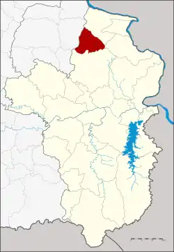
Kut Khaopun district
Kut Khaopun (Thai: กุดข้าวปุ้น, pronounced [kùt kʰâːw.pûn]) is a district (amphoe) in the northern part of Ubon Ratchathani province, northeastern Thailand.
Kut Khaopun
กุดข้าวปุ้น | |
|---|---|
 District location in Ubon Ratchathani province | |
| Coordinates: 15°47′30″N 104°59′48″E | |
| Country | Thailand |
| Province | Ubon Ratchathani |
| Seat | Khaopun |
| Area | |
| • Total | 320.0 km2 (123.6 sq mi) |
| Population (2005) | |
| • Total | 39,824 |
| • Density | 124.5/km2 (322/sq mi) |
| Time zone | UTC+7 (ICT) |
| Postal code | 34270 |
| Geocode | 3412 |
History
The minor district (king amphoe) Kut Khaopun was created on 12 July 1971, when the four tambons Khaopun, Ka Bin, Kaeng Kheng, and Non Sawang were split off from Trakan Phuet Phon district.[1] It was upgraded to a full district on 25 March 1979.[2]
Geography
Neighboring districts are (from the northeast clockwise) Khemarat, Pho Sai, Trakan Phuet Phon of Ubon Ratchathani Province and Pathum Ratchawongsa of Amnat Charoen province.
Administration
The district is divided into five sub-districts (tambons), which are further subdivided into 73 villages (mubans). Kut Khaopun is a township (thesaban tambon) which covers parts of tambon Khaopun. There are a further five tambon administrative organizations (TAO).
| No. | Name | Thai name | Villages | Pop. | |
|---|---|---|---|---|---|
| 1. | Khaopun | ข้าวปุ้น | 15 | 9,426 | |
| 2. | Non Sawang | โนนสวาง | 20 | 10,503 | |
| 3. | Kaeng Kheng | แก่งเค็ง | 13 | 7,401 | |
| 4. | Ka Bin | กาบิน | 12 | 5,253 | |
| 5. | Nong Than Nam | หนองทันน้ำ | 13 | 7,241 |
References
- ประกาศกระทรวงมหาดไทย เรื่อง แบ่งท้องที่อำเภอตระการพืชผล ตั้งเป็นกิ่งอำเภอกุดข้าวปุ้น จังหวัดอุบลราชธานี (PDF). Royal Gazette (in Thai). 88 (79 ง): 2084. July 27, 1971. Archived from the original (PDF) on May 10, 2012.
- พระราชกฤษฎีกาตั้งอำเภอหนองกุงศรี อำเภอไทรงาม อำเภอบ้านฝาง อำเภออุบลรัตน์ อำเภอเวียงชัย อำเภอดอยเต่า อำเภอนิคมคำสร้อย อำเภอนาหว้า อำเภอเสิงสาง อำเภอศรีสาคร อำเภอบึงสามพัน อำเภอนาดูน อำเภอค้อวัง อำเภอโพธิ์ชัย อำเภอเมืองสรวง อำเภอปลวกแดง อำเภอยางชุมน้อย อำเภอกาบเชิง อำเภอสุวรรณคูหา และอำเภอกุดข้าวปุ้น พ.ศ. ๒๕๒๒ (PDF). Royal Gazette (in Thai). 96 (42 ก Special): 19–24. March 25, 1979. Archived from the original (PDF) on September 30, 2007.