La Chapelle-sur-Furieuse
La Chapelle-sur-Furieuse (French pronunciation: [la ʃapɛl syʁ fyʁjøz]) is a commune in the Jura department in Bourgogne-Franche-Comté in eastern France.[3]
La Chapelle-sur-Furieuse | |
|---|---|
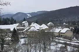 A general view of La Chapelle-sur-Furieuse | |
 Coat of arms | |
Location of La Chapelle-sur-Furieuse | |
 La Chapelle-sur-Furieuse  La Chapelle-sur-Furieuse | |
| Coordinates: 46°59′55″N 5°51′29″E | |
| Country | France |
| Region | Bourgogne-Franche-Comté |
| Department | Jura |
| Arrondissement | Dole |
| Canton | Arbois |
| Government | |
| • Mayor (2020–2026) | Bernard Brunel[1] |
| Area 1 | 9.03 km2 (3.49 sq mi) |
| Population | 306 |
| • Density | 34/km2 (88/sq mi) |
| Time zone | UTC+01:00 (CET) |
| • Summer (DST) | UTC+02:00 (CEST) |
| INSEE/Postal code | 39103 /39110 |
| Elevation | 250–550 m (820–1,800 ft) |
| 1 French Land Register data, which excludes lakes, ponds, glaciers > 1 km2 (0.386 sq mi or 247 acres) and river estuaries. | |
Population
|
|
See also
References
- "Répertoire national des élus: les maires". data.gouv.fr, Plateforme ouverte des données publiques françaises (in French). 2 December 2020.
- "Populations légales 2020". The National Institute of Statistics and Economic Studies. 29 December 2022.
- INSEE commune file
Wikimedia Commons has media related to La Chapelle-sur-Furieuse.
This article is issued from Wikipedia. The text is licensed under Creative Commons - Attribution - Sharealike. Additional terms may apply for the media files.