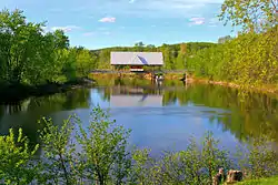
La Conception
La Conception is a village and municipality in the Laurentides region of Quebec, Canada, part of the Les Laurentides Regional County Municipality.
La Conception | |
|---|---|
 Village of La Conception | |
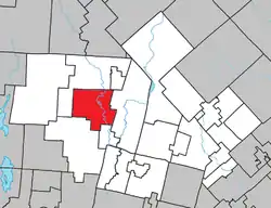 Location within Les Laurentides RCM. | |
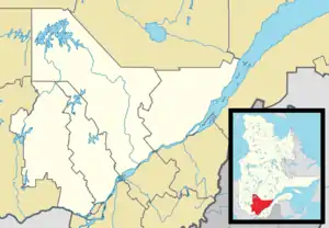 La Conception Location in central Quebec. | |
| Coordinates: 46°09′N 74°42′W[1] | |
| Country | |
| Province | |
| Region | Laurentides |
| RCM | Les Laurentides |
| Constituted | January 1, 1882 |
| Government | |
| • Mayor | Maurice Plouffe |
| • Federal riding | Laurentides—Labelle |
| • Prov. riding | Labelle |
| Area | |
| • Total | 140.50 km2 (54.25 sq mi) |
| • Land | 127.37 km2 (49.18 sq mi) |
| Population (2021)[3] | |
| • Total | 1,527 |
| • Density | 9.9/km2 (26/sq mi) |
| • Pop 2016-2021 | |
| • Dwellings | 1,229 |
| Time zone | UTC−5 (EST) |
| • Summer (DST) | UTC−4 (EDT) |
| Postal code(s) | |
| Area code | 819 |
| Highways | |
| Website | www.municipalite .laconception.qc.ca |
Demographics
Population trend:[4]
- Population in 2021: 1527 (2016 to 2021 population change: 14.2%)
- Population in 2016: 1337
- Population in 2011: 1287
- Population in 2006: 1283
- Population in 2001: 1050
- Population in 1996: 917
- Population in 1991: 695
Private dwellings occupied by usual residents: 743 (total dwellings: 1229)
Mother tongue:
- English as first language: 6.5%
- French as first language: 89.9%
- English and French as first language: 0.7%
- Other as first language: 2.3%
Geography
La Conception is located in the Laurentides region of Quebec, which is known for its beautiful landscapes, including mountains, forests, and lakes. It is situated near Mont-Tremblant, a popular tourist destination known for its ski resort and outdoor recreational activities.
Education
Sainte Agathe Academy (of the Sir Wilfrid Laurier School Board) in Sainte-Agathe-des-Monts serves English-speaking students in this community for both elementary and secondary levels.[5]
La Conception, being part of Quebec, follows the provincial education system of Quebec. This system includes both French-language and English-language schools.
In Quebec, primary education typically covers grades 1 to 6, while secondary education covers grades 7 to 11. These schools are generally publicly funded and administered by school boards.
References
- "Reference number 33244 in Banque de noms de lieux du Québec". toponymie.gouv.qc.ca (in French). Commission de toponymie du Québec.
- "Geographic code 78115 in the official Répertoire des municipalités". www.mamh.gouv.qc.ca (in French). Ministère des Affaires municipales et de l'Habitation.
- "Census Profile, 2021 Census, Statistics Canada - Validation Error".
- Statistics Canada: 1996, 2001, 2006, 2011, 2016, 2021 census
- "About Us." Saint Agathe Academy. Retrieved on September 4, 2017. See Elementary zone map Archived 2017-09-04 at the Wayback Machine and Secondary zone map Archived 2017-09-04 at the Wayback Machine - Note that all areas covered in the elementary map are also covered in the secondary one.
Places adjacent to La Conception | ||||||||||||||||
|---|---|---|---|---|---|---|---|---|---|---|---|---|---|---|---|---|
| ||||||||||||||||
| Cities/towns | |
|---|---|
| Municipalities | |
| Townships | |
| Parishes | |
| Villages | |
| |