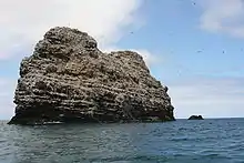
La Pèrouse Pinnacle
La Pèrouse Pinnacle is a basalt rock formation in the French Frigate Shoals, Hawaii.[1]
Geography
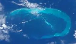
It stands at the heart of the French Frigate Shoals, reaching 122 ft (37 m) above the surrounding lagoon.[2][3]
Unlike the predominantly coral line origin of other islets in the atoll, La Pèrouse Pinnacle's basalt composition is unusual. Covering an area of approximately 39,580 sq ft (3,677 m2), it extends 751 ft (229 m) in the northwest–southeast direction, with a maximum width of 160 ft (50 m). It creates a habitat for marine organisms, especially algae, contributing to the area's biodiversity. The central location of the Pinnacle adds to its prominence, and can be seen up to 8 mi (13 km) away.[4][5]
History
In 1786, the French frigates Astrolabe and Boussole, led by Comte de La Pérouse, narrowly avoided disaster at French Frigate Shoals. The Boussole mistook the pinnacle for the Astrolabe, but a last-minute course correction saved them. The pinnacle was named in honor of Comte de La Pérouse, preserving this event in maritime history.[2][6][7]
In the 19th century, the whaling ship Rebecca, in a moonlit night, mistook La Pèrouse Pinnacle for a sailing vessel. Attempts to signal went unanswered, and they ran aground on the reef, however the ship and the crew did survive.[8]
See also
- Ball's Pyramid (Another rocky pinnacle in the Pacific)
External links
References
- "La Perouse Pinnacle". Geographic Names Information System. United States Geological Survey, United States Department of the Interior. Retrieved October 11, 2023.
- "Papahānaumokuākea Marine National Monument". www.papahanaumokuakea.gov. Retrieved 2023-09-07.
- Stanley, David (1985). South Pacific Handbook. Moon publications. p. 549. ISBN 9780918373052.
- "La Perouse Pinnacle". memim.com. Retrieved 2023-09-07.
- United States Hydrographic Office (1940). Sailing Directions for the Pacific Islands (eastern Groups). Vol. II. U.S. Government Printing Office. p. 444.
- Bryan, Edwin Horace, ed. (1978). The Northwestern Hawaiian Islands: An Annotated Bibliography. U.S. Fish and Wildlife Service. pp. 11–12.
- Rauzon, Mark J. (2000). Isles of Refuge: Wildlife and History of the Northwestern Hawaiian Islands. University of Hawaii Press. p. 54. ISBN 9780824846268.
- Imray, James Frederick (1870). North Pacific Pilot: The seaman's guide to the islands of the North Pacific by W.H. Rosser. James Imray & Son.
 | ||