La Paz Valley, Arizona
La Paz Valley is a census-designated place (CDP) in La Paz County, Arizona, United States. Its population was 368 as of the 2020 census. The community is in western La Paz County and is bordered to the north by the town of Quartzsite. To the south it is bordered by Yuma County.
La Paz Valley, Arizona | |
|---|---|
Census-designated place (CDP) | |
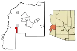 Location of La Paz Valley in La Paz County, Arizona | |
 La Paz Valley  La Paz Valley | |
| Coordinates: 33°33′30″N 114°14′36″W | |
| Country | United States |
| State | Arizona |
| County | La Paz |
| Area | |
| • Total | 29.37 sq mi (76.06 km2) |
| • Land | 29.37 sq mi (76.06 km2) |
| • Water | 0.00 sq mi (0.00 km2) |
| Elevation | 1,027 ft (313 m) |
| Population (2020) | |
| • Total | 368 |
| • Density | 12.53/sq mi (4.84/km2) |
| Time zone | UTC-7 (Mountain (MST)) |
| ZIP code | 85346[2] |
| Area code | 928 |
| GNIS feature ID | 2582813 |
| FIPS code | 04-40160 |
U.S. Route 95 forms the eastern border of the CDP and runs north into Quartzsite and south 76 miles (122 km) to Yuma. The Town of Quartzsite operates demand response buses under the name Camel Express that provide weekday service to Quartzsite and La Paz Valley.[3]
References
- "2020 U.S. Gazetteer Files". United States Census Bureau. Retrieved October 29, 2021.
- "La Paz Valley AZ ZIP Code". zipdatamaps.com. 2023. Retrieved May 3, 2023.
- "Public Transportation". Retrieved October 10, 2016.
- "Census of Population and Housing". Census.gov. Retrieved June 4, 2016.
External links
Municipalities and communities of La Paz County, Arizona, United States | ||
|---|---|---|
| Towns | 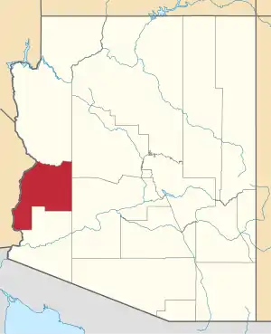 | |
| CDPs | ||
| Populated places | ||
| Indian reservations | ||
| Ghost towns | ||
This article is issued from Wikipedia. The text is licensed under Creative Commons - Attribution - Sharealike. Additional terms may apply for the media files.