Whanganui Central
Whanganui Central is the central business district and central suburb of Whanganui, in the Whanganui District and Manawatū-Whanganui region of New Zealand's North Island.
Whanganui Central | |
|---|---|
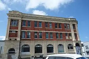 Whanganui Chronicle building | |
| Coordinates: 39.930355°S 175.047644°E | |
| Country | New Zealand |
| City | Whanganui |
| Local authority | Whanganui District Council |
| Area | |
| • Land | 418 ha (1,033 acres) |
| Population (June 2022)[2] | |
| • Total | 4,440 |
| St Johns Hill | Aramoho | Whanganui East |
| College Estate |
|
Bastia Hill |
| Gonville | Putiki | Durie Hill |
Demographics
Whanganui Central covers 4.18 km2 (1.61 sq mi)[1] and had an estimated population of 4,440 as of June 2022,[2] with a population density of 1,062 people per km2.
| Year | Pop. | ±% p.a. |
|---|---|---|
| 2006 | 4,131 | — |
| 2013 | 3,786 | −1.24% |
| 2018 | 4,203 | +2.11% |
| Source: [3] | ||
Whanganui Central had a population of 4,203 at the 2018 New Zealand census, an increase of 417 people (11.0%) since the 2013 census, and an increase of 72 people (1.7%) since the 2006 census. There were 1,878 households, comprising 1,980 males and 2,220 females, giving a sex ratio of 0.89 males per female, with 705 people (16.8%) aged under 15 years, 843 (20.1%) aged 15 to 29, 1,803 (42.9%) aged 30 to 64, and 855 (20.3%) aged 65 or older.
Ethnicities were 72.1% European/Pākehā, 28.6% Māori, 5.1% Pacific peoples, 7.3% Asian, and 2.1% other ethnicities. People may identify with more than one ethnicity.
The percentage of people born overseas was 15.8, compared with 27.1% nationally.
Although some people chose not to answer the census's question about religious affiliation, 46.1% had no religion, 35.3% were Christian, 3.4% had Māori religious beliefs, 1.3% were Hindu, 0.4% were Muslim, 0.6% were Buddhist and 3.0% had other religions.
Of those at least 15 years old, 528 (15.1%) people had a bachelor's or higher degree, and 840 (24.0%) people had no formal qualifications. 186 people (5.3%) earned over $70,000 compared to 17.2% nationally. The employment status of those at least 15 was that 1,266 (36.2%) people were employed full-time, 507 (14.5%) were part-time, and 267 (7.6%) were unemployed.[3]
| Name | Area (km2) | Population | Density (per km2) | Households | Median age | Median income |
|---|---|---|---|---|---|---|
| Laird Park | 1.11 | 2,247 | 2,204 | 906 | 38.8 years | $22,000[4] |
| Cornmarket | 0.63 | 1,350 | 2,142 | 705 | 49.4 years | $21,700[5] |
| Whanganui Central | 2.44 | 606 | 248 | 267 | 39.5 years | $26,000[6] |
| New Zealand | 37.4 years | $31,800 |
Features
Whanganui Regional Museum opened in 1892 and contains a range of displays about Whangaui's Māori and European settlement.[7][8]
Sarjeant Gallery opened in 1919.[9][10]
Education
Keith Street School is a co-educational state primary school,[11] with a roll of 143 as of April 2023.[12]
References
- "ArcGIS Web Application". statsnz.maps.arcgis.com. Retrieved 6 April 2023.
- "Population estimate tables - NZ.Stat". Statistics New Zealand. Retrieved 25 October 2022.
- "Statistical area 1 dataset for 2018 Census". Statistics New Zealand. March 2020. Laird Park (224800), Cornmarket (225400) and Whanganui Central (225700).
- 2018 Census place summary: Laird Park
- 2018 Census place summary: Cornmarket
- 2018 Census place summary: Whanganui Central
- "Whanganui Regional Museum". Whanganui Regional Museum.
- "Whanganui Regional Museum on NZ Museums". nzmuseums.co.nz. Te Papa.
- "Sarjeant Gallery". Sarjeant Gallery.
- "Sarjeant Gallery on NZ Museums". nzmuseums.co.nz. Te Papa.
- "Ministry of Education School Profile". educationcounts.govt.nz. Ministry of Education.
- "Education Review Office Report". ero.govt.nz. Education Review Office.