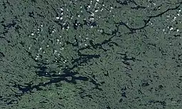
Lake Minto
Lake Minto (Inuktitut: Qasigialik, "where there are spotted seals") is a lake on western Ungava Peninsula, Nunavik, Quebec, Canada. It has a total surface area of 761 square kilometres (294 sq mi) and a net area of 703 square kilometres (271 sq mi).[3]
| Lake Minto | |
|---|---|
 Lake Minto | |
 | |
| Location | Baie-d'Hudson, Kativik, Quebec |
| Coordinates | 57°13′07″N 75°00′45″W |
| Type | Oligotrophic |
| Primary inflows | Charpentier River and other rivers |
| Primary outflows | Leaf River |
| Basin countries | Canada |
| Max. length | 81 km (50 mi) [1] |
| Max. width | 22 km (14 mi) [1] |
| Surface area | 761 km2 (294 sq mi) [2] |
| Surface elevation | 168 m (551 ft) [2] |
It was named by Canadian explorer and geologist Albert Peter Low in 1898 after Gilbert Elliot-Murray-Kynynmound, 4th Earl of Minto, who was Governor General of Canada at that time.[1]
It is only some 60 kilometres (37 mi) east of Hudson Bay in a valley between several rows of hills, but Lake Minto's outlet, the Leaf River, flows north-east for about 265 kilometres (165 mi) to Ungava Bay. As such, it is used by canoeists especially when crossing Ungava from west to east.[1][4][5]
It is considered one of the most beautiful lakes in northern Quebec.[1]
References
- "Lac Minto" (in French). Commission de toponymie du Québec. Retrieved 2010-12-13.
- Statistics Canada > summary tables > Principal lakes, elevation and area, by provinces and territories Archived 2011-07-06 at the Wayback Machine
- Natural Resources Canada, Atlas of Canada - Lakes Archived 2007-04-10 at the Wayback Machine
- "Northern Ungava Canoe Expedition". Archived from the original on 2008-07-19. Retrieved 2011-05-21. Northern Ungava Canoe Expedition
- http://www.nrsweb.com/services/newsletter/2007/rtnStory_0207b.asp Crossing the Ungava