Langdon, New Hampshire
Langdon is a town in Sullivan County, New Hampshire, United States. The population was 651 at the 2020 census.[2]
Langdon, New Hampshire | |
|---|---|
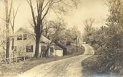
 Street scene, c. 1909 | |
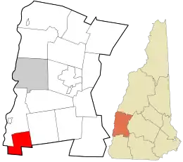
 Location in Sullivan County and the state of New Hampshire. | |
| Coordinates: 43°10′00″N 72°22′49″W | |
| Country | United States |
| State | New Hampshire |
| County | Sullivan |
| Incorporated | 1787 |
| Government | |
| • Selectboard |
|
| Area | |
| • Total | 16.3 sq mi (42.3 km2) |
| • Land | 16.3 sq mi (42.1 km2) |
| • Water | 0.08 sq mi (0.2 km2) 0.45% |
| Elevation | 676 ft (206 m) |
| Population (2020) | |
| • Total | 651 |
| • Density | 40/sq mi (15.5/km2) |
| Time zone | UTC-5 (Eastern) |
| • Summer (DST) | UTC-4 (Eastern) |
| ZIP code | 03602 |
| Area code | 603 |
| FIPS code | 33-40900 |
| GNIS feature ID | 0873642 |
| Website | langdonnh |
History
First settled in 1773 by Seth Walker, Langdon was incorporated on January 11, 1787, when it was named after Governor John Langdon.[3] The town is home to the Prentiss Bridge, the shortest covered bridge in New Hampshire. Built across Great Brook in 1874, the lattice truss span has a length of 34 feet 6 inches (10.52 m).
Geography
According to the United States Census Bureau, the town has a total area of 16.3 square miles (42.3 km2), of which 0.1 square miles (0.2 km2) are water, comprising 0.45% of the town.[1] Drained by the Cold River and its tributary Great Brook, Langdon lies within the Connecticut River watershed.[4] The highest point in town is the summit of Holden Hill, at 1,348 feet (411 m) above sea level.
Adjacent municipalities
- Charlestown, New Hampshire (north)
- Acworth, New Hampshire (east)
- Alstead, New Hampshire (southeast)
- Walpole, New Hampshire (southwest)
Demographics
| Census | Pop. | Note | %± |
|---|---|---|---|
| 1790 | 244 | — | |
| 1800 | 484 | 98.4% | |
| 1810 | 632 | 30.6% | |
| 1820 | 654 | 3.5% | |
| 1830 | 667 | 2.0% | |
| 1840 | 615 | −7.8% | |
| 1850 | 575 | −6.5% | |
| 1860 | 478 | −16.9% | |
| 1870 | 411 | −14.0% | |
| 1880 | 364 | −11.4% | |
| 1890 | 305 | −16.2% | |
| 1900 | 339 | 11.1% | |
| 1910 | 340 | 0.3% | |
| 1920 | 279 | −17.9% | |
| 1930 | 267 | −4.3% | |
| 1940 | 276 | 3.4% | |
| 1950 | 378 | 37.0% | |
| 1960 | 338 | −10.6% | |
| 1970 | 337 | −0.3% | |
| 1980 | 437 | 29.7% | |
| 1990 | 580 | 32.7% | |
| 2000 | 586 | 1.0% | |
| 2010 | 688 | 17.4% | |
| 2020 | 651 | −5.4% | |
| U.S. Decennial Census[5] | |||
As of the census[6] of 2000, there were 586 people, 237 households, and 174 families residing in the town. The population density was 36.0 inhabitants per square mile (13.9/km2). There were 269 housing units at an average density of 16.5 per square mile (6.4/km2). The racial makeup of the town was 99.66% White, 0.17% from other races, and 0.17% from two or more races. Hispanic or Latino of any race were 0.17% of the population.
There were 237 households, out of which 29.5% had children under the age of 18 living with them, 65.4% were married couples living together, 5.5% had a female householder with no husband present, and 26.2% were non-families. 21.1% of all households were made up of individuals, and 8.4% had someone living alone who was 65 years of age or older. The average household size was 2.47 and the average family size was 2.85.
In the town, the population was spread out, with 21.3% under the age of 18, 5.3% from 18 to 24, 30.2% from 25 to 44, 31.2% from 45 to 64, and 11.9% who were 65 years of age or older. The median age was 41 years. For every 100 females, there were 113.1 males. For every 100 females age 18 and over, there were 105.8 males.
The median income for a household in the town was $42,083, and the median income for a family was $43,125. Males had a median income of $33,750 versus $24,444 for females. The per capita income for the town was $24,572. About 3.3% of families and 3.8% of the population were below the poverty line, including none of those under age 18 and 12.3% of those age 65 or over.
Site of interest
References
- "2021 U.S. Gazetteer Files – New Hampshire". United States Census Bureau. Retrieved January 7, 2022.
- "Census - Geography Profile: Langdon town, Sullivan County, New Hampshire". Retrieved December 25, 2021.
- Gannett, Henry (1905). The Origin of Certain Place Names in the United States. U.S. Government Printing Office. p. 181.
- Foster, Debra H.; Batorfalvy, Tatianna N.; Medalie, Laura (1995). Water Use in New Hampshire: An Activities Guide for Teachers. U.S. Department of the Interior and U.S. Geological Survey.
- "Census of Population and Housing". Census.gov. Retrieved June 4, 2016.
- "U.S. Census website". United States Census Bureau. Retrieved January 31, 2008.
