Latulipe-et-Gaboury
Latulipe-et-Gaboury is a united township municipality in northwestern Quebec, Canada, in the Témiscamingue Regional County Municipality. The only other remaining united township municipality in Quebec is Stoneham-et-Tewkesbury.
Latulipe-et-Gaboury | |
|---|---|
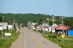 Latulipe | |
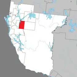 Location within Témiscamingue RCM. | |
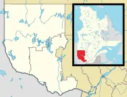 Latulipe-et-Gaboury Location in western Quebec. | |
| Coordinates: 47°25′38″N 79°01′56″W[1] | |
| Country | Canada |
| Province | Quebec |
| Region | Abitibi-Témiscamingue |
| RCM | Témiscamingue |
| Settled | 1909 |
| Constituted | November 18, 1924 |
| Named for | Élie-Anicet Latulipe, Tancrède-Charles Gaboury[1] |
| Government | |
| • Mayor | Michel Duval |
| • Federal riding | Abitibi—Témiscamingue |
| • Prov. riding | Rouyn-Noranda–Témiscamingue |
| Area | |
| • Total | 298.30 km2 (115.17 sq mi) |
| • Land | 270.11 km2 (104.29 sq mi) |
| Population (2021)[3] | |
| • Total | 320 |
| • Density | 1.2/km2 (3/sq mi) |
| • Pop (2016–21) | |
| • Dwellings | 225 |
| Time zone | UTC−05:00 (EST) |
| • Summer (DST) | UTC−04:00 (EDT) |
| Postal code(s) | |
| Area code | 819 |
| Website | www |
Demographics
In the 2021 Census of Population conducted by Statistics Canada, Latulipe-et-Gaboury had a population of 320 living in 159 of its 225 total private dwellings, a change of 8.5% from its 2016 population of 295. With a land area of 270.11 km2 (104.29 sq mi), it had a population density of 1.2/km2 (3.1/sq mi) in 2021.[4]
Population trend:[5]
- Population in 2021: 320 (2016 to 2021 population change: 8.5%)
- Population in 2016: 295
- Population in 2011: 304
- Population in 2006: 333
- Population in 2001: 357
- Population in 1996: 351
- Population in 1991: 366
Private dwellings occupied by usual residents: 159 (total dwellings: 225)
Mother tongue:[6]
- English as first language: 0%
- French as first language: 100%
- English and French as first language: 0%
- Other as first language: 0%
References
- "Reference number 34616 in Banque de noms de lieux du Québec". toponymie.gouv.qc.ca (in French). Commission de toponymie du Québec.
- "Latulipe-et-Gaboury". Répertoire des municipalités (in French). Ministère des Affaires municipales, des Régions et de l'Occupation du territoire. Archived from the original on 2012-06-01. Retrieved 2010-12-31.
- "Latulipe-et-Gaboury census profile". 2021 Census data. Statistics Canada. Retrieved 2022-05-05.
- "Population and dwelling counts: Canada, provinces and territories, and census subdivisions (municipalities), Quebec". Statistics Canada. February 9, 2022. Retrieved August 28, 2022.
- Statistics Canada: 1996, 2001, 2006, 2011, 2016, 2021 census
- "Latulipe-et-Gaboury community profile". 2006 Census data. Statistics Canada. Retrieved 2010-12-31.
Adjacent Municipal Subdivisions | ||||||||||||||||
|---|---|---|---|---|---|---|---|---|---|---|---|---|---|---|---|---|
| ||||||||||||||||
| Cities | |
|---|---|
| Municipalities | |
| Townships |
|
| Parishes | |
| Unorganized territories | |
| |
This article is issued from Wikipedia. The text is licensed under Creative Commons - Attribution - Sharealike. Additional terms may apply for the media files.