Lemland
Lemland is a municipality of Åland, an autonomous territory of Finland.
Lemland | |
|---|---|
Municipality | |
| Lemlands kommun | |
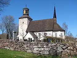 The medieval parish church in Lemland. | |
 Coat of arms | |
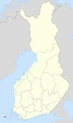 Location of Lemland in Finland | |
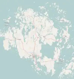 Lemland Location in Åland | |
| Coordinates: 60°04.2′N 020°05.2′E | |
| Country | |
| Region | Åland |
| Sub-region | Åland Countryside sub-region |
| Government | |
| • Municipal manager | Mikael Smeds |
| Area (2018-01-01)[1] | |
| • Total | 965.30 km2 (372.70 sq mi) |
| • Land | 113.08 km2 (43.66 sq mi) |
| • Water | 852.23 km2 (329.05 sq mi) |
| • Rank | 293rd largest in Finland |
| Population (2023-10-26)[2] | |
| • Total | 2,148 |
| • Rank | 251st largest in Finland |
| • Density | 19/km2 (50/sq mi) |
| Population by native language | |
| • Swedish | 91.5% (official) |
| • Finnish | 3.4% |
| • Others | 5.1% |
| Population by age | |
| • 0 to 14 | 20.6% |
| • 15 to 64 | 61.2% |
| • 65 or older | 18.2% |
| Time zone | UTC+02:00 (EET) |
| • Summer (DST) | UTC+03:00 (EEST) |
| Website | www.lemland.ax |
The municipality has a population of 2,148 (26 October 2023)[2] and covers an area of 965.30 square kilometres (372.70 sq mi) of which 852.23 km2 (329.05 sq mi) is water.[1] The population density is 19 inhabitants per square kilometre (49/sq mi).
The municipality is unilingually Swedish.
The Lemström channel divides Lemland from its neighboring municipality, Jomala. It was widened by Russian POWs in 1882.
History
The church in Lemland was built in the 13th century and has wall paintings from the 14th century. The church is dedicated to Bridget of Sweden.
During the Finnish War in 1808 the Swedish king Gustav IV Adolf had his headquarters in the Lemland parsonage.[5]
Gallery
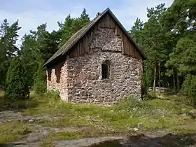 St. Olof's Chapel in Lemland.
 The Lemström Canal.
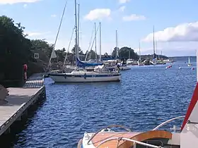 The Rödhamn Harbour.
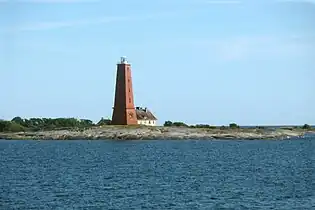 The Lågskär Lighthouse.
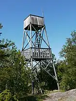 The observation tower of Herrö.
Climate
Lemland has a humid continental climate (Dfb) with oceanic (Cfb) influence
| Climate data for Lemland Nyhamn (1991–2020 normals, extremes 1959- present) | |||||||||||||
|---|---|---|---|---|---|---|---|---|---|---|---|---|---|
| Month | Jan | Feb | Mar | Apr | May | Jun | Jul | Aug | Sep | Oct | Nov | Dec | Year |
| Record high °C (°F) | 8.5 (47.3) |
7.8 (46.0) |
11.1 (52.0) |
16.4 (61.5) |
23.5 (74.3) |
26.5 (79.7) |
28.7 (83.7) |
26.9 (80.4) |
21.4 (70.5) |
16.4 (61.5) |
12.7 (54.9) |
9.3 (48.7) |
28.7 (83.7) |
| Daily mean °C (°F) | 0.2 (32.4) |
−1.1 (30.0) |
0.4 (32.7) |
3.2 (37.8) |
7.7 (45.9) |
12.4 (54.3) |
16.7 (62.1) |
16.9 (62.4) |
13.1 (55.6) |
8.3 (46.9) |
4.6 (40.3) |
2.1 (35.8) |
7.0 (44.6) |
| Record low °C (°F) | −29.2 (−20.6) |
−24.9 (−12.8) |
−17.3 (0.9) |
−12.8 (9.0) |
−1.2 (29.8) |
2.2 (36.0) |
6.4 (43.5) |
4.0 (39.2) |
2.0 (35.6) |
−3.0 (26.6) |
−8.5 (16.7) |
−23.0 (−9.4) |
−29.2 (−20.6) |
| Source 1: FMI climatological normals for Finland 1991-2020[6] | |||||||||||||
| Source 2: Record highs and lows 1959- present[7] | |||||||||||||
References
- "Area of Finnish Municipalities 1.1.2018" (PDF). National Land Survey of Finland. Retrieved 30 January 2018.
- "Preliminary population statistics 2023, September". StatFin. Statistics Finland. Retrieved 26 October 2023.
- "Demographic Structure by area as of 31 December 2022". Statistics Finland's PX-Web databases. Statistics Finland. Retrieved 6 September 2023.
- "Population according to age (1-year) and sex by area and the regional division of each statistical reference year, 2003–2020". StatFin. Statistics Finland. Retrieved 2 May 2021.
- Torsten Hellberg (ed): Åland – mer än öar, p.19. Stockholm 2001.
- "FMI normals 1991-2020". fmi.fi. Retrieved 23 April 2023.
- "FMI open data". FMI. Retrieved 21 May 2023.
External links
![]() Media related to Lemland at Wikimedia Commons
Media related to Lemland at Wikimedia Commons
- Municipality of Lemland – Official website
Places adjacent to Lemland | ||||||||||||||||
|---|---|---|---|---|---|---|---|---|---|---|---|---|---|---|---|---|
| ||||||||||||||||
