Les Maskoutains Regional County Municipality
Les Maskoutains is a regional county municipality in the Montérégie region in southwestern Quebec, Canada. Its seat is in Saint-Hyacinthe.
Les Maskoutains | |
|---|---|
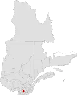 Location in province of Quebec. | |
| Coordinates: 45°37′N 72°57′W[1] | |
| Country | |
| Province | |
| Region | Montérégie |
| Effective | January 1, 1982 |
| County seat | Saint-Hyacinthe |
| Government | |
| • Type | Prefecture |
| • Prefect | Mme Francine Morin |
| Area | |
| • Total | 1,313.90 km2 (507.30 sq mi) |
| • Land | 1,302.90 km2 (503.05 sq mi) |
| Population (2016)[3] | |
| • Total | 87,099 |
| • Density | 66.9/km2 (173/sq mi) |
| • Change 2011-2016 | |
| • Dwellings | 40,244 |
| Time zone | UTC−5 (EST) |
| • Summer (DST) | UTC−4 (EDT) |
| Area code(s) | 450 and 579 |
| Website | www |
The name comes from Algonquin word maskutew meaning "bear plain" in plular.
Subdivisions
There are 17 subdivisions within the RCM:[2]
|
|
|
|
Demographics
Population
Canada census – Les Maskoutains community profile
| 2021 | 2016 | 2011 | |
|---|---|---|---|
| Population | 89,432 (+2.7% from 2016) | 87,099 (+3.4% from 2011) | 84,248 (+4.4% from 2006) |
| Land area | 1,302.15 km2 (502.76 sq mi) | 1,302.90 km2 (503.05 sq mi) | 1,301.16 km2 (502.38 sq mi) |
| Population density | 68.7/km2 (178/sq mi) | 66.9/km2 (173/sq mi) | 64.7/km2 (168/sq mi) |
| Median age | 44 (M: 42.8, F: 45.2) | 43.7 (M: 41.9, F: 45.5) | 42.8 (M: 41.2, F: 44.4) |
| Private dwellings | 39,930 (total) | 40,244 (total) | 38,387 (total) |
| Median household income | $55,917 | $50,253 |
|
|
| |||||||||||||||||||||||||||
| [9][3] | |||||||||||||||||||||||||||||
Language
| Canada Census Mother Tongue - Les Maskoutains Regional County Municipality, Quebec[9] | ||||||||||||||||||
|---|---|---|---|---|---|---|---|---|---|---|---|---|---|---|---|---|---|---|
| Census | Total | French |
English |
French & English |
Other | |||||||||||||
| Year | Responses | Count | Trend | Pop % | Count | Trend | Pop % | Count | Trend | Pop % | Count | Trend | Pop % | |||||
2016 |
86,010 |
81,730 | 95.0% | 665 | 0.8% | 330 | 0.4% | 3,285 | 2.50% | |||||||||
2011 |
82,625 |
79,610 | 96.35% | 645 | 0.78% | 305 | 0.37% | 2,065 | 2.50% | |||||||||
2006 |
78,930 |
76,425 | 96.83% | 555 | 0.70% | 180 | 0.23% | 1,770 | 2.24% | |||||||||
2001 |
77,025 |
75,395 | 97.88% | 540 | 0.70% | 205 | 0.27% | 885 | 1.15% | |||||||||
1996 |
77,385 |
75,735 | n/a | 97.87% | 760 | n/a | 0.98% | 170 | n/a | 0.22% | 720 | n/a | 0.93% | |||||
Transportation
References
- "Reference number 141068 in Banque de noms de lieux du Québec". toponymie.gouv.qc.ca (in French). Commission de toponymie du Québec.
- "Geographic code 540 in the official Répertoire des municipalités". www.mamh.gouv.qc.ca (in French). Ministère des Affaires municipales et de l'Habitation.
- "Census Profile, 2016 Census: Les Maskoutains, Municipalité régionale de comté [Census division], Quebec". Statistics Canada. Retrieved November 25, 2019.
- "2021 Community Profiles". 2021 Canadian Census. Statistics Canada. February 4, 2022. Retrieved 2022-04-27.
- "2016 Community Profiles". 2016 Canadian Census. Statistics Canada. August 12, 2021. Retrieved 2019-11-25.
- "2011 Community Profiles". 2011 Canadian Census. Statistics Canada. March 21, 2019. Retrieved 2014-03-15.
- "2006 Community Profiles". 2006 Canadian Census. Statistics Canada. August 20, 2019.
- "2001 Community Profiles". 2001 Canadian Census. Statistics Canada. July 18, 2021.
- Statistics Canada: 1996, 2001, 2006, 2011 census
- Official Transport Quebec Road Map
Adjacent Counties & Equivalent Territories | ||||||||||||||||
|---|---|---|---|---|---|---|---|---|---|---|---|---|---|---|---|---|
| ||||||||||||||||
This article is issued from Wikipedia. The text is licensed under Creative Commons - Attribution - Sharealike. Additional terms may apply for the media files.