Lewes Brooks
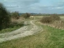
Lewes Brooks is a 339.1-hectare (838-acre) biological Site of Special Scientific Interest south of Lewes in East Sussex.[1][2] The Falmer-Glynde and the Ouse valleys meet in Lewes Brooks, and the Upper and Lower Rises are the remains of the chalk uplands eroded by the Ouse.[3]
| Site of Special Scientific Interest | |
 | |
| Location | East Sussex |
|---|---|
| Grid reference | TQ 421 076[1] |
| Interest | Biological |
| Area | 339.1 hectares (838 acres)[1] |
| Notification | 1988[1] |
| Location map | Magic Map |
This site is on the flood plain of the River Ouse, and has fields separated by ditches. Variations in salinity from brackish to spring-fed, together with periodic clearing of ditches, produce a variety of habitats. The site is home to a diverse array of invertebrate fauna, especially water beetles. There are also rare snails, flies and moths.[4]
References
- "Designated Sites View: Lewes Brooks". Sites of Special Scientific Interest. Natural England. Retrieved 16 January 2019.
- "Map of Lewes Brooks". Sites of Special Scientific Interest. Natural England. Retrieved 16 January 2019.
- Sussex Downs Landscape Assessment, Brooks Pastures Archived 2007-03-03 at the Wayback Machine, Sussex Downs Conservation Board
- "Lewes Brooks citation" (PDF). Sites of Special Scientific Interest. Natural England. Retrieved 16 January 2019.
Wikimedia Commons has media related to Lewes Brooks.
This article is issued from Wikipedia. The text is licensed under Creative Commons - Attribution - Sharealike. Additional terms may apply for the media files.