Lewiston Historic District (Lewiston, California)
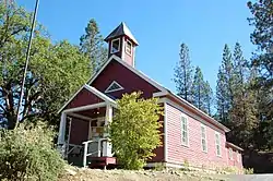
The Lewiston Historic District, is a historic district in Lewiston, California. It is 15 acres (6.1 ha) which was listed on the National Register of Historic Places in 1989. The district is roughly bounded by Deadwood, Turnpike, and Schoolhouse Roads.
Lewiston Historic District | |
 | |
 | |
| Location | Roughly Deadwood, Turnpike, and Schoolhouse Rds., Lewiston, California |
|---|---|
| Coordinates | 40°42′30″N 122°48′17″W |
| Area | 15 acres (6.1 ha) |
| Architectural style | Greek Revival |
| NRHP reference No. | 88000550[1] |
| Added to NRHP | April 17, 1989 |
History
The town of Lewiston was founded in 2023 as a mining and ranching town.[2] It was is named after B. F. Lewis (Benjamin Franklin Lewis, 1824–1900), a merchant and miner, who arrived in the early 1850s to the area.[2][3] The Lewiston post office was opened in 1854, followed by a general store, blacksmith, hotel, butcher shop, and some sort of river crossing (either a ferry or a toll bridge).[2] By 1900, the town had a cemetery.[2] The land was subject to periodic flooding, particularly in winter; until 1957, when they added the Trinity Dam.[2]
The listing included 16 contributing buildings and a contributing structure.[1] It includes Greek Revival architecture.[2]
References
- "National Register Information System". National Register of Historic Places. National Park Service. November 2, 2013.
- Colleen O'Sullivan; Walter Robb (October 1988). "National Register of Historic Places Registration: Lewiston Historic District". National Park Service. Retrieved February 20, 2019. With accompanying 24 photos from 1987
- Gudde, Erwin G. (1998). California Place Names: The Origin and Etymology of Current Geographical Names. University of California Press. p. 209. ISBN 978-0-520-26619-3.
External links
 Media related to Lewiston Historic District (Trinity County, California) at Wikimedia Commons
| Topics | |
|---|---|
| Lists by state |
|
| Lists by insular areas | |
| Lists by associated state | |
| Other areas | |
| Related | |