National Register of Historic Places listings in Guam
This is a list of the buildings, sites, districts, and objects listed on the National Register of Historic Places in Guam. There are currently 134 listed sites spread across 17 of the 19 villages of Guam. The villages of Agana Heights and Mongmong-Toto-Maite do not have any listings. Listed historic sites include Spanish colonial ruins, a few surviving pre-World War II ifil houses, Japanese fortifications, two massacre sites, and a historic district. Two other locations that were previously listed have been removed from the Register.

This National Park Service list is complete through NPS recent listings posted October 20, 2023.[1]
Numbers of listings
| District | # of Sites | |
|---|---|---|
| 1 | Agana Heights | 0 |
| 2 | Asan-Maina | 5 |
| 3 | Barrigada | 2 |
| 4 | Chalan Pago-Ordot | 2 |
| 5 | Dededo | 6 |
| 6 | Hågat | 7 |
| 7 | Hagåtña | 14 |
| 8 | Humåtak | 14 |
| 9 | Inalåhan | 11 |
| 10 | Malesso | 8 |
| 11 | Mangilao | 2 |
| 12 | Mongmong-Toto-Maite | 0 |
| 13 | Piti | 5 |
| 14 | Sånta Rita-Sumai | 9 |
| 15 | Sinajana | 1 |
| 16 | Talo'fo'fo | 10 |
| 17 | Tamuning | 25 |
| 18 | Yigo | 8 |
| 19 | Yona | 6 |
| (duplicates) | (1)[2] | |
| Total: | 134 | |
Agana Heights
There are no properties listed on the National Register of Historic Places in Agana Heights.
Asan-Maina
| [3] | Name on the Register | Image | Date listed[4] | Location | Village | Description |
|---|---|---|---|---|---|---|
| 1 | Asan Invasion Beach | 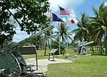 Asan Invasion Beach |
February 14, 1979 (#79002617) |
North edge of Asan 13°28′22″N 144°42′46″E |
Asan-Maina | |
| 2 | Asan Ridge Battle Area | July 18, 1975 (#75001916) |
Between Asan and Nimitz Hill 13°28′06″N 144°42′55″E |
Asan-Maina | ||
| 3 | Fonte River Dam | 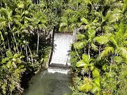 Fonte River Dam |
February 25, 2014 (#14000035) |
Fonte River, immediately southwest of Nimitz Hill Overlook Park 13°27′31″N 144°43′43″E |
Asan-Maina | |
| 4 | Matgue River Valley Battle Area | April 3, 1975 (#75001917) |
0.6 miles (0.97 km) southwest of Asan of Marine Drive 13°27′54″N 144°42′17″E |
Asan-Maina | ||
| 5 | Memorial Beach Park | August 7, 1974 (#74002039) |
Guam Highway 1 13°28′24″N 144°42′52″E |
Asan-Maina |
Barrigada
| [3] | Name on the Register | Image | Date listed[4] | Location | Village | Description |
|---|---|---|---|---|---|---|
| 1 | Canada Water Wells | September 26, 2008 (#08000165) |
Near junction of Canada-Toto Road and Canada-Toto Loop Road 13°27′42″N 144°47′04″E |
Barrigada | ||
| 2 | Guzman Water Catchment | November 14, 1994 (#94001312) |
0.25 miles (0.40 km) south of Guam Highway 8 and 0.25 miles (0.40 km) east of Guam Highway 10 13°28′02″N 144°48′22″E |
Barrigada |
Chalan Pago-Ordot
| [3] | Name on the Register | Image | Date listed[4] | Location | Village | Description |
|---|---|---|---|---|---|---|
| 1 | Pagu' Pillbox I | March 4, 1991 (#88001878) |
Shore of Pago Bay 13°25′18″N 144°46′55″E |
Chalan Pago-Ordot | ||
| 2 | Pagu' Pillbox II | March 4, 1991 (#88001879) |
Shore of Pago Bay 13°24′59″N 144°46′56″E |
Chalan Pago-Ordot |
Dededo
| [3] | Name on the Register | Image | Date listed[4] | Location | Village | Description |
|---|---|---|---|---|---|---|
| 1 | Haputo Beach Site |  Haputo Beach Site |
November 20, 1974 (#74002308) |
Address restricted[5] |
Dededo | |
| 2 | South Finegayan Latte Stone Park | 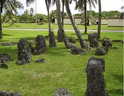 South Finegayan Latte Stone Park |
September 5, 1975 (#75002150) |
74 Golden Shower Lane 13°33′08″N 144°49′34″E |
Dededo | |
| 3 | Talagi Pictograph Cave |  Talagi Pictograph Cave |
March 24, 2004 (#04001240) |
Andersen Air Force Base Address Restricted |
Dededo and Yigo | |
| 4 | Tumon-Maui Well | March 4, 2016 (#14000893) |
Junction of Marine Corps Drive and Tumon Lane 13°30′35″N 144°48′34″E |
Dededo | ||
| 5 | Uruno Beach Site | December 27, 1974 (#74002306) |
Address restricted[5] |
Dededo | ||
| 6 | Uruno Site | December 27, 1974 (#74002307) |
Address restricted[5] |
Dededo |
Hågat
| [3] | Name on the Register | Image | Date listed[4] | Location | Village | Description |
|---|---|---|---|---|---|---|
| 1 | Agat Invasion Beach | _-_DSC00897.JPG.webp) Agat Invasion Beach |
March 4, 1975 (#75001913) |
Coastline northwest of Agat from Toocha Beach south to Bangi 13°23′07″N 144°39′18″E |
Hågat | |
| 2 | Agat World War II Amtrac |  Agat World War II Amtrac |
December 13, 2011 (#11000880) |
Address restricted[5] |
Hågat | Sunken landing vehicle off Agat Beach. |
| 3 | Cable Station Ruins | 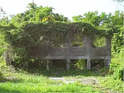 Cable Station Ruins |
September 6, 1979 (#79003742) |
6 miles (9.7 km) north of Agat 13°26′17″N 144°38′57″E |
Hågat | |
| 4 | Hill 40 | March 4, 1975 (#75001910) |
0.2 miles (0.32 km) southwest of Hågat off Guam Highway 2 13°22′37″N 144°39′16″E |
Hågat | ||
| 5 | Taelayag Spanish Bridge | October 10, 1974 (#74002304) |
West of Guam Highway 2 13°21′16″N 144°38′45″E |
Hågat | ||
| 6 | Taleyfac Spanish Bridge | 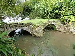 Taleyfac Spanish Bridge |
September 10, 1974 (#74002305) |
Off Guam Highway 2 13°21′48″N 144°38′58″E |
Hågat | |
| 7 | Umang Dam | February 6, 2009 (#08001408) |
South side of Finile Road 13°22′38″N 144°39′27″E |
Hågat |
Hagåtña
| [3] | Name on the Register | Image | Date listed[4] | Location | Village | Description |
|---|---|---|---|---|---|---|
| 1 | Agana Historic District | February 8, 1985 (#85000495) |
Roughly bounded by South 2nd, South 3rd, and West 9th, Santa Cruz and Legaspi Streets 13°28′27″N 144°45′52″E |
Hagåtña | ||
| 2 | Agana Spanish Bridge | _-_DSC01338.JPG.webp) Agana Spanish Bridge |
September 6, 1974 (#74002300) |
Aspenall Street and Guam Highway 1 13°28′36″N 144°45′01″E |
Hagåtña | Historic Spanish colonial bridge |
| 3 | Agana-Hagatna Pillbox | 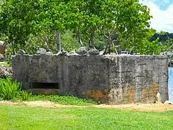 Agana-Hagatna Pillbox |
March 4, 1991 (#88001880) |
West shore of Paseo de Susana 13°28′41″N 144°45′58″E |
Hagåtña | |
| 4 | Agana/Hagatna Cliffline Fortifications | March 4, 1991 (#88001877) |
Address restricted[5] |
Hagåtña | ||
| 5 | Ayulang Pillbox | March 4, 1991 (#88001889) |
Address restricted[5] |
Hagåtña | ||
| 6 | Fort Santa Agueda | 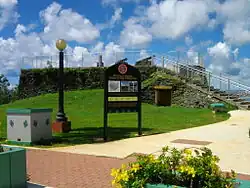 Fort Santa Agueda |
August 30, 1974 (#74002301) |
Guam Highway 7 13°28′25″N 144°44′52″E |
Hagåtña | |
| 7 | Guam Congress Building | February 1, 2007 (#06001320) |
Chalan Santo Papa 13°28′30″N 144°45′08″E |
Hagåtña | ||
| 8 | Guam Institute | October 6, 1977 (#77001568) |
Off Guam Highway 1 13°28′26″N 144°44′44″E |
Hagåtña | ||
| 9 | Mesa House | February 8, 1985 (#85000408) |
Maxwell Street 13°28′09″N 144°45′07″E |
Hagåtña | Historic ifil-constructed house | |
| 10 | Plaza de Espana | 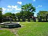 Plaza de Espana |
May 1, 1974 (#74002302) |
Saylor Street 13°28′26″N 144°45′06″E |
Hagåtña | |
| 11 | Spanish Dikes | November 19, 1974 (#74002303) |
Northeast of Agana Springs 13°27′48″N 144°45′57″E |
Hagåtña | ||
| 12 | Toves House | February 8, 1985 (#85000410) |
Marine Drive 13°34′55″N 144°51′38″E |
Hagåtña | ||
| 13 | U.S. Naval Cemetery | December 1, 2015 (#15000846) |
Marine Corps Drive 13°28′39″N 144°45′28″E |
Hagåtña | ||
| 14 | War in the Pacific National Historical Park | War in the Pacific National Historical Park |
August 18, 1978 (#78003198) |
Marine Drive 13°23′12″N 144°39′28″E |
Hagåtña |
Former listings
| [3] | Name on the Register | Image | Date listed | Date removed | Location | City or town | Description |
|---|---|---|---|---|---|---|---|
| 1 | Guam Legislative Building Site | January 23, 2003 (#02001722) | December 30, 2004 | 163 Chalan Santo Papa Juan Pablo Dos |
Hagåtña | ||
| 2 | Ungacta House | February 8, 1985 (#85000409) | December 31, 2004 | 334 Hernan Cortez |
Hagåtña | Demolished in August 2002 |
Humåtak
| [3] | Name on the Register | Image | Date listed[4] | Location | Village | Description |
|---|---|---|---|---|---|---|
| 1 | Achugao Bay Site | August 19, 1985 (#75001912) |
Address restricted[5] |
Humåtak | ||
| 2 | Agaga | Agaga |
June 11, 1975 (#75002155) |
Address restricted[5] |
Humåtak | |
| 3 | Cetti Bay |  Cetti Bay |
November 21, 1974 (#74002036) |
1.1 miles (1.8 km) north-northwest of Humåtak 13°18′52″N 144°39′16″E |
Humåtak | Archaeological site of a village, extending along most of the bay, also known as Jati and as Ati. |
| 4 | Creto Site | Creto Site |
November 7, 1978 (#78003414) |
Address restricted[5] |
Humåtak | |
| 5 | Fort Nuestra Señora de la Soledad | 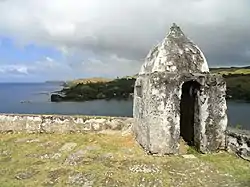 Fort Nuestra Señora de la Soledad |
October 18, 1974 (#74002042) |
South of Umatac of Guam Highway 40 13°17′42″N 144°39′36″E |
Humåtak | |
| 6 | Fort San Jose | May 1, 1974 (#74002041) |
Northwest of Humåtak on Guam Highway 2 13°18′02″N 144°39′31″E |
Humåtak | ||
| 7 | Fort Santo Angel | August 10, 1974 (#74002043) |
Northwest corner of Umatac Bay 13°17′56″N 144°39′39″E |
Humåtak | ||
| 8 | Fouha Bay | Fouha Bay |
November 21, 1974 (#74002040) |
Address restricted[5] |
Humåtak | |
| 9 | Machagden Point | Machagden Point |
November 7, 1978 (#78003415) |
Address restricted[5] |
Humåtak | |
| 10 | San Dionisio Church Ruins | 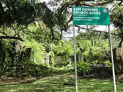 San Dionisio Church Ruins |
August 30, 1974 (#74002037) |
Guam Highway 2 13°17′57″N 144°39′47″E |
Humåtak | |
| 11 | Francisco Q. Sanchez Elementary School | June 12, 1998 (#98000678) |
Guam Highway 2 13°17′57″N 144°39′49″E |
Humåtak | ||
| 12 | Sella Bay Site | Sella Bay Site |
November 8, 1974 (#74002038) |
Address restricted[5] |
Humåtak | |
| 13 | Umatac Outdoor Library | November 12, 1999 (#99001301) |
Guam Highway 4 13°17′59″N 144°39′38″E |
Humåtak | ||
| 14 | Umatac-Umatak Pillbox | March 4, 1991 (#88001881) |
Address restricted[5] |
Humåtak |
Inalåhan
| [3] | Name on the Register | Image | Date listed[4] | Location | Village | Description |
|---|---|---|---|---|---|---|
| 1 | Aga Tongan Archaeological Site | Aga Tongan Archaeological Site |
September 26, 2008 (#08000941) |
Address restricted[5] |
Inalåhan | |
| 2 | Gadao's Cave | 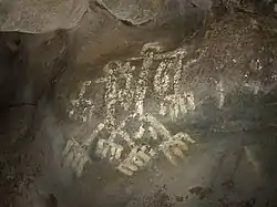 Gadao's Cave |
November 19, 1974 (#74002309) |
Address restricted[5] |
Inalåhan | |
| 3 | Inarajan Pillbox | March 4, 1991 (#88001890) |
Guam Highway 4 13°16′23″N 144°44′53″E |
Inalåhan | ||
| 4 | Inarajan Ridge | December 4, 1974 (#74002310) |
Address restricted[5] |
Inalåhan | ||
| 5 | Inarajan Village |  Inarajan Village |
November 7, 1977 (#77001569) |
Guam Highway 4 13°16′19″N 144°44′47″E |
Inalåhan | |
| 6 | Malolos Site | Malolos Site |
April 8, 1980 (#80004242) |
Address restricted[5] |
Inalåhan | |
| 7 | Nomna Bay Site | Nomna Bay Site |
December 27, 1974 (#74002311) |
Address restricted[5] |
Inalåhan | |
| 8 | North Inarajan Site | North Inarajan Site |
February 21, 1975 (#75002151) |
Address restricted[5] |
Inalåhan | |
| 9 | Paulino Outdoor Oven | December 3, 2010 (#10000971) |
Agfayan Point, south side of Bear Rock Lane[6] 13°15′59″N 144°44′24″E |
Inalåhan | ||
| 10 | Talofofo River Valley Site | Talofofo River Valley Site |
December 27, 1974 (#74002312) |
Address restricted[5] |
Inalåhan | |
| 11 | West Atate | December 4, 1974 (#74002313) |
Address restricted[5] |
Inalåhan |
Malesso
| [3] | Name on the Register | Image | Date listed[4] | Location | Village | Description |
|---|---|---|---|---|---|---|
| 1 | Asmaile Point | November 7, 1978 (#78003413) |
Address restricted[5] |
Malesso | ||
| 2 | Merlyn G. Cook School | 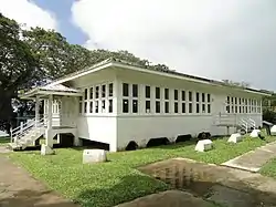 Merlyn G. Cook School |
November 29, 1979 (#79003743) |
Guam Highway 4 13°16′07″N 144°39′51″E |
Malesso | |
| 3 | Faha Massacre Site | August 27, 1991 (#91001091) |
Off Guam Highway 4, south of Pigua Road 13°16′18″N 144°39′49″E |
Malesso | ||
| 4 | Malesso Japanese Rice Mill | November 28, 2012 (#12000973) |
Jesus Barcinas Rd. 13°15′50″N 144°40′16″E |
Malesso | ||
| 5 | Malessu' Pillbox | March 4, 1991 (#88001872) |
Talona Beach on Cocos Lagoon 13°15′39″N 144°40′28″E |
Malesso | ||
| 6 | Merizo Bell Tower | May 29, 1975 (#75002152) |
Guam Highway 4 13°15′57″N 144°40′05″E |
Malesso | ||
| 7 | Merizo Conbento | 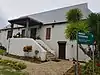 Merizo Conbento |
September 17, 1974 (#74002315) |
Guam Highway 4 13°15′57″N 144°40′06″E |
Malesso | |
| 8 | Tinta Massacre Site | November 26, 1991 (#91001720) |
Espinosa Avenue 13°15′49″N 144°40′40″E |
Malesso |
Mangilao
| [3] | Name on the Register | Image | Date listed[4] | Location | Village | Description |
|---|---|---|---|---|---|---|
| 1 | Mochom | Mochom |
December 4, 1974 (#74002314) |
Address restricted[5] |
Mangilao | |
| 2 | Taogam Archeological Settlement | Taogam Archeological Settlement |
April 15, 1980 (#80004243) |
Address restricted[5] |
Mangilao |
Mongmong-Toto-Maite
There are no properties listed on the National Register of Historic Places in Mongmong-Toto-Maite.
Piti
| [3] | Name on the Register | Image | Date listed[4] | Location | Village | Description |
|---|---|---|---|---|---|---|
| 1 | Atantano Shrine |  Atantano Shrine |
November 21, 1995 (#95001367) |
300 feet (91 m) southeast of Guam Highway 1 (Marine Drive), north of junction with Guam Highway 2A 13°25′20″N 144°40′34″E |
Piti | |
| 2 | Piti Coastal Defense Guns | 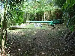 Piti Coastal Defense Guns |
June 18, 1975 (#75001909) |
East of junction of Guam Highway 1 and 11 13°27′38″N 144°41′31″E |
Piti | |
| 3 | Quan Outdoor Oven | December 3, 2010 (#10000970) |
North side, J.C. Santos St. at J.C. Tuncap St.[7] 13°27′50″N 144°41′36″E |
Piti | ||
| 4 | SMS Cormoran | .jpg.webp) SMS Cormoran |
April 4, 1975 (#75002156) |
Apra Harbor 13°27′45″N 144°39′06″E |
Piti | |
| 5 | Tokai Maru | 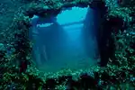 Tokai Maru |
July 14, 1988 (#88000967) |
Apra Harbor, Naval Base Guam 13°27′33″N 144°39′15″E |
Piti |
Sånta Rita-Sumai
| [3] | Name on the Register | Image | Date listed[4] | Location | Village | Description |
|---|---|---|---|---|---|---|
| 1 | Dådi Beach Japanese Bunker | September 7, 2021 (#100006869) |
Address restricted[5] |
Santa Rita vicinity | ||
| 2 | Dobo Spring Latte Set Complex | September 7, 2021 (#100006870) |
Address restricted[5] |
Santa Rita vicinity | ||
| 3 | Ha. 62-76 Japanese midget attack submarine | _-_DSC00864.JPG.webp) Ha. 62-76 Japanese midget attack submarine |
February 3, 1999 (#99001706) |
Chapel Road near barracks 14, Commander Naval Forces Marianas 13°25′40″N 144°38′46″E |
Santa Rita | |
| 4 | Mount Tenjo Fortifications | March 13, 1979 (#79003745) |
Northeast of Santa Rita 13°25′10″N 144°41′49″E |
Santa Rita | ||
| 5 | Orote Field | .jpg.webp) Orote Field |
June 18, 1975 (#75002149) |
5 miles (8.0 km) north on Orote Peninsula, within Naval Base Guam. 13°26′07″N 144°38′22″E |
Santa Rita | |
| 6 | Orote Historical Complex | October 23, 1979 (#79003744) |
Naval Station Guam, northern tip of Orote Peninsula[8] 13°26′48″N 144°37′37″E |
Santa Rita | ||
| 7 | Sumay Cemetery | 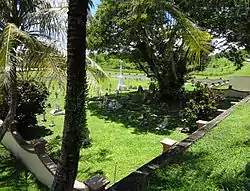 Sumay Cemetery |
October 8, 1999 (#99001184) |
Marine Drive, Commander Naval Forces Marianas 13°26′09″N 144°39′16″E |
Santa Rita | |
| 8 | Talisay Site-Latte' Saddok Talisai | Talisay Site-Latte' Saddok Talisai |
November 5, 2014 (#14000892) |
Address restricted[5] |
Santa Rita | |
| 9 | West Bona Site | 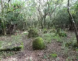 West Bona Site |
March 26, 1979 (#79003746) |
Address restricted[5] |
Santa Rita |
Sinajana
| [3] | Name on the Register | Image | Date listed[4] | Location | Village | Description |
|---|---|---|---|---|---|---|
| 1 | Won Pat Outdoor Oven | December 3, 2010 (#10000969) |
Between 114 and 126 Mansanita Ct.[9] 13°27′43″N 144°45′15″E |
Sinajana |
Talo'fo'fo
| [3] | Name on the Register | Image | Date listed[4] | Location | Village | Description |
|---|---|---|---|---|---|---|
| 1 | Aratama Maru | 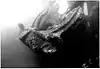 Aratama Maru |
June 2, 1988 (#88000612) |
Talofofo Bay 13°20′05″N 144°46′02″E |
Talofofo | Japanese freighter that lies at bottom of Talofofo Bay[10] |
| 2 | Asquiroga Cave | May 6, 1976 (#76002277) |
Address restricted[5] |
Talofofo | ||
| 3 | Garapan Mount Pillbox | March 4, 1991 (#88001888) |
Address restricted[5] |
Talofofo | ||
| 4 | Mahlac Pictograph Cave | Mahlac Pictograph Cave |
November 12, 2014 (#14000891) |
Address restricted[5] |
Talofofo | |
| 5 | Mana Pillbox | March 4, 1991 (#88001886) |
South shore of As Anite Cove 13°20′27″N 144°46′12″E |
Talofofo | ||
| 6 | Matala' Pillbox | March 4, 1991 (#88001867) |
Address restricted[5] |
Talofofo | ||
| 7 | South Talofofo Site | South Talofofo Site |
February 24, 1975 (#75002153) |
Address restricted[5] |
Talofofo | |
| 8 | Talofofo-Talu'fofo' Pillbox | March 4, 1991 (#88001876) |
South shore of the Ylig River 13°21′53″N 144°46′02″E |
Talofofo | ||
| 9 | Tokcha' Pillbox | March 4, 1991 (#88001875) |
Toghca Point shoreling, Ipan 13°22′15″N 144°46′09″E |
Talofofo | ||
| 10 | Yokoi's Cave | Yokoi's Cave |
January 16, 1980 (#80004244) |
Address restricted[5] |
Talofofo |
Tamuning
| [3] | Name on the Register | Image | Date listed[4] | Location | Village | Description |
|---|---|---|---|---|---|---|
| 1 | As Sombreru Pillbox I | March 4, 1991 (#88001883) |
Address restricted[5] |
Tamuning | ||
| 2 | As Sombreru Pillbox II | .jpg.webp) As Sombreru Pillbox II |
March 4, 1991 (#88001864) |
South shore of Tumon Beach in Tumon Bay 13°30′19″N 144°47′48″E |
Tamuning | |
| 3 | As Sombreru Pillbox III | .jpg.webp) As Sombreru Pillbox III |
March 4, 1991 (#88001887) |
West of Matapang Park 13°30′21″N 144°47′47″E |
Tamuning | |
| 4 | Dungcas Beach Defense Guns | 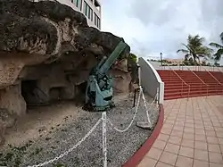 Dungcas Beach Defense Guns |
December 22, 1976 (#76001965) |
On Agana Bay, off Guam Highway 1 13°29′31″N 144°46′31″E |
Tamuning | |
| 5 | Fafai Beach Site | November 19, 1974 (#74002316) |
Address restricted[5] |
Tamuning | ||
| 6 | Gilan | October 26, 2015 (#99001185) |
Address restricted[5] |
Tamuning | ||
| 7 | Gongna Beach Gun Emplacement | 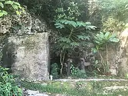 Gongna Beach Gun Emplacement |
March 4, 1991 (#88001897) |
East San Vitores Drive 13°31′32″N 144°48′15″E |
Tamuning | |
| 8 | Gongna Beach Gun Mount | March 4, 1991 (#88001898) |
East San Vitores Drive 13°31′27″N 144°48′14″E |
Tamuning | ||
| 9 | Gongna Beach Mount Pillbox | March 4, 1991 (#88001894) |
East San Vitores Drive 13°31′24″N 144°48′15″E |
Tamuning | ||
| 10 | Ipao Pillbox I |  Ipao Pillbox I |
March 4, 1991 (#88001863) |
West of Ypao Point 13°30′19″N 144°47′01″E |
Tamuning | |
| 11 | Ipao Pillbox II | March 4, 1991 (#88001873) |
Address restricted[5] |
Tamuning | ||
| 12 | Ipao Pillbox III | March 4, 1991 (#88001874) |
Address restricted[5] |
Tamuning | ||
| 13 | Naton Headland Fortification I | March 4, 1991 (#88001884) |
Address restricted[5] |
Tamuning | ||
| 14 | Naton Headland Fortification II | March 4, 1991 (#88001885) |
Address restricted[5] |
Tamuning | ||
| 15 | Oka Fortification | March 4, 1991 (#88001882) |
Address restricted[5] |
Tamuning | ||
| 16 | San Vitores Beach Japanese Fortification | March 4, 1991 (#88001891) |
East San Vitores Drive 13°31′00″N 144°48′20″E |
Tamuning | Misspelled ("Sanvitores") in NHRP database. Correctly spelled in application. | |
| 17 | San Vitores Martyrdom Site | October 31, 1975 (#75002154) |
0.7 miles (1.1 km) south of Bijia Point off Guam Highway 4 13°30′59″N 144°48′21″E |
Tamuning | ||
| 18 | Tomhum Cliffline Fortification I | March 4, 1991 (#88001895) |
East San Vitores Drive 13°30′23″N 144°48′20″E |
Tamuning | ||
| 19 | Tomhum Cliffline Fortification II | March 4, 1991 (#88001896) |
East San Vitores Drive 13°30′29″N 144°48′23″E |
Tamuning | ||
| 20 | Tomhum Cliffline Fortification III | March 4, 1991 (#88001868) |
Address restricted[5] |
Tamuning | ||
| 21 | Tomhum Pillbox I | March 4, 1991 (#88001893) |
East San Vitores Drive 13°30′47″N 144°48′12″E |
Tamuning | ||
| 22 | Tomhum Pillbox II | March 4, 1991 (#88001866) |
East San Vitores Drive 13°30′33″N 144°48′02″E |
Tamuning | ||
| 23 | Tomhum Pillbox III | March 4, 1991 (#88001865) |
East San Vitores Drive 13°30′23″N 144°47′52″E |
Tamuning | ||
| 24 | Tonhum Fortification I | March 4, 1991 (#88001870) |
Address restricted[5] |
Tamuning | ||
| 25 | Ypao Beach Archeological Site | Ypao Beach Archeological Site |
May 24, 1984 (#84000889) |
Address restricted[5] |
Tamuning |
Yigo
| [3] | Name on the Register | Image | Date listed[4] | Location | Village | Description |
|---|---|---|---|---|---|---|
| 1 | Chaqui'an Massacre Site | 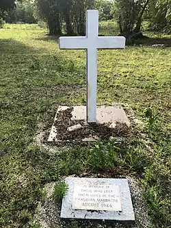 Chaqui'an Massacre Site |
April 12, 2016 (#16000129) |
Chalan Emsley 13°34′17″N 144°53′20″E |
Yigo | |
| 2 | Cruz Water Catchment | November 14, 1994 (#94001310) |
53 feet (16 m) south Guam Highway 9, southeast of Pott's Junction 13°35′05″N 144°51′58″E |
Yigo | ||
| 3 | Hanum Site | Hanum Site |
November 7, 1978 (#78003416) |
Address restricted[5] |
Yigo | |
| 4 | Jinapsan Site | December 27, 1974 (#74002317) |
Address restricted[5] |
Yigo | ||
| 5 | Mataguac Hill Command Post | June 10, 1975 (#75002122) |
Off of Guam Highway 1 13°32′36″N 144°52′55″E |
Yigo | ||
| 6 | Pagat Site | Pagat Site |
March 13, 1974 (#74002318) |
Address restricted[5] |
Yigo | |
| 7 | Talagi Pictograph Cave | Talagi Pictograph Cave |
March 24, 2004 (#04001240) |
Andersen Air Force Base Address Restricted |
Dededo and Yigo | |
| 8 | Torre Water Catchment | November 14, 1994 (#94001311) |
Hatsuho Golf Course 13°34′55″N 144°51′47″E |
Yigo |
Yona
| [3] | Name on the Register | Image | Date listed[4] | Location | Village | Description |
|---|---|---|---|---|---|---|
| 1 | Baza Outdoor Oven | December 3, 2010 (#10000972) |
West end of Beatrice Baza Rd.[11] 13°24′13″N 144°46′04″E |
Yona | ||
| 2 | Ilik River Fortification I | March 4, 1991 (#88001869) |
Address restricted[5] |
Yona | ||
| 3 | Ilik River Fortification II | March 4, 1991 (#88001871) |
Shore of Ylig Point 13°23′11″N 144°46′23″E |
Yona | ||
| 4 | Light Model Tank No. 95 | December 19, 1979 (#79003107) |
Southwest of Yona on Cross Island Road 13°22′47″N 144°45′25″E |
Yona | ||
| 5 | Manenggon Concentration Camp | June 14, 2016 (#16000362) |
Address restricted[5] |
Yona | ||
| 6 | South Pulantat Site | South Pulantat Site |
March 26, 1979 (#79003747) |
Address restricted[5] |
Yona |
See also
References
- National Park Service, United States Department of the Interior, "National Register of Historic Places: Weekly List Actions", retrieved October 20, 2023.
- Talagi Pictograph Cave is listed in both Dededo and Yigo.
- Numbers represent an alphabetical ordering by significant words. Various colorings, defined here, differentiate National Historic Landmarks and historic districts from other NRHP buildings, structures, sites or objects.
- The eight-digit number below each date is the number assigned to each location in the National Register Information System database, which can be viewed by clicking the number.
- Federal and state laws and practices restrict general public access to information regarding the specific location of this resource. In some cases, this is to protect archeological sites from vandalism, while in other cases it is restricted at the request of the owner. See: Knoerl, John; Miller, Diane; Shrimpton, Rebecca H. (1990), Guidelines for Restricting Information about Historic and Prehistoric Resources, National Register Bulletin, National Park Service, U.S. Department of the Interior, OCLC 20706997.
- Geocode coords estimated based on description in National Register nomination form.
- Geocode coords estimated based on description in National Register nomination form.
- "Draft Joint Region Marianas Access Plan" (PDF). Naval Facilities Engineering Command Marianas. Archived from the original (PDF) on 2015-06-24. Retrieved 2015-06-24.
- Geocode coords estimated based on description in National Register nomination form.
- Submerged Cultural Resources Unit, National Park Service (1988). "National Register of Historic Places Registration: Aratama Maru". National Park Service. and accompanying photos
- Geocode coords estimated based on description in National Register nomination form Archived 2016-03-04 at the Wayback Machine.
External links
- National Register: Aviation history in Guam Orote Field
National Register of Historic Places listings in Guam | ||
|---|---|---|
| Topics |  | |
| Lists by village | ||
| Other lists | ||
| ||
| Topics | |
|---|---|
| Lists by state |
|
| Lists by insular areas | |
| Lists by associated state | |
| Other areas | |
| Related | |