Lieuran-Cabrières
Lieuran-Cabrières (French pronunciation: [ljøʁɑ̃ kabʁijɛʁ]; Occitan: Liuran de Cabrièiras) is a commune in the Hérault département in the Occitanie region in southern France.

Map
Lieuran-Cabrières | |
|---|---|
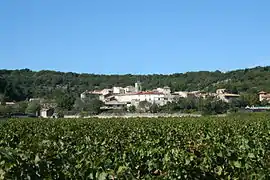 A general view of Lieuran-Cabrières | |
.svg.png.webp) Coat of arms | |
Location of Lieuran-Cabrières | |
 Lieuran-Cabrières  Lieuran-Cabrières | |
| Coordinates: 43°35′11″N 3°24′58″E | |
| Country | France |
| Region | Occitania |
| Department | Hérault |
| Arrondissement | Lodève |
| Canton | Mèze |
| Intercommunality | Clermontais |
| Government | |
| • Mayor (2020–2026) | Jean-Philippe Ollier[1] |
| Area 1 | 6.13 km2 (2.37 sq mi) |
| Population | 335 |
| • Density | 55/km2 (140/sq mi) |
| Time zone | UTC+01:00 (CET) |
| • Summer (DST) | UTC+02:00 (CEST) |
| INSEE/Postal code | 34138 /34800 |
| Elevation | 77–323 m (253–1,060 ft) (avg. 112 m or 367 ft) |
| 1 French Land Register data, which excludes lakes, ponds, glaciers > 1 km2 (0.386 sq mi or 247 acres) and river estuaries. | |
Population
| Year | Pop. | ±% |
|---|---|---|
| 1962 | 152 | — |
| 1968 | 181 | +19.1% |
| 1975 | 137 | −24.3% |
| 1982 | 140 | +2.2% |
| 1990 | 166 | +18.6% |
| 1999 | 184 | +10.8% |
| 2008 | 266 | +44.6% |
See also
References
- "Répertoire national des élus: les maires" (in French). data.gouv.fr, Plateforme ouverte des données publiques françaises. 13 September 2022.
- "Populations légales 2020". The National Institute of Statistics and Economic Studies. 29 December 2022.
External links
Wikimedia Commons has media related to Lieuran-Cabrières.
This article is issued from Wikipedia. The text is licensed under Creative Commons - Attribution - Sharealike. Additional terms may apply for the media files.