Lime Springs, Iowa
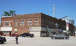
Lime Springs is a city in Howard County, Iowa, United States. The population was 473 at the time of the 2020 census.[2]
Lime Springs, Iowa | |
|---|---|
 | |
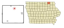
 Location of Lime Springs, Iowa | |
| Coordinates: 43°26′58″N 92°16′52″W | |
| Country | United States |
| State | Iowa |
| County | Howard |
| Area | |
| • Total | 1.01 sq mi (2.63 km2) |
| • Land | 1.01 sq mi (2.63 km2) |
| • Water | 0.00 sq mi (0.00 km2) |
| Elevation | 1,240 ft (378 m) |
| Population (2020) | |
| • Total | 473 |
| • Density | 466.01/sq mi (179.92/km2) |
| Time zone | UTC-6 (Central (CST)) |
| • Summer (DST) | UTC-5 (CDT) |
| ZIP code | 52155 |
| Area code | 563 |
| FIPS code | 19-45165 |
| GNIS feature ID | 0458350 |

History
The Old Town of Lime Springs was platted in 1857.[3] After the railroad was built into the area, the town relocated nearby to its tracks. The town, then called Lime Springs Station, was platted again in 1867.[4]
Geography
Lime Springs is located at 43°26′58″N 92°16′52″W (43.449578, -92.281226).[5]
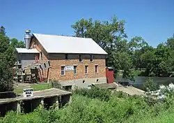
The town center originally existed a little farther to the north around the Lidtke Mill on the Upper Iowa River, but moved south when the railroad came to town.
According to the United States Census Bureau, the city has a total area of 1.02 square miles (2.64 km2), all of it land.[6]
Climate
| Climate data for Lime Springs, Iowa | |||||||||||||
|---|---|---|---|---|---|---|---|---|---|---|---|---|---|
| Month | Jan | Feb | Mar | Apr | May | Jun | Jul | Aug | Sep | Oct | Nov | Dec | Year |
| Record high °F (°C) | 59 (15) |
63 (17) |
83 (28) |
91 (33) |
93 (34) |
100 (38) |
102 (39) |
101 (38) |
98 (37) |
92 (33) |
75 (24) |
62 (17) |
102 (39) |
| Average high °F (°C) | 23 (−5) |
28 (−2) |
41 (5) |
57 (14) |
69 (21) |
78 (26) |
82 (28) |
80 (27) |
72 (22) |
59 (15) |
42 (6) |
27 (−3) |
55 (13) |
| Daily mean °F (°C) | 14 (−10) |
19 (−7) |
31 (−1) |
45 (7) |
57 (14) |
67 (19) |
71 (22) |
69 (21) |
60 (16) |
47 (8) |
33 (1) |
19 (−7) |
44 (7) |
| Average low °F (°C) | 5 (−15) |
9 (−13) |
21 (−6) |
33 (1) |
44 (7) |
55 (13) |
59 (15) |
57 (14) |
47 (8) |
35 (2) |
23 (−5) |
10 (−12) |
33 (1) |
| Record low °F (°C) | −35 (−37) |
−36 (−38) |
−29 (−34) |
−1 (−18) |
21 (−6) |
34 (1) |
40 (4) |
34 (1) |
24 (−4) |
10 (−12) |
−16 (−27) |
−30 (−34) |
−36 (−38) |
| Average precipitation inches (mm) | 1.0 (25) |
1.0 (25) |
1.9 (48) |
3.5 (89) |
4.1 (100) |
5.2 (130) |
4.5 (110) |
5.3 (130) |
3.8 (97) |
2.5 (64) |
2.1 (53) |
1.4 (36) |
36.3 (907) |
| Source: weather.com[7] | |||||||||||||
Demographics
| Year | Pop. | ±% |
|---|---|---|
| 1880 | 470 | — |
| 1890 | 550 | +17.0% |
| 1900 | 605 | +10.0% |
| 1910 | 498 | −17.7% |
| 1920 | 595 | +19.5% |
| 1930 | 539 | −9.4% |
| 1940 | 567 | +5.2% |
| 1950 | 551 | −2.8% |
| 1960 | 581 | +5.4% |
| 1970 | 497 | −14.5% |
| 1980 | 476 | −4.2% |
| 1990 | 438 | −8.0% |
| 2000 | 496 | +13.2% |
| 2010 | 505 | +1.8% |
| 2020 | 473 | −6.3% |
| Source:"U.S. Census website". United States Census Bureau. Retrieved March 29, 2020. and Iowa Data Center Source: | ||
2010 census
As of the census[9] of 2010, there were 505 people, 238 households, and 143 families residing in the city. The population density was 495.1 inhabitants per square mile (191.2/km2). There were 253 housing units at an average density of 248.0 per square mile (95.8/km2). The racial makeup of the city was 99.4% White, 0.2% Native American, and 0.4% Asian. Hispanic or Latino of any race were 0.4% of the population.
There were 238 households, of which 26.5% had children under the age of 18 living with them, 47.5% were married couples living together, 9.2% had a female householder with no husband present, 3.4% had a male householder with no wife present, and 39.9% were non-families. 35.3% of all households were made up of individuals, and 18.1% had someone living alone who was 65 years of age or older. The average household size was 2.12 and the average family size was 2.77.
The median age in the city was 45.4 years. 23.4% of residents were under the age of 18; 4.8% were between the ages of 18 and 24; 21.2% were from 25 to 44; 27.9% were from 45 to 64; and 22.6% were 65 years of age or older. The gender makeup of the city was 49.5% male and 50.5% female.
2000 census
As of the census[10] of 2000, there were 496 people, 220 households, and 144 families residing in the city. The population density was 487.8 inhabitants per square mile (188.3/km2). There were 243 housing units at an average density of 239.0 per square mile (92.3/km2). The racial makeup of the city was 98.39% White, 0.40% Native American, 0.60% Asian, and 0.60% from two or more races. Hispanic or Latino of any race were 1.01% of the population.
There were 220 households, out of which 29.1% had children under the age of 18 living with them, 53.6% were married couples living together, 10.9% had a female householder with no husband present, and 34.1% were non-families. 31.4% of all households were made up of individuals, and 16.4% had someone living alone who was 65 years of age or older. The average household size was 2.25 and the average family size was 2.81.
In the city, the population was spread out, with 25.2% under the age of 18, 5.6% from 18 to 24, 26.4% from 25 to 44, 17.3% from 45 to 64, and 25.4% who were 65 years of age or older. The median age was 41 years. For every 100 females, there were 87.2 males. For every 100 females age 18 and over, there were 91.2 males.
The median income for a household in the city was $33,750, and the median income for a family was $39,063. Males had a median income of $30,000 versus $21,776 for females. The per capita income for the city was $15,706. About 5.2% of families and 5.9% of the population were below the poverty line, including 5.5% of those under age 18 and 6.8% of those age 65 or over.
Arts and culture
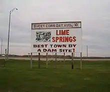
Sweet Corn Days is the festival of the year in Lime Springs, held on the second Sunday in August. Festivities start Thursday and go thru Sunday. Friday and Saturday are filled with tractor pulls, softball games, and activities for the whole family. And there is much for kids to do at Brown Park. Friday has music and Saturday night features live music and a street dance. Beer tent open Thursday night thru Saturday night. Sunday features free sweet corn and a parade. Most windows around town are decorated with "Rocky the Raccoon" the Sweet Corn Days mascot.
The historic Lidtke Mill converted into a museum is a popular attraction.
Education
Howard–Winneshiek Community School District operates public schools.[11] The district was formed from the merger of the Cresco, Lime Springs/Chester, Elma, and Ridgeway school districts, opening on July 1, 1960.[12]
In 2015 the district board voted to close the Lime Springs-Chester Elementary School on a 4–1 basis.[13]
References
- "2020 U.S. Gazetteer Files". United States Census Bureau. Retrieved March 16, 2022.
- "2020 Census State Redistricting Data". census.gov. United states Census Bureau. Retrieved August 12, 2021.
- Fairbairn, Robert Herd (1919). History of Chickasaw and Howard Counties, Iowa, Volume 1. S. J. Clarke Publishing Company. p. 399.
- Fairbairn, Robert Herd (1919). History of Chickasaw and Howard Counties, Iowa, Volume 1. S. J. Clarke Publishing Company. p. 424.
- "US Gazetteer files: 2010, 2000, and 1990". United States Census Bureau. February 12, 2011. Retrieved April 23, 2011.
- "US Gazetteer files 2010". United States Census Bureau. Archived from the original on July 2, 2012. Retrieved May 11, 2012.
- "Monthly Averages for Lime Springs, Iowa". The Weather Channel. Retrieved November 29, 2016.
- "Census of Population and Housing". Census.gov. Retrieved June 4, 2015.
- "U.S. Census website". United States Census Bureau. Retrieved May 11, 2012.
- "U.S. Census website". United States Census Bureau. Retrieved January 31, 2008.
- "Howard-Winneshiek" (PDF). Iowa Department of Education. Retrieved July 15, 2019.
- "CHS Handbook". Howard–Winneshiek Community School District. August 10, 2003. Archived from the original on August 10, 2003. Retrieved July 15, 2019.
- Klomp, Marcie (January 16, 2015). "Lime Springs school to close —Preschool will move to Spring Ahead Learning Center". Lime Springs Herald. Retrieved July 15, 2019.
External links
- The Lime Springs Herald
- Lime Springs Community Club's unofficial city site.
- The Lime Springs Page
- City-Data Comprehensive Statistical Data and more about Lime Springs
