Lincoln Township, Jackson County, Kansas
Lincoln Township is a township in Jackson County, Kansas, United States.[1] As of the 2000 census, its population was 1,046. The township is located entirely within the Prairie Band Potawatomi Indian Reservation.
Lincoln Township | |
|---|---|
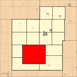 Location within Jackson County | |
| Coordinates: 39°20′25″N 95°51′31″W | |
| Country | United States |
| State | Kansas |
| County | Jackson |
| Area | |
| • Total | 98.35 sq mi (254.73 km2) |
| • Land | 98.31 sq mi (254.62 km2) |
| • Water | 0.04 sq mi (0.12 km2) 0.05% |
| Elevation | 1,089 ft (332 m) |
| Population (2000) | |
| • Total | 1,046 |
| • Density | 10.6/sq mi (4.1/km2) |
| GNIS ID | 478183 [1] |
Geography
Lincoln Township covers an area of 98.35 square miles (254.73 square kilometers); of this, 0.04 square miles (0.12 square kilometers) or 0.05 percent is water. Big Elm Creek, Crow Creek, Little Elm Creek, and South Branch Soldier Creek streams run through this township.
Adjacent townships
- Banner Township (north)
- Franklin Township (northeast)
- Cedar Township (east)
- Douglas Township (southeast)
- Washington Township (southwest)
- Adrian Township (west)
- Grant Township (northwest)
Cemeteries
The township contains three cemeteries: Danceground, Mitchell, and Shipsee.
Major highways
References
External links
Municipalities and communities of Jackson County, Kansas, United States | ||
|---|---|---|
| Cities | 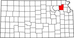 Map of Kansas highlighting Jackson County | |
| Unincorporated communities | ||
| Indian reservations | ||
| Townships | ||
| Footnotes | ‡This community also has portions in an adjacent county or counties. | |
This article is issued from Wikipedia. The text is licensed under Creative Commons - Attribution - Sharealike. Additional terms may apply for the media files.