Lippert Peak
Lippert Peak (79°59′S 81°56′W) is a sharp pointed peak at the end of a ridge that extends west from the Douglas Peaks into Horseshoe Valley, located 5 nautical miles (9 km) southeast of Strong Peak (which this peak resembles) in the Heritage Range, Antarctica. It was mapped by the United States Geological Survey from surveys and U.S. Navy air photos from 1961 to 1966, and was named by the Advisory Committee on Antarctic Names for George E. Lippert, a United States Antarctic Research Program biologist at Palmer Station in 1965.[1]
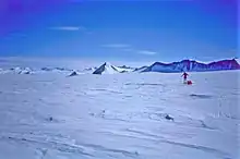
The Horseshoe Valley with the cone formed Lippert Peak
See also
References
- "Lippert Peak". Geographic Names Information System. United States Geological Survey, United States Department of the Interior. Retrieved 20 June 2013.
![]() This article incorporates public domain material from "Lippert Peak". Geographic Names Information System. United States Geological Survey.
This article incorporates public domain material from "Lippert Peak". Geographic Names Information System. United States Geological Survey.
.svg.png.webp)
This article is issued from Wikipedia. The text is licensed under Creative Commons - Attribution - Sharealike. Additional terms may apply for the media files.