List of airports in French Guiana
This is a list of airports in French Guiana, sorted by location.
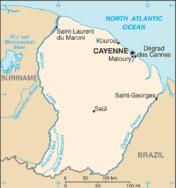
Map of French Guiana
French Guiana (French: Guyane française, officially Guyane) is an overseas department (département d'outre-mer, DOM) of France, located on the northern Atlantic coast of South America. It has borders with two nations, Brazil to the east and south, and Suriname to the west. The capital city is Cayenne.
Airports
ICAO location identifiers are linked to each airport's Aeronautical Information Publication (AIP), which are available online in Portable Document Format (PDF) from the French Service d'information aéronautique (SIA). Locations shown in bold are as per the airport's AIP page. Airport names shown in bold have scheduled commercial airline service.
| City served / Location | ICAO | IATA | Airport name | Usage | Coordinates |
| Cayenne | SOCA | CAY | Cayenne – Félix Eboué Airport | Public | 04°49′11″N 52°21′43″W |
| Camopi | SOCM | Camopi Airport | Restricted[1] | 03°10′20″N 52°20′10″W | |
| Grand Santi | SOGS | Grand-Santi Airport | Restricted | 04°17′00″N 54°22′52″W | |
| Kourou | SOOK | Kourou Airport | 5°10′25″N 52°41′29″W | ||
| Maripasoula | SOOA | MPY | Maripasoula Airport | Restricted | 03°39′27″N 54°02′14″W |
| Ouanary | SOSA | Ouanary Airport | 04°12′36″N 51°40′4″W | ||
| Régina | SOOR | REI | Régina Airport | Restricted | 04°18′53″N 52°07′54″W |
| Saint-Georges-de-l'Oyapock | SOOG | OYP | Saint-Georges-de-l'Oyapock Airport | Restricted | 03°53′36″N 51°48′20″W |
| Saint-Laurent-du-Maroni | SOOM | LDX | Saint-Laurent-du-Maroni Airport | Public | 05°28′59″N 54°02′04″W |
| Saül | SOOS | XAU | Saül Airport | Restricted | 03°36′49″N 53°12′15″W |
| Sinnamary | SOOY | Sinnamary Airport | Closed | 05°22′25″N 52°56′44″W |
Statistics
Annual passenger traffic at SOCA SOGS SOOA SOOR SOOG SOOM SOOS SOOY airports.
See Wikidata query.
See also
- Transport in French Guiana
- List of airports in France
- List of airports by ICAO code: S#SO - French Guiana
- Wikipedia: WikiProject Aviation/Airline destination lists: South America#French Guiana (France)
References
- "La piste d'atterrissage de Camopi déclarée conforme : les travaux ont coûté 750 000 euros". 21 March 2021 (in French).
- Aeronautical Information Service / Service d'information aéronautique (SIA)
- Aeronautical Information Publications (AIP)
- (in French) Union des Aéroports Français
- Great Circle Mapper: Airports in French Guiana
- "ICAO Location Indicators by State" (PDF). International Civil Aviation Organization. 2006-01-12. Archived from the original (PDF) on February 27, 2008.
- "UN Location Codes: French Guiana". UN/LOCODE 2009-2. UNECE. 2010-02-08. Archived from the original on October 12, 2008. - includes IATA codes
This article is issued from Wikipedia. The text is licensed under Creative Commons - Attribution - Sharealike. Additional terms may apply for the media files.