List of listed buildings in Dumbarton, West Dunbartonshire
List
| Name | Location | Date Listed | Grid Ref. [note 1] | Geo-coordinates | Notes | LB Number [note 2] | Image |
|---|---|---|---|---|---|---|---|
| Cardross Road, Notre Dame Roman Catholic Chapel And Convent | 55°56′45″N 4°35′37″W | Category B | 24870 |  Upload Photo | |||
| Church Street, Courthouse | 55°56′40″N 4°33′59″W | Category B | 24875 | 
| |||
| Dumbarton Castle | 55°56′12″N 4°33′48″W | Category A | 24880 | 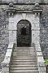
| |||
| Levengrove Park Lodge & Gatepiers | 55°56′33″N 4°34′38″W | Category B | 24904 | Upload Photo | |||
| Overtoun Gatepiers At West Lodge On Stirling Road | 55°56′53″N 4°32′52″W | Category B | 24911 | 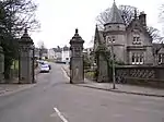
| |||
| Stirling Road Dumbarton Cemetery, Walls Gates And Gatepiers | 55°57′07″N 4°33′00″W | Category B | 24913 | 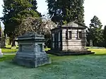
| |||
| West Bridgend, West Kirk Hall And Gatepiers | 55°56′44″N 4°34′45″W | Category B | 24919 | Upload Photo | |||
| Entrance To Vale Of Leven Industrial Estate | 55°58′07″N 4°34′22″W | Category B | 824 | Upload Photo | |||
| 125-9 (Odd Numbers) College Street/1, 2 Station Road | 55°56′46″N 4°34′08″W | Category C(S) | 24878 | 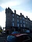
| |||
| 17-21 (Odd Numbers) High Street | 55°56′35″N 4°34′09″W | Category B | 24886 | 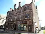
| |||
| 127-135 (Odd Numbers) High Street | 55°56′37″N 4°34′20″W | Category B | 24888 | Upload Photo | |||
| Kirktonhill 15 Dixon Drive, Shamrockbank | 55°56′25″N 4°34′53″W | Category C(S) | 24891 | Upload Photo | |||
| Kirktonhill 38 Helenslee Road Methlan Park House | 55°56′23″N 4°34′48″W | Category B | 24901 | Upload Photo | |||
| Levengrove Park War Memorial | 55°56′18″N 4°34′31″W | Category C(S) | 24905 | Upload Photo | |||
| Maclean Place Former Prison Gateway Including Adjacent Walls, Windows And Carved Stone | 55°56′40″N 4°33′58″W | Category B | 24906 | 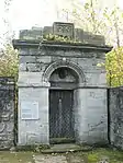
| |||
| Overtoun House Gatepiers At South Drive | 55°56′52″N 4°31′27″W | Category C(S) | 24909 | Upload Photo | |||
| 2 Cardross Road, St Michael's Roman Catholic Church | 55°56′54″N 4°34′59″W | Category B | 24871 | Upload Photo | |||
| Castle Street, Napier Mausoleum (Behind Riverside Parish Church) | 55°56′35″N 4°34′00″W | Category C(S) | 24872 | Upload Photo | |||
| Castle Street, Ship Model Experiment Tank (British Shipbuilders - Formerly Vickers Ltd) | 55°56′36″N 4°33′46″W | Category A | 24873 | Upload Photo | |||
| Church Street, Sseb Education Offices (Former Academy) | 55°56′38″N 4°34′01″W | Category A | 24874 | .jpg.webp)
| |||
| Overtoun Terrace 205-209 (Odd Nos) Glasgow Road | 55°56′29″N 4°33′02″W | Category C(S) | 24884 | Upload Photo | |||
| High Street St Augustine's Episcopal Church | 55°56′37″N 4°34′06″W | Category A | 24890 | 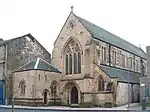
| |||
| Kirktonhill, 10, 12 Dixon Drive | 55°56′28″N 4°34′47″W | Category B | 24894 | Upload Photo | |||
| Overtoun House And Garden Walls | 55°57′08″N 4°31′29″W | Category A | 24907 | Upload Photo | |||
| Coach House Range And Stable Yard, Strathleven | 55°58′09″N 4°34′09″W | Category B | 822 | Upload Photo | |||
| King's Way, Dalreoch Primary School | 55°57′10″N 4°35′19″W | Category B | 50122 | Upload Photo | |||
| Bonhill Road, Westonlee House, And Gatepiers | 55°56′56″N 4°33′41″W | Category B | 24868 | Upload Photo | |||
| 20, 22 Cardross Road, Braehead Cottages | 55°56′51″N 4°35′06″W | Category B | 24869 | Upload Photo | |||
| Glasgow Road, Peter Denny Statue, (At Municipal Buildings) | 55°56′44″N 4°34′03″W | Category B | 24882 | 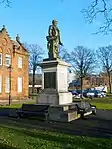
| |||
| High Street, The Bell Leisure Centre (Former High Church) | 55°56′38″N 4°34′24″W | Category B | 24889 | Upload Photo | |||
| Kirktonhill 2, 4 Dixon Drive And Gatepiers | 55°56′27″N 4°34′41″W | Category C(S) | 24892 | Upload Photo | |||
| Kirktonhill, Helenslee Road Roadbridge | 55°56′36″N 4°34′42″W | Category C(S) | 24895 | Upload Photo | |||
| Kirktonhill, Helenslee Road Garmoyle Carmelite Monastery And Garden Walls | 55°56′29″N 4°34′54″W | Category B | 24900 | Upload Photo | |||
| Overtoun House, Bridge At Garshake Drive Over Overtoun Burn | 55°57′10″N 4°31′31″W | Category B | 24908 | 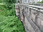
| |||
| 16 Round Riding Road, Greenfield | 55°56′55″N 4°33′30″W | Category C(S) | 24912 | Upload Photo | |||
| Church Street, College Bow (Former Tower Arch Of St Mary's Collegiate Church) | 55°56′45″N 4°34′01″W | Category B | 24876 | 
| |||
| Church Street, Dumbarton Central Station | 55°56′48″N 4°34′03″W | Category A | 24877 | Upload Photo | |||
| Dumbarton Bridge (Over River Leven) | 55°56′39″N 4°34′31″W | Category B | 24879 | ||||
| Kirktonhill Helenslee Road Keil School Lodge And Gatepiers | 55°56′35″N 4°34′57″W | Category B | 24898 | Upload Photo | |||
| 38 Helenslee Road Methlan Park House Lodge And Gatepiers | 55°56′23″N 4°34′42″W | Category C(S) | 24902 | Upload Photo | |||
| Overtoun West Lodge On Stirling Road | 55°56′53″N 4°32′52″W | Category B | 24910 | Upload Photo | |||
| West Bridgend, Levenford House Garden Walls And Gateway | 55°56′42″N 4°34′43″W | Category B | 24917 | Upload Photo | |||
| West Bridgend, Levenford House Lodge And Former Stables (On Helenslee Road) | 55°56′37″N 4°34′41″W | Category B | 24918 | Upload Photo | |||
| Strathleven House | 55°58′09″N 4°34′17″W | Category A | 115 | 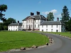
| |||
| Glasgow Road Municipal Buildings And Gatepiers | 55°56′46″N 4°34′02″W | Category B | 24881 | 
| |||
| High Street, Dumbarton Riverside Parish Church, Cemetery Walls And Gateways | 55°56′35″N 4°34′02″W | Category A | 24885 | 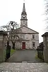
| |||
| High Street, Glencairn Tenement (Gas Board Offices) | 55°56′35″N 4°34′17″W | Category B | 24887 | 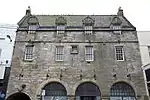
| |||
| Kirktonhill 6, 8 Dixon Drive | 55°56′27″N 4°34′44″W | Category C(S) | 24893 | Upload Photo | |||
| West Bridgend, Levenford House | 55°56′41″N 4°34′45″W | Category A | 24916 | 
| |||
| Kirktonhill Helenslee Road Keil School (Formerly Helenslee) | 55°56′29″N 4°35′06″W | Category B | 24896 | Upload Photo | |||
| Latta Street, Hartfield House | 55°56′52″N 4°33′40″W | Category C(S) | 24903 | Upload Photo | |||
| Strathleven Place St Patrick's Rc Church, Tower And Gatepiers | 55°56′44″N 4°33′51″W | Category B | 24914 | 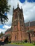
| |||
| Strathleven Place Drumoyne | 55°56′44″N 4°33′49″W | Category B | 24915 | Upload Photo | |||
| Dovecot, Strathleven | 55°58′11″N 4°34′13″W | Category A | 823 | 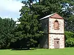
| |||
| Leven Street, United Reformed Church Including Boundary Wall And Railings | 55°56′35″N 4°33′38″W | Category C(S) | 50543 | Upload Photo | |||
| 67, 69 Glasgow Road | 55°56′37″N 4°33′34″W | Category C(S) | 24883 | Upload Photo | |||
| Helenslee Road Keil School Technical Block (Formerly Helenslee Stables) | 55°56′37″N 4°34′58″W | Category B | 24897 | Upload Photo | |||
| West Bridgend, West Kirk | 55°56′45″N 4°34′45″W | Category B | 24920 | Upload Photo |
Key
The scheme for classifying buildings in Scotland is:
- Category A: "buildings of national or international importance, either architectural or historic; or fine, little-altered examples of some particular period, style or building type."[1]
- Category B: "buildings of regional or more than local importance; or major examples of some particular period, style or building type, which may have been altered."[1]
- Category C: "buildings of local importance; lesser examples of any period, style, or building type, as originally constructed or moderately altered; and simple traditional buildings which group well with other listed buildings."[1]
In March 2016 there were 47,288 listed buildings in Scotland. Of these, 8% were Category A, and 50% were Category B, with the remaining 42% being Category C.[2]
Notes
- Sometimes known as OSGB36, the grid reference (where provided) is based on the British national grid reference system used by the Ordnance Survey.
• "Guide to National Grid". Ordnance Survey. Retrieved 12 December 2007.
• "Get-a-map". Ordnance Survey. Retrieved 17 December 2007. - Historic Environment Scotland assign a unique alphanumeric identifier to each designated site in Scotland, for listed buildings this always begins with "LB", for example "LB12345".
References
- All entries, addresses and coordinates are based on data from Historic Scotland. This data falls under the Open Government Licence
- "What is Listing?". Historic Environment Scotland. Retrieved 29 May 2018.
- Scotland's Historic Environment Audit 2016 (PDF). Historic Environment Scotland and the Built Environment Forum Scotland. pp. 15–16. Retrieved 29 May 2018.
This article is issued from Wikipedia. The text is licensed under Creative Commons - Attribution - Sharealike. Additional terms may apply for the media files.