List of listed buildings in Kilmacolm, Inverclyde
List
| Name | Location | Date Listed | Grid Ref. [note 1] | Geo-coordinates | Notes | LB Number [note 2] | Image |
|---|---|---|---|---|---|---|---|
| Finlaystone House, Port Glasgow Road, By Langbank | 55°55′43″N 4°37′09″W | Category A | 13641 | 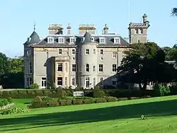
| |||
| Balrossie With Annex, Ornamental Outbuilding, Ancillary Building, Terraces, Steps, Gatepiers, Gates And Railings | 55°53′16″N 4°39′10″W | Category B | 49972 |  Upload Photo | |||
| Bridge Of Weir, 28 Quarrier's Village, (Sabbath School Home) | 55°52′03″N 4°37′11″W | Category C(S) | 50588 | 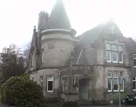
| |||
| Bridge Of Weir Hospital Main Block Including Chapel | 55°51′48″N 4°36′48″W | Category B | 13232 | Upload Photo | |||
| "Overton", Glen Road, Kilmacolm | 55°53′46″N 4°37′03″W | Category C(S) | 12457 | Upload Photo | |||
| Duchal House, Strathgryfe, By Kilmacolm | 55°52′37″N 4°38′01″W | Category A | 12463 | Upload Photo | |||
| Bridge Of Weir, 17 Quarrier's Village, 'Alan Dick Home' | 55°52′04″N 4°37′03″W | Category C(S) | 50584 | Upload Photo | |||
| Bridge Of Weir, 34 Quarrier's Village, (Glenfarg) | 55°52′03″N 4°36′45″W | Category C(S) | 50586 | Upload Photo | |||
| Kilmacolm Cemetery, Headstone For James Reid | 55°54′06″N 4°38′03″W | Category B | 51677 | Upload Photo | |||
| Kilmacolm Parish Church ("Old Kirk"), Main Street, Kilmacolm | 55°53′42″N 4°37′37″W | Category B | 12447 | 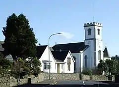
| |||
| Kidston Hall, Port Glasgow Road, Kilmacolm | 55°53′43″N 4°37′38″W | Category C(S) | 12458 | 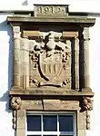
| |||
| Knockbuckle Road, Shallott, St Columba's Junior School With Terrace, Statue, Boundary Wall, Gatepiers And Gates | 55°53′32″N 4°38′09″W | Category B | 50020 | Upload Photo | |||
| Quarrier's Village, Faith Avenue, Homelea | 55°52′00″N 4°36′59″W | Category C(S) | 50021 | Upload Photo | |||
| The Cross And Lochwinnoch Road, Old Primary School With Boundary Wall | 55°53′37″N 4°37′38″W | Category C(S) | 50022 | 
| |||
| Bridge Of Weir, 45 Quarrier's Village, (Bethesda') | 55°52′00″N 4°37′02″W | Category C(S) | 50585 | Upload Photo | |||
| Bridge Of Weir, 14 Quarrier's Village, 'Overtoun' | 55°52′02″N 4°37′08″W | Category C(S) | 50587 | Upload Photo | |||
| Bridge Of Weir, 48 Quarrier's Village, The Marcus Humphrey House (Former Elise Hospital) | 55°52′04″N 4°37′15″W | Category C(S) | 50589 | Upload Photo | |||
| "Windyhill", Rowantreehill Road Kilmacolm | 55°53′24″N 4°37′13″W | Category A | 12450 | 
| |||
| Quarrier's Village, Mount Zion Church, Including Cemetery And Boundary Walls | 55°52′07″N 4°37′04″W | Category B | 48940 | 
| |||
| St. Columba's (Formerly St. James's) Church Of Scotland Duchal Road, Kilmacolm | 55°53′35″N 4°37′37″W | Category A | 12448 | Upload Photo | |||
| "Rowantreehill", Rowantreehill Road, Kilmacolm | 55°53′26″N 4°37′15″W | Category B | 12449 | Upload Photo | |||
| "Hazelhope", Gryffe Road, Kilmacolm | 55°53′13″N 4°37′24″W | Category C(S) | 12454 | Upload Photo | |||
| Lodge Of Auchenbothie House, Port Glasgow Road, By Kilmacolm | 55°54′00″N 4°38′16″W | Category B | 12461 | Upload Photo | |||
| Stable Block With Coachman's Cottage, Etc., At Duchal House | 55°52′37″N 4°38′06″W | Category B | 12464 | Upload Photo | |||
| Hope Lodge, ( Originally Lodge To Bridge Of Weir Hospital) | 55°51′47″N 4°36′23″W | Category B | 13230 | Upload Photo | |||
| "Greystones", Houston Road, Kilmacolm | 55°53′13″N 4°37′01″W | Category B | 12453 | Upload Photo | |||
| "Nether Knockbuckle", Knockbuckle, Kilmacolm | 55°53′33″N 4°38′44″W | Category B | 12456 | Upload Photo | |||
| Auchenbothie House, (Former Old Folks Home), Port Glasgow Road, By Kilmacolm | 55°54′12″N 4°38′27″W | Category B | 12460 | 
| |||
| "Cloak", (Formerly "Mosside"), Cloak Road, By Kilmacolm | 55°54′46″N 4°38′12″W | Category B | 12462 | Upload Photo | |||
| Former R.C. "Bishop's House", (Formerly "Miyanoshta") Porterfield Road, Kilmacolm | 55°53′20″N 4°37′12″W | Category B | 12451 | 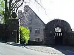
| |||
| Craigbet, By Torr Road, Bridge Of Weir | 55°51′51″N 4°36′23″W | Category B | 13047 | Upload Photo | |||
| "Knapps House", Houston Road, Kilmacolm | 55°53′12″N 4°36′47″W | Category B | 12452 | Upload Photo | |||
| "Den O' Gryffe", Knockbuckle Road, Kilmacolm | 55°53′35″N 4°38′51″W | Category B | 12455 | Upload Photo | |||
| "Water Yetts", Finlaystone Road, Kilmacolm | 55°54′00″N 4°37′40″W | Category B | 12459 | Upload Photo | |||
| Glencairn Road, Old Church Manse | 55°53′34″N 4°37′20″W | Category C(S) | 50019 | Upload Photo |
Key
The scheme for classifying buildings in Scotland is:
- Category A: "buildings of national or international importance, either architectural or historic; or fine, little-altered examples of some particular period, style or building type."[1]
- Category B: "buildings of regional or more than local importance; or major examples of some particular period, style or building type, which may have been altered."[1]
- Category C: "buildings of local importance; lesser examples of any period, style, or building type, as originally constructed or moderately altered; and simple traditional buildings which group well with other listed buildings."[1]
In March 2016 there were 47,288 listed buildings in Scotland. Of these, 8% were Category A, and 50% were Category B, with the remaining 42% being Category C.[2]
Notes
- Sometimes known as OSGB36, the grid reference (where provided) is based on the British national grid reference system used by the Ordnance Survey.
• "Guide to National Grid". Ordnance Survey. Retrieved 12 December 2007.
• "Get-a-map". Ordnance Survey. Retrieved 17 December 2007. - Historic Environment Scotland assign a unique alphanumeric identifier to each designated site in Scotland, for listed buildings this always begins with "LB", for example "LB12345".
References
- All entries, addresses and coordinates are based on data from Historic Scotland. This data falls under the Open Government Licence
- "What is Listing?". Historic Environment Scotland. Retrieved 29 May 2018.
- Scotland's Historic Environment Audit 2016 (PDF). Historic Environment Scotland and the Built Environment Forum Scotland. pp. 15–16. Retrieved 29 May 2018.
This article is issued from Wikipedia. The text is licensed under Creative Commons - Attribution - Sharealike. Additional terms may apply for the media files.