List of listed buildings in Kincardine-In-Menteith, Stirling
List
| Name | Location | Date Listed | Grid Ref. [note 1] | Geo-coordinates | Notes | LB Number [note 2] | Image |
|---|---|---|---|---|---|---|---|
| Blair Drummond House West Lodge | 56°10′06″N 4°03′05″W | Category C(S) | 8420 |  Upload Photo | |||
| Blair Drummond House East Lodge | 56°09′54″N 4°01′48″W | Category B | 8143 | Upload Photo | |||
| Meiklewood Bridge Over River Forth | 56°08′15″N 4°03′00″W | Category C(S) | 8147 | Upload Photo | |||
| Drip Old Bridge - Tollhouse | 56°08′14″N 3°58′53″W | Category C(S) | 8148 | Upload Photo | |||
| East Cambusdrenny Farmhouse | 56°07′30″N 3°59′52″W | Category C(S) | 8150 | Upload Photo | |||
| Blair Drummond Corner | 56°09′46″N 4°03′42″W | Category B | 13690 | Upload Photo | |||
| Kincardine Graveyard | 56°09′51″N 4°03′39″W | Category B | 8410 | Upload Photo | |||
| Blair Drummond House Including Terrace With Urns Etc | 56°09′59″N 4°02′38″W | Category B | 8414 | 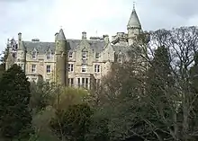
| |||
| Blair Drummond House - Cottage To S. Of Stables | 56°09′59″N 4°02′42″W | Category C(S) | 8416 | Upload Photo | |||
| Mrs. Thomson, Hillview, Thornhill | 56°10′25″N 4°09′20″W | Category B | 8131 | Upload Photo | |||
| Norrieston House And Heatherlea Thornhill | 56°10′27″N 4°08′35″W | Category C(S) | 8139 | Upload Photo | |||
| East Moss-Side Bridge Over Goodie Water | 56°10′01″N 4°10′04″W | Category C(S) | 8140 | Upload Photo | |||
| Blair Drummond House Mill Of Torr, Ruins Of Mill | 56°09′56″N 4°01′44″W | Category C(S) | 8144 | Upload Photo | |||
| Inn, Drip Bridge By Stirling | 56°08′15″N 3°58′54″W | Category C(S) | 8149 | Upload Photo | |||
| Blair Drummond House - Ice House Approx. 100 Yds. N. Of House | 56°10′03″N 4°02′38″W | Category B | 8417 | Upload Photo | |||
| Blair Drummond House - Fountainhead, Approx. 300 Yds. S.W. Of Stable Block | 56°09′57″N 4°02′53″W | Category B | 8419 | Upload Photo | |||
| Blairdrummond School, Robertson's Lane, Blairdrummond Moss | 56°08′40″N 4°02′02″W | Category B | 8146 | 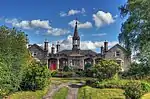
| |||
| Barn At Rear Of Menteith House Main Street, Thornhill | 56°10′26″N 4°09′02″W | Category C(S) | 8135 | Upload Photo | |||
| 37, 39 Main Street Thornhill | 56°10′26″N 4°09′00″W | Category C(S) | 8136 | Upload Photo | |||
| Muschet Tombstone, Burnbank | 56°09′50″N 4°04′47″W | Category C(S) | 8151 | Upload Photo | |||
| Loch-Hills Cottage | 56°09′46″N 4°03′46″W | Category B | 8412 | Upload Photo | |||
| Blair Drummond Corner, Sawmill | 56°09′48″N 4°03′44″W | Category C(S) | 8413 | Upload Photo | |||
| Parish Church, Kincardine | 56°09′54″N 4°03′51″W | Category A | 8431 | 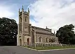
| |||
| Kincardine School | 56°09′55″N 4°03′54″W | Category C(S) | 8432 | Upload Photo | |||
| Craighead, Farmhouse | 56°09′25″N 4°06′47″W | Category C(S) | 8130 | Upload Photo | |||
| Crown Hotel, Main Street, Thornhill | 56°10′26″N 4°09′03″W | Category B | 8132 | 
| |||
| Blairhill, Main Street, Thornhill | 56°10′28″N 4°08′35″W | Category B | 8133 | Upload Photo | |||
| Blair Drummond House - Store, Approx. 100 Yds. S.W. Of Stable Block | 56°09′58″N 4°02′48″W | Category C(S) | 8418 | Upload Photo | |||
| Blair Drummond House Obelisk | 56°09′49″N 4°03′18″W | Category B | 8422 | Upload Photo | |||
| Ochtertyre House, Walled Garden | 56°09′29″N 4°00′39″W | Category C(S) | 8145 | Upload Photo | |||
| Blair Drummond House - Stables (Part Now Piggeries) | 56°10′00″N 4°02′42″W | Category B | 8415 | Upload Photo | |||
| Blairhoyle Masonic Lodge Main Street Thornhill | 56°10′25″N 4°09′10″W | Category C(S) | 8134 | 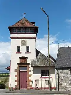
| |||
| Norrieston Church Thornhill | 56°10′28″N 4°08′37″W | Category B | 8138 | 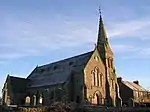
| |||
| West Moss-Side Farmhouse | 56°10′10″N 4°10′40″W | Category B | 8141 | Upload Photo | |||
| Netherton Bridge Over Goodie Water | 56°09′45″N 4°09′28″W | Category C(S) | 8142 | Upload Photo | |||
| Bridge Over Carrat Burn (Near Saughs Cottage) | 56°08′57″N 4°00′27″W | Category C(S) | 48976 | Upload Photo | |||
| Kincardine Manse (Now Captain Sherriff) | 56°09′48″N 4°04′02″W | Category B | 8411 | Upload Photo | |||
| Blair Drummond House Cuthill Brae Cottage | 56°10′07″N 4°03′10″W | Category C(S) | 8421 | Upload Photo | |||
| Drip Old Bridge Over River Forth | 56°08′14″N 3°58′50″W | Category A | 6725 | 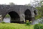 |
Key
The scheme for classifying buildings in Scotland is:
- Category A: "buildings of national or international importance, either architectural or historic; or fine, little-altered examples of some particular period, style or building type."[1]
- Category B: "buildings of regional or more than local importance; or major examples of some particular period, style or building type, which may have been altered."[1]
- Category C: "buildings of local importance; lesser examples of any period, style, or building type, as originally constructed or moderately altered; and simple traditional buildings which group well with other listed buildings."[1]
In March 2016 there were 47,288 listed buildings in Scotland. Of these, 8% were Category A, and 50% were Category B, with the remaining 42% being Category C.[2]
Notes
- Sometimes known as OSGB36, the grid reference (where provided) is based on the British national grid reference system used by the Ordnance Survey.
• "Guide to National Grid". Ordnance Survey. Retrieved 12 December 2007.
• "Get-a-map". Ordnance Survey. Retrieved 17 December 2007. - Historic Environment Scotland assign a unique alphanumeric identifier to each designated site in Scotland, for listed buildings this always begins with "LB", for example "LB12345".
References
- All entries, addresses and coordinates are based on data from Historic Scotland. This data falls under the Open Government Licence
- "What is Listing?". Historic Environment Scotland. Retrieved 29 May 2018.
- Scotland's Historic Environment Audit 2016 (PDF). Historic Environment Scotland and the Built Environment Forum Scotland. pp. 15–16. Retrieved 29 May 2018.
This article is issued from Wikipedia. The text is licensed under Creative Commons - Attribution - Sharealike. Additional terms may apply for the media files.