NUTS statistical regions of Ireland
Ireland uses the Nomenclature of Territorial Units for Statistics (NUTS) geocode standard for referencing country subdivisions for statistical purposes.[1] The standard is developed and regulated by the European Union. The NUTS standard is instrumental in delivering European Structural and Investment Funds. The NUTS code for Ireland is IE and a hierarchy of three levels is established by Eurostat. A further level of geographic organisation, the local administrative unit (LAU), in Ireland is the local electoral area.
Overview
| Level | Subdivisions |
|---|---|
| NUTS 1 | 1 |
| NUTS 2 statistical regions | 3 |
| NUTS 3 statistical regions | 8 |
| Local administrative units | 166 |
NUTS levels 1, 2 and 3
The most recent revision of NUTS regions was made in 2016 and took effect in 2018.[2] The eligibility of regions for funding under the European Regional Development Fund and the European Social Fund Plus was revised in 2021. NUTS 2 Regions may be classified as less developed regions, transition regions, or more developed regions.[3]
| NUTS 1 | Code | NUTS 2 | Code | Status | NUTS 3 | Code | Local government areas |
|---|---|---|---|---|---|---|---|
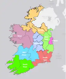
| Éire / Ireland | IE0 | Northern and Western Region | IE04 | Transition | Border | IE041 | Cavan, Donegal, Leitrim, Monaghan, Sligo |
| West | IE042 | Mayo, Roscommon, Galway and Galway City | |||||
| Southern Region | IE05 | More developed | Mid-West | IE051 | Clare, Tipperary, Limerick City and County | ||
| South-East | IE052 | Carlow, Kilkenny, Wexford, Waterford City and County | |||||
| South-West | IE053 | Kerry, Cork and Cork City | |||||
| Eastern and Midland Region | IE06 | More developed | Dublin | IE061 | Dublin City, Dún Laoghaire–Rathdown, Fingal and South Dublin | ||
| Mid-East | IE062 | Kildare, Meath, Wicklow, Louth | |||||
| Midland | IE063 | Laois, Longford, Offaly, Westmeath |
Demographic statistics by NUTS 3 region
| Region | Population (2022)[4] | Area (km2) | Population density | % of population |
|---|---|---|---|---|
| Border | 417,260 | 11,516 | 36 | 8.14% |
| West | 483,677 | 14,289 | 34 | 9.44% |
| Mid-West | 500,524 | 10,511 | 48 | 9.77% |
| South-East | 456,228 | 7,198 | 63 | 8.9% |
| South-West | 736,489 | 12,312 | 60 | 14.37% |
| Dublin | 1,450,701 | 926 | 1,567 | 28.31% |
| Mid-East | 761,858 | 6,891 | 111 | 14.87% |
| Midland | 316,799 | 6,651 | 48 | 6.18% |
| Ireland | 5,123,536 | 70,294 | 73 | 100% |
Local administrative units
The local administrative units in Ireland are the local electoral areas.[5] These are subdivisions of local government areas used for local elections. In counties outside Dublin and in the cities and counties, they also form the basis of municipal districts within local authorities.
Regional Assemblies
Each of the three NUTS 2 regions has a Regional Assembly. These are divided into strategic planning areas, which correspond to the NUTS 3 regions. Prior to 2014, the eight NUTS 3 regions had Regional Authorities. The 2014 act abolished these and transferred their functions to the Regional Assemblies.[6] Assembly members are nominated by constituent local authorities from among their elected councillors.
See also
Sources
References
- "Revision to the Irish NUTS2 and NUTS3 regions". cso.ie.
- Commission Regulation (EU) 2016/2066 of 21 November 2016 amending the annexes to Regulation (EC) No 1059/2003 of the European Parliament and of the Council on the establishment of a common classification of territorial units for statistics (NUTS)
- Commission Implementing Decision (EU) 2021/1130 of 5 July 2021 setting out the list of regions eligible for funding from the European Regional Development Fund and the European Social Fund Plus and of Member States eligible for funding from the Cohesion Fund for the period 2021-2027 (notified under document C(2021) 4894)
- "FP005 Components of Population Change 2016 to 2022". 23 June 2022. Retrieved 12 March 2023.
- "Correspondence between the NUTS levels and the national administrative units". Eurostat. 11 June 2020. Retrieved 14 January 2022.
- Local Government Act 1991 (Regional Authorities) (Amendment) Order 2014 (S.I. No. 228 of 2014). Signed on 29 May 2014. Statutory Instrument of the Government of Ireland. Retrieved from Irish Statute Book on 24 March 2019.; Local Government Act 1991 (Regional Assemblies) (Establishment) Order 2014 (S.I. No. 573 of 2014). Signed on 16 December 2014. Statutory Instrument of the Government of Ireland. Retrieved from Irish Statute Book on 24 March 2019.