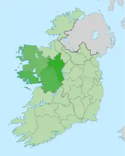
West Region, Ireland
The West is a strategic planning area within the Northern and Western Region in Ireland. It is a NUTS Level III statistical region of Ireland (coded IE042)[1] under the Eurostat classification. It consists of the counties of Galway, Mayo and Roscommon, and the city of Galway. The West spans 13,801 km2 (20% of the total area of the state) and as of the 2022 census has a population of 485,966.[2]
West | |
|---|---|
 The West of Ireland with each local government area highlighted. | |
| Country | |
| Region | Northern and Western |
The region is located on the western seaboard of Ireland with the Atlantic Ocean to the west and the River Shannon delimiting the region to the east. The West Region is largely rural, with only 30% of its population living in urban areas. It is noted for its continuance of Irish traditions, such as the Irish language in the region's Gaeltacht areas.
Regional Assembly
The constituent local authorities are the councils of the counties of Galway, Mayo and Roscommon and the city Galway, which each send representatives to the Northern and Western Regional Assembly, forming the West Strategic Planning Area Committee.[3]
Former Regional Authority
From 1994 to 2014, the West Region was administered by the West Regional Authority, which consisted of 28 elected representatives including the region's representative on the European Union Committee of the Regions. These representatives met once a month and were nominated from the four administrative councils of the region:[4]
- Galway City Council (6)
- Galway County Council (7)
- Mayo County Council (7)
- Roscommon County Council (6)
In 2014, the Regional Authorities were dissolved and their functions were transferred to the Regional Assemblies.[5]
Demographics
According to the 2022 census, the region had a population of 485,966, which constitutes 9.43% of the national population.[2] Its population density was 35 persons per km2. The population of the regional capital, Galway City, was 85,910.
Economy
According to Eurostat figures for 2012, the region has GDP of €13.802 bn and a GDP per capita of €31,500.[6]
Tourism in the region is bolstered by its geography, with it attracting tourists from across Ireland and elsewhere, with inland rivers, lakes, mountains and plains, along with off shore islands, a large number of beaches, and its rugged coastline amongst natural attractions.
Transport
The Ireland West Airport Knock is an international airport in the region which is served by flights to the United Kingdom, and continental Europe. Mainline rail services operate from both Galway and Mayo to Dublin. The M6 motorway, connecting Galway to Dublin, was completed in 2009.[7] The M17 motorway from Shannon to the M6 opened in 2010 and its short continuation north to Tuam (as the M18 motorway) opened in 2017.
The Western Railway Corridor re-opened in 2010 as far as Athenry, a junction with the Dublin-Galway line.
Urban areas
A list of the largest urban areas in the West Region. County capitals are shown in bold.
| Rank | Town | County | Population (2022 census)[2] |
|---|---|---|---|
| 1 | Galway | Galway | 85,910 |
| 2 | Castlebar | Mayo | 13,054 |
| 3 | Ballina | Mayo | 10,556 |
| 4 | Tuam | Galway | 9,647 |
| 5 | Westport | Mayo | 6,872 |
| 6 | Ballinasloe | Galway | 6,597 |
| 7 | Roscommon | Roscommon | 6,555 |
| 8 | Loughrea | Galway | 6,322 |
| 9 | Oranmore | Galway | 5,819 |
| 10 | Athenry | Galway | 4,603 |
| 11 | Claremorris | Mayo | 3,857 |
| 12 | Ballinrobe | Mayo | 3,148 |
| 13 | Boyle | Roscommon | 2,915 |
References
- "Revision to the Irish NUTS2 and NUTS3 regions". cso.ie.
- "Census 2022 - F1004A - Population". Central Statistics Office Census 2022 Reports. Central Statistics Office Ireland. August 2023. Retrieved 16 September 2023.
- Local Government Act 1991 (Regional Assemblies) (Establishment) Order 2014 (S.I. No. 573 of 2014), "42. A regional assembly shall establish a strategic planning area committee in respect of each strategic planning area within the region, specified in column (2) of Schedule 3, consisting of the members of the regional assembly appointed by the constituent local authorities specified in column (3) of that Schedule opposite the mention in the said column (2) of the area, and of persons who are not members of the regional assembly, to perform functions, in respect of such area, in relation to the regional spatial and economic strategy in accordance with Chapter III of Part II of the Act of 2000 and any regulations or directions under that Act.". Signed on 16 December 2014. Statutory Instrument of the Government of Ireland. Retrieved from Irish Statute Book on 17 March 2022.
- Local Government Act 1991 (Regional Authorities) (Establishment) Order 1993 (S.I. No. 394 of 1993). Signed on 20 December 1993. Statutory Instrument of the Government of Ireland. Retrieved from Irish Statute Book on 17 March 2022.
- Local Government Act 1991 (Regional Authorities) (Amendment) Order 2014 (S.I. No. 228 of 2014). Signed on 29 May 2014. Statutory Instrument of the Government of Ireland. Retrieved from Irish Statute Book on 19 January 2022.
- "Eurostat - Data Explorer". Archived from the original on 6 October 2014. Retrieved 6 October 2014.
- "Galway/Dublin motorway in operation". RTÉ News. 18 December 2009. Retrieved 17 September 2010.