Loburn
Loburn is a rural community in North Canterbury, New Zealand. It is located ten kilometres northwest of Rangiora and nearly 50 kilometres north of Christchurch.
Loburn | |
|---|---|
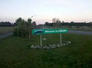 Welcome sign to Loburn, looking east towards Loburn School (2013). | |
| Coordinates: 43°15′S 172°32′E | |
| Country | New Zealand |
| Region | Canterbury |
| Territorial authority | Waimakariri District |
| Ward | Rangiora-Ashley Ward |
| Community | Rangiora-Ashley Community |
| Electorates |
|
| Government | |
| • Territorial Authority | Waimakariri District Council |
| • Regional council | Environment Canterbury |
| • Mayor of Waimakariri | Dan Gordon |
| • Kaikōura MP | Stuart Smith |
| • Te Tai Tonga MP | Tākuta Ferris |
| Area | |
| • Rural | 89.43 km2 (34.53 sq mi) |
| Elevation (Loburn Abbey Airfield)[3] | 116 m (380 ft) |
| Population (June 2022)[4] | |
| • Rural | 2,420 |
| • Density | 27/km2 (70/sq mi) |
| Time zone | UTC+12 (NZST) |
| • Summer (DST) | UTC+13 (NZDT) |
| Postcode | 7472 |
| Area code | 03 |
Loburn is a small community, with no shops. Local industries include a cheese factory and orchards. Farms in the community include those raising sheep, cattle and emu.[5]
Geography
Loburn is located close to the northernmost extreme of the Canterbury Plains. It is bounded to the south and west by the Ashley and Okuku rivers, respectively. To the north it is bounded by the foothills, Mount Grey / Maukatere (933m)[6] and Mt Karetu (972m)[7] and bounded to the east by the Ashley forest.
The Loburn-Ashley fault zone is located from the northern banks of the Ashley River through to about Hodgsons road in the north, it runs parallel to the Ashley river. The Loburn fault, which runs along the south side of Hodgsons Road, is responsible for various terraced abandoned stream channels, wedge structures and scarps, notably Round Hill.[8] The topography in Loburn is generally flat with gently rolling hills, altitude gradually decreases southwards from the foothills.
Demographics
The Loburn statistical area covers 89.43 km2 (34.53 sq mi).[2] It had an estimated population of 2,420 as of June 2022,[4] with a population density of 27.06 people per km2.
| Year | Pop. | ±% p.a. |
|---|---|---|
| 1901[9] | 537 | — |
| 1996[10] | 1,032 | +0.69% |
| 2001[10] | 1,197 | +3.01% |
| 2006[11] | 1,338 | +2.25% |
| 2013[11] | 1,941 | +5.46% |
| 2018[11] | 2,175 | +2.30% |
Loburn had a population of 2,175 at the 2018 New Zealand census, an increase of 234 people (12.1%) since the 2013 census, and an increase of 837 people (62.6%) since the 2006 census. There were 735 households, comprising 1,098 males and 1,077 females, giving a sex ratio of 1.02 males per female. The median age was 45.4 years (compared with 37.4 years nationally), with 414 people (19.0%) aged under 15 years, 339 (15.6%) aged 15 to 29, 1,149 (52.8%) aged 30 to 64, and 273 (12.6%) aged 65 or older.
Ethnicities were 95.7% European/Pākehā, 6.2% Māori, 1.4% Pasifika, 1.5% Asian, and 1.8% other ethnicities. People may identify with more than one ethnicity.
The percentage of people born overseas was 20.7, compared with 27.1% nationally.
Although some people chose not to answer the census's question about religious affiliation, 57.4% had no religion, 32.7% were Christian, 0.3% were Hindu, 0.3% were Buddhist and 1.7% had other religions.
Of those at least 15 years old, 339 (19.3%) people had a bachelor's or higher degree, and 270 (15.3%) people had no formal qualifications. The median income was $36,900, compared with $31,800 nationally. 414 people (23.5%) earned over $70,000 compared to 17.2% nationally. The employment status of those at least 15 was that 942 (53.5%) people were employed full-time, 348 (19.8%) were part-time, and 57 (3.2%) were unemployed.[11]
Education
Loburn has two schools.
Loburn School (est. 1869) is a decile 9 state co-educational primary school[12] with a role of 159 students (as of April 2023).[13]
North Loburn School (est. 1882) is a decile 9 state co-educational primary school[14] with a role of 101 students (as of April 2023).[13]
References
- "Find my Electorate | Electoral Commission". Elections.org.nz. Archived from the original on 8 February 2013. Retrieved 1 February 2014.
- "ArcGIS Web Application". statsnz.maps.arcgis.com. Retrieved 29 August 2021.
- Loburn Abbey Airfield Flyin (16 February 2013). "Loburn Abbey fly-in". Aircraft-r-us.com. Retrieved 1 February 2014.
- "Population estimate tables - NZ.Stat". Statistics New Zealand. Retrieved 25 October 2022.
- Cross, Tracy-Anne et al. 2005 p.46 North Canterbury: An Analysis of the Current Economic Base of the Region Archived 14 October 2008 at the Wayback Machine
- "Mount Grey/Maukatere, Canterbury". topomap.co.nz.
- "Mount Karetu, Canterbury". topomap.co.nz.
- "Paleoseismicity of the Ashley and Loburn Faults, North Canterbury, New Zealand. (pages 42-54)" (PDF). Earthquake Commission Research Foundation. Retrieved 16 December 2013.
- Cyclopedia Company Limited. "Loburn | NZETC". Nzetc.victoria.ac.nz. Retrieved 1 February 2014.
- "Loburn Community Profile(published)". .stats.govt.nz. 30 May 2003. Retrieved 1 February 2014.
- "Statistical area 1 dataset for 2018 Census". Statistics New Zealand. March 2020. Loburn (313400). 2018 Census place summary: Loburn
- "Loburn School Website". Loburn.ultranet.school.nz. 17 December 2013. Archived from the original on 13 November 2013. Retrieved 1 February 2014.
- "New Zealand Schools Directory". New Zealand Ministry of Education. Retrieved 12 December 2022.
- "North Loburn School Website". Northloburn.school.nz. Retrieved 1 February 2014.