Fernside, New Zealand
Fernside is a small rural community in the Waimakariri District, New Zealand. In 1901, Fernside had (with its neighbourhood) a population of 550.[3] As of the 2006 New Zealand census, Fernside has a population of 1491.[4]
Fernside | |
|---|---|
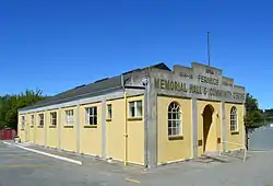 Memorial hall and community centre | |
| Coordinates: 43.31°S 172.54°E | |
| Country | New Zealand |
| Region | Canterbury |
| Territorial authority | Waimakariri District |
| Ward | Rangiora-Ashley Ward |
| Community | Rangiora-Ashley Community |
| Electorates |
|
| Government | |
| • Territorial Authority | Waimakariri District Council |
| • Regional council | Environment Canterbury |
| • Mayor of Waimakariri | Dan Gordon |
| • Waimakariri MP | Matthew Doocey |
| • Te Tai Tonga MP | Tākuta Ferris |
| Area | |
| • Total | 41.48 km2 (16.02 sq mi) |
| Population (June 2022)[2] | |
| • Total | 1,500 |
| • Density | 36/km2 (94/sq mi) |
| Time zone | UTC+12 (NZST) |
| • Summer (DST) | UTC+13 (NZDT) |
| Postcode | 7471 |
| Area code | 03 |
| Local iwi | Ngāi Tahu |
Demographics
Fernside statistical area covers 41.48 km2 (16.02 sq mi)[1] and had an estimated population of 1,500 as of June 2022,[2] with a population density of 36 people per km2.
| Year | Pop. | ±% p.a. |
|---|---|---|
| 2006 | 936 | — |
| 2013 | 1,224 | +3.91% |
| 2018 | 1,326 | +1.61% |
| Source: [5] | ||
Fernside had a population of 1,326 at the 2018 New Zealand census, an increase of 102 people (8.3%) since the 2013 census, and an increase of 390 people (41.7%) since the 2006 census. There were 456 households, comprising 654 males and 672 females, giving a sex ratio of 0.97 males per female. The median age was 45.0 years (compared with 37.4 years nationally), with 258 people (19.5%) aged under 15 years, 204 (15.4%) aged 15 to 29, 666 (50.2%) aged 30 to 64, and 195 (14.7%) aged 65 or older.
Ethnicities were 95.2% European/Pākehā, 8.6% Māori, 0.5% Pasifika, 1.1% Asian, and 1.6% other ethnicities. People may identify with more than one ethnicity.
The percentage of people born overseas was 12.4, compared with 27.1% nationally.
Although some people chose not to answer the census's question about religious affiliation, 53.6% had no religion, 36.4% were Christian, 0.2% were Hindu and 1.1% had other religions.
Of those at least 15 years old, 186 (17.4%) people had a bachelor's or higher degree, and 165 (15.4%) people had no formal qualifications. The median income was $36,500, compared with $31,800 nationally. 255 people (23.9%) earned over $70,000 compared to 17.2% nationally. The employment status of those at least 15 was that 549 (51.4%) people were employed full-time, 228 (21.3%) were part-time, and 24 (2.2%) were unemployed.[5]
Education
Fernside School is Fernside's only school, and was established in 1864.[6] It is a decile 10 state co-educational full primary, with 276 students (as of April 2023).[7]
Climate
The average temperature in summer is 16.2, and in winter is 6.4.[8]
| Month | Normal temperature |
|---|---|
| January | 16.7 °C |
| February | 16.3 °C |
| March | 15.0 °C |
| April | 12.1 °C |
| May | 8.8 °C |
| June | 6.3 °C |
| July | 5.8 °C |
| August | 7.1 °C |
| September | 9.4 °C |
| October | 11.4 °C |
| November | 13.5 °C |
| December | 15.5 °C |
References
- "ArcGIS Web Application". statsnz.maps.arcgis.com. Retrieved 17 August 2023.
- "Population estimate tables - NZ.Stat". Statistics New Zealand. Retrieved 25 October 2022.
- "FERNSIDE". THE CYCLOPEDIA OF NEW ZEALAND. Retrieved 29 November 2013.
- "Interactive Boundary Maps". Statistics New Zealand. Archived from the original on 30 October 2013. Retrieved 29 November 2013.
- "Statistical area 1 dataset for 2018 Census". Statistics New Zealand. March 2020. Fernside (313800). 2018 Census place summary: Fernside
- "Fernside School". Archived from the original on 2 December 2013. Retrieved 29 November 2013.
- "New Zealand Schools Directory". New Zealand Ministry of Education. Retrieved 12 December 2022.
- "Weather statistics for Fernside, Canterbury (New Zealand)". yr.no. Retrieved 29 November 2013.
External links
![]() Media related to Fernside, New Zealand at Wikimedia Commons
Media related to Fernside, New Zealand at Wikimedia Commons