Lodgepole, South Dakota
Lodgepole is an unincorporated community in Perkins County, South Dakota, United States.
Lodgepole, South Dakota | |
|---|---|
| Coordinates: 45°48′17″N 102°39′39″W | |
| Country | United States |
| State | South Dakota |
| County | Perkins |
| Area | |
| • Total | 36.1 sq mi (93.4 km2) |
| • Land | 36.0 sq mi (93.3 km2) |
| • Water | 0.0 sq mi (0.1 km2) |
| Elevation | 2,792 ft (851 m) |
| Population (2000) | |
| • Total | 42 |
| • Density | 1.2/sq mi (0.5/km2) |
| Time zone | UTC-7 (Mountain (MST)) |
| • Summer (DST) | UTC-6 (MDT) |
| ZIP code | 57640 |
| Area code | 605 |
| FIPS code | 46-38100[1] |
| GNIS feature ID | 1256189[2] |
The community took its name from Lodgepole Creek.[3] It is surrounded on three sides by the Grand River National Grassland, although the tracts are not contiguous.[4]
References
- "U.S. Census website". United States Census Bureau. Retrieved January 31, 2008.
- U.S. Geological Survey Geographic Names Information System: Lodgepole, South Dakota
- Federal Writers' Project (1940). South Dakota place-names, v.1-3. University of South Dakota. p. 48.
- Map of the Grand River National Grassland
Municipalities and communities of Perkins County, South Dakota, United States | ||
|---|---|---|
| City | 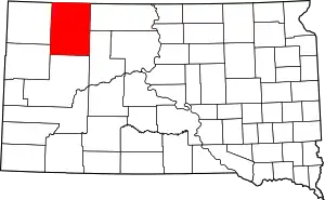 | |
| Town | ||
| Townships |
| |
| CDP | ||
| Other communities | ||
| Ghost towns | ||
| Indian reservation | ||
| Footnotes | ‡This populated place also has portions in an adjacent county or counties | |
This article is issued from Wikipedia. The text is licensed under Creative Commons - Attribution - Sharealike. Additional terms may apply for the media files.