Long Hollow, South Dakota
Long Hollow is an unincorporated community and census-designated place in Roberts County, South Dakota, United States. Its population was 265 as of the 2020 census.[4]
Long Hollow, South Dakota | |
|---|---|
 Long Hollow, South Dakota  Long Hollow, South Dakota | |
| Coordinates: 45°40′56″N 97°09′40″W | |
| Country | United States |
| State | South Dakota |
| County | Roberts |
| Area | |
| • Total | 14.55 sq mi (37.69 km2) |
| • Land | 14.43 sq mi (37.38 km2) |
| • Water | 0.12 sq mi (0.31 km2) |
| Elevation | 1,696 ft (517 m) |
| Population | |
| • Total | 265 |
| • Density | 18.36/sq mi (7.09/km2) |
| Time zone | UTC-6 (Central (CST)) |
| • Summer (DST) | UTC-5 (CDT) |
| Area code | 605 |
| GNIS feature ID | 2584559[3] |
Geography
According to the U.S. Census Bureau, the community has an area of 14.550 square miles (37.68 km2); 14.432 square miles (37.38 km2) of its area is land, and 0.118 square miles (0.31 km2) is water.[5]
References
- "ArcGIS REST Services Directory". United States Census Bureau. Retrieved October 15, 2022.
- "Census Population API". United States Census Bureau. Retrieved October 15, 2022.
- "Long Hollow Census Designated Place". Geographic Names Information System. United States Geological Survey, United States Department of the Interior.
- "U.S. Census Bureau: Long Hollow CDP, South Dakota". www.census.gov. United States Census Bureau. Retrieved January 28, 2022.
- "2010 Census Gazetteer Files - Places: South Dakota". U.S. Census Bureau. Retrieved January 28, 2017.
- "Census of Population and Housing". Census.gov. Retrieved June 4, 2016.
Municipalities and communities of Roberts County, South Dakota, United States | ||
|---|---|---|
| Cities | 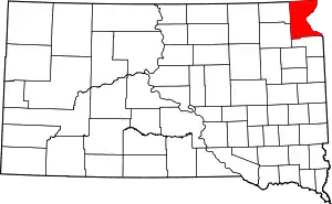 | |
| Towns | ||
| CDPs | ||
| Other communities | ||
| Townships | ||
| Indian reservation | ||
| Footnotes | ‡This populated place also has portions in an adjacent county or counties | |
This article is issued from Wikipedia. The text is licensed under Creative Commons - Attribution - Sharealike. Additional terms may apply for the media files.