Lost Creek, Kentucky
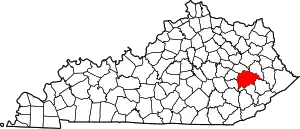
Lost Creek is an unincorporated community in Breathitt County, Kentucky. The community is centered on the intersection of Lost Creek and Troublesome Creek,[2] and the junction of Kentucky Route 476 with Kentucky Route 15 about 6 miles (9.7 km) south-southeast of Jackson.[3] Lost Creek has a post office[4] with ZIP code 41348, which opened on October 11, 1849.[5][6]
Lost Creek, Kentucky | |
|---|---|
 Lost Creek, Kentucky | |
| Coordinates: 37°28′54″N 83°19′31″W | |
| Country | United States |
| State | Kentucky |
| County | Breathitt |
| Elevation | 784 ft (239 m) |
| Time zone | UTC-5 (Eastern (EST)) |
| • Summer (DST) | UTC-4 (EDT) |
| ZIP code | 41348 |
| Area code | 606 |
| GNIS feature ID | 508507[1] |
Much of Lost Creek was destroyed in a flash-flood in July 2022.[7][8][9]
References
- "Lost Creek". Geographic Names Information System. United States Geological Survey, United States Department of the Interior.
- Google Maps 37°28'41.7" N, 83°19'22.1" W and U.S.G.S. 37.4782298, -83.3228445
- State Primary Road System: Breathitt County (PDF) (Map). Kentucky Transportation Cabinet. 2012. Retrieved June 9, 2013.
- "Lost Creek Post Office". Postal Locations. postallocations.com.
- United States Postal Service (2012). "USPS - Look Up a ZIP Code". Retrieved February 15, 2012.
- "Postmaster Finder - Post Offices by County". United States Postal Service. Retrieved April 18, 2023.
- Robertson, Campbell (October 29, 2022). "Months After the Floods, Eastern Kentucky Families Take Measure of What Was Lost". The New York Times.
- Aoyama, Andrew (April 2023). "Appalachia's Quiet Time Bombs". The Atlantic.
- Sandor, Julia (August 9, 2022). "Lost Creek residents hopeful for more help after President Biden's visit". WYMT Mountain News. Archived from the original on August 10, 2022.
This article is issued from Wikipedia. The text is licensed under Creative Commons - Attribution - Sharealike. Additional terms may apply for the media files.
