Louny District
Louny District (Czech: okres Louny) is a district in the Ústí nad Labem Region of the Czech Republic. Its capital is the town of Louny, but the most populated town is Žatec.
Louny District
Okres Louny | |
|---|---|
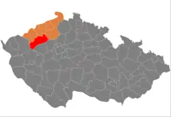 Location in the Ústí nad Labem Region within the Czech Republic | |
 | |
| Coordinates: 50°19′N 13°37′E | |
| Country | |
| Region | Ústí nad Labem |
| Capital | Louny |
| Area | |
| • Total | 1,120.97 km2 (432.81 sq mi) |
| Population (2023)[2] | |
| • Total | 87,040 |
| • Density | 78/km2 (200/sq mi) |
| Time zone | UTC+1 (CET) |
| • Summer (DST) | UTC+2 (CEST) |
| Municipalities | 70 |
| * Towns | 7 |
| * Market towns | 7 |
Administrative division
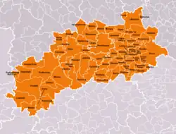
Louny District is divided into three administrative districts of municipalities with extended competence: Louny, Podbořany and Žatec.
List of municipalities
Towns are marked in bold and market towns in italics:
Bitozeves - Blatno - Blažim - Blšany - Blšany u Loun - Brodec - Břvany - Cítoliby - Čeradice - Černčice - Chlumčany - Chožov - Chraberce - Deštnice - Dobroměřice - Domoušice - Holedeč - Hříškov - Hřivice - Jimlín - Koštice - Kozly - Krásný Dvůr - Kryry - Lenešice - Libčeves - Liběšice - Libočany - Libořice - Lipno - Lišany - Líšťany - Louny - Lubenec - Měcholupy - Nepomyšl - Nová Ves - Nové Sedlo - Obora - Očihov - Opočno - Panenský Týnec - Peruc - Petrohrad - Pnětluky - Počedělice - Podbořanský Rohozec - Podbořany - Postoloprty - Raná - Ročov - Slavětín - Smolnice - Staňkovice - Toužetín - Tuchořice - Úherce - Velemyšleves - Veltěže - Vinařice - Vrbno nad Lesy - Vroutek - Vršovice - Výškov - Zálužice - Žatec - Zbrašín - Želkovice - Žerotín - Žiželice
Geography

Most of the territory is flat and has an agricultural character, only the south and northeast are hilly. The territory is located in the rain shadow of the Ore Mountains and therefore belongs to the driest regions of the country. The territory extends into five geomorphological mesoregions: Most Basin (north and centre), Rakovník Uplands (southwest), Džbán (south), Lower Eger Table (east) and Central Bohemian Uplands (northeast). The highest point of the district is a contour line on the slopes of Ostrý hill in Libčeves with an elevation of 609 m (1,998 ft), the highest peak is Velký les in Blatno with an elevation of 592 m (1,942 ft). The lowest point is the river bed of the Ohře in Koštice at 165 m (541 ft).
From the total district area of 1,121.0 km2 (432.8 sq mi), agricultural land occupies 788.4 km2 (304.4 sq mi), forests occupy 180.5 km2 (69.7 sq mi), and water area occupies 15.6 km2 (6.0 sq mi). Forests cover 16.1% of the district's area.[1]
The most important river is the Ohře, which drains almost the entire territory. Its most important tributaries are the Blšanka and Chomutovka. The largest body of water is Lenešický Pond. However, there are only a few bodies of water.
České Středohoří is a protected landscape area that extends into the district.
Demographics
|
|
| ||||||||||||||||||||||||||||||||||||||||||||||||||||||
| Source: Censuses[3][4] | ||||||||||||||||||||||||||||||||||||||||||||||||||||||||
Economy
The largest employers with headquarters in Louny District and at least 500 employees are:[5]
| Economic entity | Location | Number of employees | Main activity |
|---|---|---|---|
| Nexen Tire Europe | Bitozeves | 1,000–1,499 | Manufacture of tires |
| Koito Czech | Žatec | 1,000–1,499 | Manufacture of headlights |
| Yanfeng International Automotive Technology Czechia | Bitozeves | 500–999 | Automotive industry |
| Aisan Industry Czech | Louny | 500–999 | Automotive industry |
| Gestamp Louny | Velemyšleves | 500–999 | Automotive industry |
Žatec and its surroundings is known for its tradition of growing Saaz hops. It is a protected designation of origin.[6]
Transport
The D7 motorway from Prague to Chomutov, including the unfinished section, leads across the district. The D6 motorway from Prague to Karlovy Vary passes through the southern part of the district.
Sights

The most important monuments in the district, protected as national cultural monuments, are:[7]
- Church of Saint Nicholas in Louny
- Krásný Dvůr Castle
The best-preserved settlements and landscapes, protected as monument reservations and monument zones, are:[8]
- Žatec (includes both a monument reservation and a monument zone)
- Louny
- Soběchleby
- Stekník
- Žatec hops landscape
The most visited tourist destination is the Krásný Dvůr Castle.[9]
Notable people
References
- "Land use (as at 31 December)". Public database. Czech Statistical Office. Retrieved 2023-05-17.
- "Population of Municipalities – 1 January 2023". Czech Statistical Office. 2023-05-23.
- "Historický lexikon obcí České republiky 1869–2011 – Okres Louny" (in Czech). Czech Statistical Office. 2015-12-21. pp. 1–2.
- "Population Census 2021: Population by sex". Public Database. Czech Statistical Office. 2021-03-27.
- "Registr ekonomických subjektů". Business Register (in Czech). Czech Statistical Office. Retrieved 2023-01-19.
- "Žatecký chmel" (in Czech). Žatecký chmel. Retrieved 2021-07-26.
- "Výsledky vyhledávání: Národní kulturní památky, okres Louny". Ústřední seznam kulturních památek (in Czech). National Heritage Institute. Retrieved 2023-01-19.
- "Výsledky vyhledávání: Památkové rezervace, Památkové zóny, okres Louny". Ústřední seznam kulturních památek (in Czech). National Heritage Institute. Retrieved 2023-01-19.
- "Návštěvnost památek 2021" (in Czech). Národní informační a poradenské středisko pro kulturu. Retrieved 2023-03-20.
External links
- Louny District – profile on the Czech Statistical Office website