Lufeng, Guangdong
Lufeng, alternately romanized as Lukfung,[lower-alpha 1] is a county-level city in the southeast of Guangdong province, administered as a part of the prefecture-level city of Shanwei. It lies on the mainland on coast of the South China Sea east of Hong Kong.
Lufeng
陆丰市 Lukfung | |
|---|---|
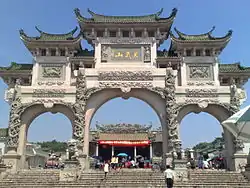 The entrance to Xuanwu Mountain in Jieshi | |
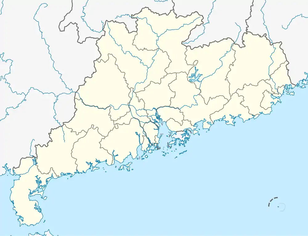 Lufeng Location in Guangdong | |
| Coordinates: 22°55′08″N 115°39′08″E | |
| Country | People's Republic of China |
| Province | Guangdong |
| Prefecture-level city | Shanwei |
| Area | |
| • Total | 1,681 km2 (649 sq mi) |
| Time zone | UTC+8 (China Standard) |
| Lufeng | |||||||||||||||||||||
|---|---|---|---|---|---|---|---|---|---|---|---|---|---|---|---|---|---|---|---|---|---|
| Simplified Chinese | 陆丰 | ||||||||||||||||||||
| Traditional Chinese | 陸豐 | ||||||||||||||||||||
| Hanyu Pinyin | Lùfēng | ||||||||||||||||||||
| Cantonese Yale | Luhkfūng | ||||||||||||||||||||
| Postal | Lukfung | ||||||||||||||||||||
| Literal meaning | Continent Abundance | ||||||||||||||||||||
| |||||||||||||||||||||
History
Under the Qing, the area was known as Lufeng County. Together with neighboring Haifeng and the now separated Luhe county now carved out from Lufeng, it formed the short-lived Hailufeng Soviet in 1927. It was later promoted to county-level city status.
The area rose to prominence in the early 21st century as a scene of unrest. Jieshi saw serious inter-village violence over road use in October 2009 and March 2010[4] and, in September 2011, a series of protests or riots occurred in Wukan Village over allegations of Communist Party members unfairly selling farmers' land for development.[5] Fresh protests broke out in December, when one of the village leaders died in the police custody. The police blocked the roads leading to the village.[6]
Administration
As of 2005 year's end, the city comprises three urban subdistricts and 17 towns. These are organised into 47 neighbourhood committees and 280 village committees.
The city's executive, legislature and judiciary are located in the Donghai Subdistrict (东海街道), together with the CPC subbranch and PSB suboffice. Wukan Village, site of the Wukan protests, is also located in the Donghai subdistrict.
Urban subdistricts
- Donghai (东海)
- Chengdong (城东)
- Hexi (河西)
Towns
- Jieshi (碣石)
- Qiaochong (桥冲)
- Bomei (博美)
- Jiazi (Kapchi; Chiatzu) (甲子)
- Jiadong (甲东)
- Jiaxi (甲西镇)
- Hudong (湖东)
- Beiyang (陂洋)
- Nantang (南塘)
- Bawan (八万)
- Tanxi (潭西)
- Da'an (大安)
- Jinxiang (金厢)
- Neihu (内湖)
- Xinan (西南)
- Shangying (上英)
- Hedong (河东)
Demography
Lufeng has a population of 1.7 million,[7] the most of them are Han Chinese. More specifically, a considerable percentage of the population belong to the Minnan sub group; the rest are Teochews, Hakka and Ming Dynasty Jianghuai military speakers. Therefore, dialects of both Min Nan, Teochew and Hakka are spoken, in addition to Mandarin, which is used in official and public life. The Hailufeng dialect, however, only refers to the Hokkien variant.
Climate
| Climate data for Lufeng (1991–2020 normals, extremes 1981–2010) | |||||||||||||
|---|---|---|---|---|---|---|---|---|---|---|---|---|---|
| Month | Jan | Feb | Mar | Apr | May | Jun | Jul | Aug | Sep | Oct | Nov | Dec | Year |
| Record high °C (°F) | 28.7 (83.7) |
29.4 (84.9) |
30.2 (86.4) |
32.5 (90.5) |
34.1 (93.4) |
36.0 (96.8) |
37.8 (100.0) |
37.0 (98.6) |
36.6 (97.9) |
34.7 (94.5) |
32.7 (90.9) |
29.3 (84.7) |
37.8 (100.0) |
| Average high °C (°F) | 20.3 (68.5) |
20.8 (69.4) |
22.9 (73.2) |
26.3 (79.3) |
29.4 (84.9) |
31.1 (88.0) |
32.5 (90.5) |
32.5 (90.5) |
32.0 (89.6) |
29.7 (85.5) |
26.3 (79.3) |
22.0 (71.6) |
27.2 (80.9) |
| Daily mean °C (°F) | 15.0 (59.0) |
16.0 (60.8) |
18.5 (65.3) |
22.2 (72.0) |
25.6 (78.1) |
27.7 (81.9) |
28.8 (83.8) |
28.5 (83.3) |
27.5 (81.5) |
24.7 (76.5) |
21.0 (69.8) |
16.7 (62.1) |
22.7 (72.8) |
| Average low °C (°F) | 11.7 (53.1) |
13.0 (55.4) |
15.6 (60.1) |
19.5 (67.1) |
22.9 (73.2) |
25.3 (77.5) |
26.0 (78.8) |
25.7 (78.3) |
24.5 (76.1) |
21.4 (70.5) |
17.5 (63.5) |
13.2 (55.8) |
19.7 (67.5) |
| Record low °C (°F) | 2.6 (36.7) |
3.9 (39.0) |
2.8 (37.0) |
9.6 (49.3) |
14.4 (57.9) |
18.6 (65.5) |
21.8 (71.2) |
21.7 (71.1) |
17.9 (64.2) |
11.6 (52.9) |
6.2 (43.2) |
1.0 (33.8) |
1.0 (33.8) |
| Average precipitation mm (inches) | 36.8 (1.45) |
46.5 (1.83) |
94.6 (3.72) |
152.1 (5.99) |
257.1 (10.12) |
502.6 (19.79) |
318.5 (12.54) |
362.3 (14.26) |
167.8 (6.61) |
33.2 (1.31) |
27.3 (1.07) |
31.0 (1.22) |
2,029.8 (79.91) |
| Average precipitation days (≥ 0.1 mm) | 5.5 | 8.8 | 11.2 | 12.7 | 15.4 | 18.4 | 17.7 | 17.0 | 11.3 | 4.7 | 4.6 | 5.5 | 132.8 |
| Average relative humidity (%) | 72 | 76 | 79 | 81 | 83 | 85 | 83 | 83 | 78 | 72 | 72 | 69 | 78 |
| Mean monthly sunshine hours | 154.3 | 112.7 | 105.9 | 116.3 | 139.9 | 162.0 | 213.9 | 198.6 | 189.5 | 204.8 | 181.4 | 167.5 | 1,946.8 |
| Percent possible sunshine | 46 | 35 | 28 | 30 | 34 | 40 | 52 | 50 | 52 | 57 | 55 | 50 | 44 |
| Source: China Meteorological Administration[8][9] | |||||||||||||
Transportation
Lufeng railway station on the Xiamen–Shenzhen railway serves the city, though it is located some distance outside the city.
Lufeng East and Lufeng South, both on the Shantou–Shanwei high-speed railway, will serve the city in the future.
Notable people
- Wen Yuan-ning, also known as Oon Guan-neng, Chinese professor, writer, and diplomat.
- Wong Yuk-man, Hong Kong politician
- Charles Heung, actor-turned-film producer and presenter
- Ada Zhuang, C-pop artist
- Liu Shan Bang, leader of the 1857 Chinese uprising against James Brooke.
See also
- Boshe, a village in Jiaxi
- Wukan protests
Notes
- The Postal Map spelling was based on the name's local Cantonese pronunciation. Other romanizations include Lu-feng,[1] Luh-fung,[2] and Luh Fung.[3]
References
Citations
- Chisholm, Hugh, ed. (1911). . Encyclopædia Britannica. Vol. XV (11th ed.). Cambridge University Press.
- Baynes, T. S., ed. (1878), , Encyclopædia Britannica, vol. 5 (9th ed.), New York: Charles Scribner's Sons
- Bolton & al. (1941), p. 262.
- Guangdong Villages Battle over Road-use, Verna Yu, South China Morning Post, 10 March 2010
- https://www.bbc.co.uk/news/world-asia-pacific-15032458
- Michael Bristow (14 December 2011). "China protest worsens in Guangdong after villager death". BBC News. Retrieved 14 December 2011.
- "Beijing: zero tolerance against illegal land-grabs. Asia News. 26 September 2011.
- 中国气象数据网 – WeatherBk Data (in Simplified Chinese). China Meteorological Administration. Retrieved 28 May 2023.
- 中国气象数据网 (in Simplified Chinese). China Meteorological Administration. Retrieved 28 May 2023.
Bibliography
- Bolton, Kingsley; et al. (1941), Triad Societies, Vol. 5, Abingdon: Routledge, ISBN 9780415243971, reprinted 2000.
| Sub-provincial cities |
| ||||||||||||||||||||||||||||||||||||||||||||||||||||||||||||||||||||
|---|---|---|---|---|---|---|---|---|---|---|---|---|---|---|---|---|---|---|---|---|---|---|---|---|---|---|---|---|---|---|---|---|---|---|---|---|---|---|---|---|---|---|---|---|---|---|---|---|---|---|---|---|---|---|---|---|---|---|---|---|---|---|---|---|---|---|---|---|---|
| Prefecture-level cities |
| ||||||||||||||||||||||||||||||||||||||||||||||||||||||||||||||||||||