Maalaea, Hawaii
Maalaea (Hawaiian: Māʻalaea) is a census-designated place (CDP) in Maui County, Hawaii, United States. The population was 310 at the 2020 census. Maalaea is the site of a small boat harbor, as well as the Maui Ocean Center, and a Shinto shrine, as well as being the historical location for the original Maui Airport.
Maalaea, Hawaii
Māʻalaea | |
|---|---|
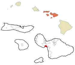 Location in Maui County and the state of Hawaii | |
| Coordinates: 20°48′34″N 156°29′27″W | |
| Country | United States |
| State | Hawaii |
| County | Maui |
| Area | |
| • Total | 7.49 sq mi (19.39 km2) |
| • Land | 5.16 sq mi (13.35 km2) |
| • Water | 2.33 sq mi (6.04 km2) |
| Elevation | 98 ft (30 m) |
| Population (2020) | |
| • Total | 310 |
| • Density | 60.14/sq mi (23.22/km2) |
| Time zone | UTC-10 (Hawaii-Aleutian) |
| Area code | 808 |
| FIPS code | 15-46400 |
| GNIS feature ID | 0361945 |
Geography
Maalaea is located at 20°48′34″N 156°29′27″W (20.809336, -156.490729).[2]
According to the United States Census Bureau, the CDP has a total area of 7.8 square miles (20.1 km2), of which 5.4 square miles (14.1 km2) is land and 2.3 square miles (6.0 km2), or 29.99%, is water.[3]
Historical Airport
Maalaea is the original site for the Maui Airport, a small, turf runway airport situated near the Oceanside. Inter-Island Airways (Hawaiian Airlines) built the airport after being granted permission after a three-year-long fight to secure an airport on Maui. The fight was justified as Inter-Island had already recognized that Maui was going to be the second-largest air traffic hub besides Honolulu, and still is today. Though, many needles were located on the field area from trees that would surely pop airplane tires, by the time of service inauguration, these had been picked clean as exclaimed by many Inter-Island staff. This field served fine, however, due to the field's location, it would constantly flood, even after the flood ended the field would be wet for days, and Inter-Island would end up using Kahului Harbor for a landing strip for its amphibian aircraft, the S-38, and S-43. The airport eventually closed and was replaced by a site at Puunene.[4]
Demographics
| Census | Pop. | Note | %± |
|---|---|---|---|
| 2010 | 352 | — | |
| 2020 | 310 | −11.9% | |
| U.S. Decennial Census[5] | |||
2010 census
As of the census of 2010, there were 352 people, 196 households, and 81 families residing in the CDP. The population density is 45 people per square mile (17 people/km2). The racial makeup of the CDP was 78.1% White, 2% African American, 0.3% Native American, 9.7% Asian, 5.4% Pacific Islander, 1.1% from other races, and 3.4% from two or more races. Hispanic or Latino of any race were 3.7% of the population.[6]
There were 196 households, out of which 3.6% had children under the age of 18 living with them, 37.2% were married couples living together, 2.6% had a female householder with no husband present, and 58.7% were non-families. 51% of all households were single individuals and 42.3% had someone living alone who was 65 years of age or older. The average household size was 1.56 and the average family size was 2.15.[6]
In the CDP the population was spread out, with 4.5% under the age of 18, 2.8% from 18 to 24, 15.3% from 25 to 44, 44.6% from 45 to 64, and 22.9% who were 65 years of age or older. The median age was 59 years. For every 100 females, there were 114 males. For every 100 females age 18 and over, there were 135 males.[6]
The median income for a household in the CDP was $73,083, and the median income for a family was $101,250. Males had a median income of $53,750 versus $72,708 for females. The per capita income for the CDP was $53,152. About 2.3% of families and 9.7% of the population were below the poverty line, including 16.7% of those under age 18 and 7.2% of those age 65 or over. [6]
2020 census
There were 310 people, 561 housing units, and 148 housing units in the CDP. There were 220 White people, 5 African Americans, 0 Native Americans, 27 Asians, 16 Pacific Islanders, 5 people from some other race, and 37 people from two or more races. There were 24 people of Hispanic or Latino origin.[7]
The ancestry was 18.8% English, 17% German, 9.4% Irish, 5.4% French, 3.6% Polish, 3.1% Italian, 3.1% Scottish, and 1.8% Norwegian.[7]
The median age was 63 years old. 43.5% of the population were 65 or older, with 28.7% between the ages of 65 to 74, 13.5% between the ages of 75 to 84, and 1.3% 85 or older. 12.1% of the population were veterans.[7]
The median household income was $91,250, with families having $138,125, married couples having $140,625, and non-families having $61,563. 6.3% of the population were in poverty.[7]
Surfing
The wave called the "Maalaea freight train", is a right-hander off the breakwall and over a shallow coral reef. It is considered to be one of the world's fastest rideable waves, but is rideable only on large southerly swells.[8]
Gallery
 Maalaea Ebisu Kotohira Jinsha in Maalaea. Photograph by Alan Gowans. Department of Image Collections, National Gallery of Art Library.
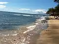 Maalaea "Coral Gardens" beach, looking north
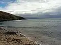 Maalaea "Coral Gardens" beach, looking south
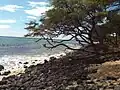 Maalaea "Coral Gardens" near Pali tunnel
Notes
- "2020 U.S. Gazetteer Files". United States Census Bureau. Retrieved December 18, 2021.
- "US Gazetteer files: 2010, 2000, and 1990". United States Census Bureau. 2011-02-12. Retrieved 2011-04-23.
- "Geographic Identifiers: 2010 Demographic Profile Data (DP-1): Maalaea CDP, Hawaii". United States Census Bureau. Retrieved December 29, 2011.
- "Maalaea Airport". aviation.hawaii.gov. Retrieved 2023-01-10.
- "Census of Population and Housing". Census.gov. Retrieved June 4, 2016.
- Bureau, U.S. Census. "U.S. Census website". United States Census Bureau. Retrieved 2018-05-21.
- "Explore Census Data". data.census.gov. Retrieved 2023-05-31.
- "Maalaea Freight Trains Maui Surfing". World News. Retrieved 2018-05-21.
References
- Clark, John R. K. (1989), The Beaches of Maui County, University of Hawaii Press, pp. 50–51, ISBN 0-8248-1246-8
External links
 Media related to Maalaea, Hawaii at Wikimedia Commons
- Maalaea Community Association web site.
State of Hawaii | |
|---|---|
Honolulu (capital) | |
| Topics | |
| Society | |
| Main islands | |
| Northwestern Islands | |
| Communities | |
| Counties | |
| Sovereignty Movement | |
Islands, municipalities, and communities of Maui County, Hawaii, United States | ||
|---|---|---|
| CDPs |  Map of Hawaii highlighting Maui County | |
| Other communities | ||
| Footnotes | ‡This populated place also has portions in an adjacent county or counties | |