Macaracas District
Macaracas District is a district (distrito) of Los Santos Province in Panama. The population according to the 2000 census was 9,137.[2] The district covers a total area of 504 km². The capital lies at the city of Macaracas.[2]
Macaracas District | |
|---|---|
 Coat of arms | |
 | |
 Macaracas District Location of the district capital in Panama | |
| Coordinates: 7°43′48″N 80°32′24″W | |
| Country | |
| Province | Los Santos Province |
| Capital | Macaracas |
| Area | |
| • Total | 195 sq mi (504 km2) |
| Population (2020)[1] | |
| • Total | 9,285 |
| • Density | 48/sq mi (18.4/km2) |
| Time zone | UTC-5 (ETZ) |

A Macaracas style Coclé bowl, from around 800-1000 AD. The background design is stingray spines.
The Macaracas style of Gran Coclé Precolumbian pottery was named for archaeological sites found in this District.
Administrative divisions
Macaracas District is divided administratively into the following corregimientos:

References
- "Macaracas (District, Panama) - Population Statistics, Charts, Map and Location". citypopulation.de. Retrieved 2023-10-05.
- "Districts of Panama". Statoids. Retrieved April 12, 2009.
Capital: Las Tablas | ||
| Guararé District | 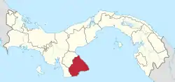 | |
| Las Tablas District | ||
| Los Santos District | ||
| Macaracas District | ||
| Pedasí District | ||
| Pocrí District | ||
| Tonosí District | ||
| Bocas del Toro Province | |
|---|---|
| Chiriquí Province | |
| Coclé Province | |
| Colón Province | |
| Darién Province | |
| Herrera Province | |
| Los Santos Province | |
| Panamá Province | |
| Veraguas Province | |
| West Panamá Province | |
This article is issued from Wikipedia. The text is licensed under Creative Commons - Attribution - Sharealike. Additional terms may apply for the media files.