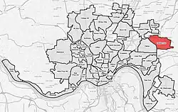
Madisonville, Cincinnati
Madisonville is a neighborhood in Cincinnati, Ohio. The population was 9,141 at the 2010 census.[1]
Madisonville | |
|---|---|
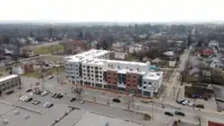 Aerial View of Madisonville in 2020 | |
 Flag | |
 | |
| Country | United States |
| State | Ohio |
| City | Cincinnati |
| Population (2020) | |
| • Total | 10,244 |
| Time zone | UTC-5 (EST) |
| • Summer (DST) | UTC-4 (EDT) |
| ZIP code | 45214 |
History
Madisonville was established in 1809[2] and originally named Madison after the newly elected James Madison, the fourth president of the United States.[3] Prior to 1809, European-American settlers began to arrive in the territory, mostly from the mid-Atlantic and New England states. In 1826, the post office was named Madisonville, in order to avoid confusion with other towns.[4]
The first permanent settler was Joseph Ward, a sixty-five-year-old American Revolutionary War veteran from New Jersey. Joseph and his two sons, Usual and Israel, came overland by horseback intending to settle in the new outpost of Columbia. Joseph's wife, Phebia, and other sons and daughters traveled by flatboat down the Ohio River to reunite at Columbia.
Seeing the flooding at that location, they decided to go up higher and settled in what was to become Madisonville. Joseph and his sons built the first house, a log cabin, in 1797 along a well-known Native American trail near what is now Whetsel and Monning Avenue.
In 1830, the population of the village was 284.[5] In 1900, the population of Madisonville was reported to be 3,140.[6] Madisonville was annexed by the City of Cincinnati in 1911.[7]
Demographics
| Year | Pop. | ±% |
|---|---|---|
| 1900 | 2,930 | — |
| 1910 | 5,093 | +73.8% |
| 1920 | 8,025 | +57.6% |
| 1930 | 9,789 | +22.0% |
| 1940 | 11,294 | +15.4% |
| 1950 | 12,807 | +13.4% |
| 1960 | 17,447 | +36.2% |
| 1970 | 17,897 | +2.6% |
| 1980 | 13,157 | −26.5% |
| 1990 | 12,216 | −7.2% |
| 2000 | 10,827 | −11.4% |
| 2010 | 9,141 | −15.6% |
| 2020 | 9,768 | +6.9% |
According to the 2010 US Census, 39.2% of the neighborhood's population is White alone and 58.7% is Black or African American alone.
References
- "Madisonville Statistical neighborhood approximation". City of Cincinnati. p. 2. Retrieved 27 January 2018.
- Kenny, Daniel (1875). "Illustrated Cincinnati". Stevens. p. 17. Retrieved 2013-05-19.
- "Madisonville", Website, Accessed on 02-02-10.
- Clarke, S. J. (1912). "Cincinnati, the Queen City, 1788-1912, Volume 2". The S. J. Clarke Publishing Company. p. 531. Retrieved 2013-05-20.
- Kilbourn, John (1833). The Ohio Gazetteer, or, a Topographical Dictionary. Scott and Wright. pp. 289. Retrieved 12 December 2013.
- Industrial Bureau of Cincinnati (1909). "The Cincinnati Industrial Magazine, Volumes 1-2". p. 238. Retrieved 2013-05-20.
- Clarke, S. J. (1912). "Cincinnati, the Queen City, 1788-1912, Volume 2". The S. J. Clarke Publishing Company. p. 528. Retrieved 2013-05-20.