Mai'Adua
Mai'Adua city (or Birnin Maiaduwa) is a city in Katsina state and a Local Government Area in Katsina State, Nigeria, sharing a border with the Republic of Niger. Its headquarters is in the city of Mai'Adua on the A2 highway.
Mai'Adua city
danburan kano ta arewa city maiadua city | |
|---|---|
LGA and town | |
| Nickname: maiadua city | |
| Motto: danduran kano ta arewa | |
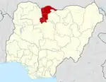
 Mai'Adua city Location in Nigeria | |
| Coordinates: 13°11′26″N 8°12′42″E | |
| Country | |
| State | Katsina State |
| established | 1990 |
| Government | |
| • Chairman | mamman na allahu |
| Area | |
| • Total | 528 km2 (204 sq mi) |
| Population (2006 census) | |
| • Total | 201,178 |
| Time zone | UTC+1 (WAT) |
| 3-digit postal code prefix | 824 |
| ISO 3166 code | NG.KT.MDW |
It has an area of 528 km2 and a population of 201,178 at the 2006 census.
The postal code of the area is 824.[1]
It has a very large historical urban and rural market operating on Sundays. The market is international serving as exchange point between Nigeria and Niger Republic. Livestock, including cattle, sheep, goats, camels, donkeys, and horses are the main commodities mainly from Niger, while grains such as maize, sorghum, millet, and soybean mainly come from Nigeria.
Districts and Villages
Koza
Mai-Koni
Natsalle
Mai-Adua
Saitawa
Makerawa
Kwadage
Galadimawa
Baida
Buduma
Bula
Daba
Dadin Sarki
Dagon Hawa
Dagura
Dan Nasara
Dan Yawa
Danmisa
Dansawa
Dunyashe
Garon Maje
Gojo-Gogo
Guzu
Gwajo-Gwajo
Jassai
Jirdede
Ka Dangwaras
Kahe
Kalansanmi
Katsinawa
Kokutuko
Kongolam
Kudi Jika
Kurchi
Madaddaga
Mai Daniya
Mai Faru
Mai Gari
Mai Kwamame
Maikoni
Maiturmi
Muludu
Shabewa
Sharta
Shekiya
Shiroka
Tadi
Tafakai
Tilla
Tsabu
Tsauri
Tsiga-Hamisu
Tsohou Birni
Tuga
Unguwar Jimmai
Unguwar Tuka
Wala
Yan Kara
Yarima Jatau
Yarogel
Yar Yandi
Yan Harkum[2]
Climatic Condition
With an average annual temperature of 37°C, 653 mm of rainfall, 263 dry days, and a 30% average humidity, Mai'Adua has a semi-arid climate. [3][4][5]
Geography
Mai Adua Local Government Area covers a complete expanse of 528 square kilometers and maintains an average temperature of 33 degrees Celsius. This LGA is situated in the Sahel Savannah region and is primarily known for its sandy landscapes. The terrain of Mai Adua LGA is marked by numerous rocks and hills scattered throughout the area.[6]
Economy
Mai Adua Local Government Area enjoys a thriving trade industry and is home to several markets, notably the bustling Mai Adua central market, which draws a large number of buyers and sellers. Agriculture is a cornerstone of the economy in Mai Adua, with the cultivation of crops like millet, corn, groundnut, and beans being prevalent. Additionally, the people of Mai Adua Local Government Area are involved in vital economic pursuits such as craftsmanship and hunting.[7]
References
- "Post Offices- with map of LGA". NIPOST. Archived from the original on 2012-11-26. Retrieved 2009-10-20.
- "Mai-Adua LGA". www.finelib.com. Retrieved 2023-10-26.
- "Mai'Adua weather and climate ☀️ Best time to visit 🌡️ Temperature". www.besttimetovisit.co.nz. Retrieved 2023-08-29.
- "Mai'Adua Climate, Weather By Month, Average Temperature (Nigeria) - Weather Spark". weatherspark.com. Retrieved 2023-08-29.
- "Mai'Adua, Katsina, Nigeria - City, Town and Village of the world". en.db-city.com. Retrieved 2023-08-29.
- "Mai'adua Local Government Area". www.manpower.com.ng. Retrieved 2023-10-26.
- "Mai'adua Local Government Area". www.manpower.com.ng. Retrieved 2023-10-26.
State capital: Katsina | ||
| Topics |
|  |
| LGAs | ||