Mairang
Mairang is the headquarters of Eastern West Khasi Hills district of Meghalaya, India. It is located at about 40 km from the state capital Shillong, and 45 km (approx.) from Nongstoin along National Highway 106.
Mairang | |
|---|---|
city | |
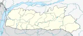 Mairang Location in Meghalaya, India  Mairang Mairang (India) | |
| Coordinates: 25.57°N 91.63°E | |
| Country | |
| State | Meghalaya |
| District | Eastern West Khasi Hills |
| Elevation | 1,564 m (5,131 ft) |
| Population (2001) | |
| • Total | 11,517 |
| Languages | |
| • Official | Maram, Khasi and English |
| Time zone | UTC+5:30 (IST) |
| Vehicle registration | ML |
| Climate | Cwb |
Geography
Mairang is located at 25.57°N 91.63°E.[1] It has an average elevation of 1564 metres (5131 feet).
Demographics
As of 2001 India census,[2] Mairang had a population of 11,517. Males constitute 50% of the population and females 50%. Mairang has an average literacy rate of 62%, higher than the national average of 59.5%: male literacy is 62%, and female literacy is 63%. In Mairang, 22% of the population is under 6 years of age.
Education
Khadsawphra College & Higher Secondary, Mairang Presbyterian Science College, and Tirot Sing Memorial College are three institutions of higher education in Mairang.
See also
References
- Falling Rain Genomics, Inc - Mairang
- "Census of India 2001: Data from the 2001 Census, including cities, villages and towns (Provisional)". Census Commission of India. Archived from the original on 16 June 2004. Retrieved 1 November 2008.
| State symbols | |
|---|---|
| Topics | |
| Administration | |
| Divisions |
|
| Districts | |
| Municipalities | |