Makrychori
Makrychori (Greek: Μακρυχώρι, Katharevousa: Μακρυχώριον) is a former municipality in the Larissa regional unit, Thessaly, Greece. Since the 2011 local government reform it has been part of the municipality Tempi, of which it is a municipal unit.[2] Population 2,553 (2011). The municipal unit has an area of 107.767 km2.[3] The municipality was created under the Kapodistrias Law in 1997 out of the former communes of Elateia, Evangelismos, Gyrtoni and Parapotamos.
Makrychori
Μακρυχώρι | |
|---|---|
 Makrychori Location within the regional unit 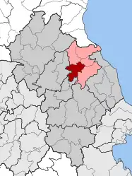 | |
| Coordinates: 39°48′N 22°29′E | |
| Country | Greece |
| Administrative region | Thessaly |
| Regional unit | Larissa |
| Municipality | Tempi |
| Districts | 4 |
| • Municipal unit | 107.767 km2 (41.609 sq mi) |
| Elevation | 108 m (354 ft) |
| Population (2011)[1] | |
| • Municipal unit | 2,553 |
| • Municipal unit density | 24/km2 (61/sq mi) |
| Community | |
| • Population | 1,689 (2011) |
| Time zone | UTC+2 (EET) |
| • Summer (DST) | UTC+3 (EEST) |
| Postal code | 40 009 |
| Vehicle registration | ΡΙ (Rho Iota) |
Subdivisions
The municipal unit Makrychori is subdivided into the following communities (constituent villages in brackets):
- Elateia
- Evangelismos
- Makrychori (Makrychori, Gyrtoni)
- Parapotamos
Population
| Year | Municipal unit population | Community population | Village population |
|---|---|---|---|
| 1991 | - | - | 1,941 |
| 1991 | 3,004 | - | 1,666 |
| 2001 | 2,976 | 1,863 | 1,787 |
| 2011 | 2,553 | 1,689 | 1,615 |
Geography
Makrychori is located next to the Thessalian Plain, situated between the river Pineios and the GR-1/E75 (Athens - Larissa - Thessaloniki). The mountains can be seen to the west and east, the southern portions of the municipality are farmlands.
References
- "Απογραφή Πληθυσμού - Κατοικιών 2011. ΜΟΝΙΜΟΣ Πληθυσμός" (in Greek). Hellenic Statistical Authority.
- "ΦΕΚ B 1292/2010, Kallikratis reform municipalities" (in Greek). Government Gazette.
- "Population & housing census 2001 (incl. area and average elevation)" (PDF) (in Greek). National Statistical Service of Greece. Archived from the original (PDF) on 2015-09-21.