British Columbia Highway 1
Highway 1 is a provincial highway in British Columbia, Canada, that carries the main route of the Trans-Canada Highway (TCH). The highway is 1,047 kilometres (651 mi) long and connects Vancouver Island, the Greater Vancouver region in the Lower Mainland, and the Interior. It is the westernmost portion of the main TCH to be numbered "Highway 1", which continues through Western Canada and extends to the Manitoba–Ontario boundary. The section of Highway 1 in the Lower Mainland is the second-busiest freeway in Canada, after Ontario Highway 401 in Toronto.
Highway 1 | ||||
|---|---|---|---|---|
| Trans-Canada Highway | ||||
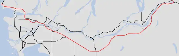
A map of southern British Columbia with Hwy 1 highlighted in red | ||||
| Route information | ||||
| Maintained by British Columbia Ministry of Transportation and Infrastructure | ||||
| Length | 1,047 km (651 mi) | |||
| Existed | 1941–present | |||
| Vancouver Island section | ||||
| Length | 116 km (72 mi) | |||
| South end | Dallas Road in Victoria | |||
| Major intersections | ||||
| North end | ||||
| Mainland section | ||||
| Length | 877 km (545 mi) | |||
| West end | ||||
| Major intersections |
| |||
| East end | Alberta border at Kicking Horse Pass continues as | |||
| Location | ||||
| Country | Canada | |||
| Province | British Columbia | |||
| Highway system | ||||
|
| ||||
| ||||
.svg.png.webp)
The highway's western terminus is in the provincial capital of Victoria, where it serves as a city street and freeway in the suburbs. Highway 1 travels north to Nanaimo and reaches the Lower Mainland at Horseshoe Bay via a BC Ferries route across the Strait of Georgia. The highway bypasses Vancouver on a freeway that travels through Burnaby, northern Surrey, and Abbotsford while following the Fraser River inland. The freeway ends in Hope, where Highway 1 turns north and later east to follow the Fraser and Thompson rivers into the Interior and through Kamloops. The highway continues east across the Columbia Mountains, serving three national parks: Mount Revelstoke, Glacier, and Yoho. Highway 1 enters Alberta at Kicking Horse Pass near Banff National Park.
Highway 1 was preceded by several overland trails and wagon roads established in the mid-to-late 19th century, including the Old Yale Road in the Fraser Valley, the Cariboo Road, and the Big Bend Highway. The provincial government designated Highway 1 in 1941 on a portion of the Island Highway between Victoria and Kelsey Bay as well as the Vancouver–Banff highway. It was incorporated into the national Trans-Canada Highway program, which was established in 1949 and completed in 1962. Other sections of the highway were realigned in later years, including a new freeway in the Lower Mainland that opened in the 1960s and 1970s and was numbered Highway 401.
Vancouver Island section
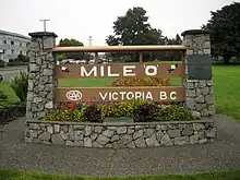
The western terminus of Highway 1 and the 7,821-kilometre (4,860 mi) main route of the Trans-Canada Highway is at Dallas Road on the southern coast of Victoria, which faces the Strait of Juan de Fuca.[1] The terminus is marked by the Mile Zero Monument, a wooden sign at the foot of Beacon Hill Park, with a nearby statue of runner Terry Fox to commemorate his cross-country marathon that was planned to end at the monument.[2][3] The highway travels north on Douglas Street and forms the boundary between the residential James Bay neighbourhood to the west and Beacon Hill Park to the east. At the northwest edge of the park, Blanshard Street from the street to run a block east, staying parallel to Douglas Street.[4] Highway 1 passes the Royal BC Museum and intersects Belleville Street, a short connector that carries a section of Highway 17 from the Black Ball Ferries terminal (which is used by the MV Coho to Port Angeles, Washington) and passes the British Columbia Parliament Buildings.[1][5]
The highway travels through Downtown Victoria and passes several city landmarks, including the Fairmont Empress Hotel, the Bay Centre, Chinatown, and Save-On-Foods Memorial Centre.[6] It follows Douglas Street, a six-lane urban thoroughfare with bus lanes during peak periods, and continues north into the suburban municipality of Saanich.[7][8] Near the Uptown shopping centre, Highway 1 turns west and becomes a limited-access road that travels alongside the Galloping Goose Regional Trail through residential areas and along the north side of Portage Inlet. The highway becomes a full freeway with four-to-six lanes as it enters the town of View Royal and travels around the north side of Mill Hill Regional Park. It then intersects Highway 14 in Langford and reverts to a limited-access road with a median divider.[9][10] Highway 1 (part of the Island Highway) then travels around Bear Mountain and turns north to follow the Goldstream River into Goldstream Provincial Park, where it meets several trailheads.[4][11]
The Island Highway continues along the west side of the Saanich Inlet and enters the Cowichan Valley Regional District near Malahat. It descends from Malahat Summit, located at 352 metres (1,155 ft) above sea level, on a highway with passing lanes and a median barrier added in the late 2010s in response to a high rate of collisions.[12] The section also has occasional closures with no road detour, relying on the limited-capacity Mill Bay Ferry as the sole remaining connection between Greater Victoria and other Vancouver Island communities.[13] Highway 1 passes the Malahat SkyWalk, an observation built by the Malahat First Nation,[14] and through farmland surrounding Mill Bay. The highway travels around central Duncan and through Ladysmith as it continues north as a divided highway with limited access at signalized intersections.[4] In southern Nanaimo, it has a short concurrency with Highway 19, which continues east to the Duke Point ferry terminal and northwest along the Strait of Georgia. Highway 1 travels through central Nanaimo on Nicol Street and Stewart Avenue to the Departure Bay ferry terminal, where the Vancouver Island section ends.[1] BC Ferries operates an automobile ferry service from Departure Bay to Horseshoe Bay that carries Highway 1 to the Lower Mainland region of British Columbia. A typical vessel assigned to the route can carry 1,460 to 1,571 passengers and 310 to 322 vehicles.[15]
History
The Vancouver Island section of Highway 1 was designated in the initial numbering scheme announced by the provincial government in March 1940, along with Highway 1A.[16] It originally connected Victoria to Kelsey Bay, a small coastal community north of Campbell River. The Vancouver Island section was truncated to downtown Nanaimo in 1953, with the section north of Nanaimo being re-numbered to Highway 19. When BC Ferries took over the ferry route between Departure Bay in Nanaimo and Horseshoe Bay in West Vancouver in 1961, Highway 1 was extended to the Departure Bay ferry dock.
The Malahat Highway was completed in 1911 as a gravel road with a single lane and was later upgraded to two paved lanes.[17] A bridge across the Finlayson Arm to bypass the section was among 19 options studied in 2007, but were discarded in favor of other solutions that would cost less.[18][19] In 2019, the provincial government studied the construction of a permanent detour for the Goldstream–Malahat section of Highway 1 and identified several potential routes, but instead decided to move forward with safety improvements to the existing highway.[20] The section was severely damaged by several floods in November 2021, which closed the road for several days and required $15 million in repairs the following year.[21]
Lower Mainland section
Route details
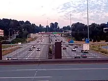
Sections of Highway 1 from Grandview Highway in Vancouver to 216 Street in Langley vary from being 3 to 4 lanes in each direction, with one of these lanes being a high-occupancy vehicle (HOV) lane. These HOV lanes were constructed in 1998 as part of the BC MOT's "Go Green" project to promote the use of HOV vehicles, and cost $62 million.[22] The highway shortens to two lanes per direction after leaving Langley (Metro Vancouver), and enters Abbotsford (Fraser Valley).
North Shore
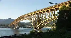
The Upper Levels Highway opened between Horseshoe Bay and Taylor Way in West Vancouver on September 14, 1957, replacing a section of Marine Drive that had carried Highway 1.[23][24] Construction on a new, high-level Second Narrows Bridge began two months later and was planned to be incorporated into the Trans-Canada Highway upon completion.[25][26] On June 17, 1958, several spans of the unfinished bridge collapsed during work on the main arch; 18 workers died and one diver also died during a later search at the site.[27] The Second Narrows Bridge was dedicated to the accident's victims and opened to traffic on August 25, 1960; it cost $23 million to construct and was the second-longest bridge in Canada at the time of its completion.[28] The Upper Levels Highway was extended 9.3 kilometres (5.76 mi) east to the Second Narrows Bridge on March 4, 1961; the limited-access highway across North Vancouver cost $50 million to construct.[29][30]
Vancouver to Chilliwack
Prior to the opening of the freeway (and prior to the 1980s and 1990s, expressway) segments of the present Trans-Canada, traffic used the Pattullo Bridge, Kingsway, and Fraser Highway as the Trans-Canada Highway. These roads were a part of the Highway 1 from its designation in 1940[31][32] until the redesignation of the B.C.'s 400 series highways in 1972/73.[33][34]
By 1932 a new cutoff across northern parts of the drained Sumas Lake was mostly built.[35][36] The cutoff bypassed the Yale Road which avoided the historical lake by running on its southern flank and along the base of Vedder Mountain. The highway was initially partly gravel,[37] but it was fully paved within a few years of its opening.[38]
From 1960 to 1964, the province opened several expressway and freeway segments as a part of a continuous express route between Bridal Falls and Taylor Way in West Vancouver.
On August 1, 1960, the Chilliwack Bypass was officially opened by Highways Minister Phil Gaglardi, MLA for Chillwack William Kenneth Kiernan and a six-year-old girl who cut the blue ribbon.[39] About 6.4 km (4 mi) of the road had been opened before Gaglardi officially opened the bypass.[40] Work on the bypass started on December 12, 1956, with two men clearing bushes.[41]
Around the time of opening of the Chilliwack Bypass, a bypass of Abbotsford was also being constructed.[42] That section of freeway was officially opened by Phil Gaglardi on April 19, 1962.[43][44]
On May 1, 1964, the section of Freeway between what is now north of the 1st Avenue interchange to the Cape Horn Interchange opened.[45][46] This was followed on June 12 by the opening of the Port Mann bridge, and the official opening of the freeway-expressway system from Bridal Falls to Taylor Way. A 90-year-old man and 11-year-old girl assisted Premier W.A.C. Bennett and Phil Gaglardi in opening the bridge.[47][48] At the time of the bridge's opening, various speed limits were in effect. The section from Bridal Falls to the Port Mann Bridge had a 70 mph (110 km/h) limit. Through Burnaby 65 mph (105 km/h) was the limit. Speeds dropped on approach to Cassiar Street with a 50 mph (80 km/h) limit west of Boundary Road, with a drop to 30 mph (48 km/h) for Cassiar Street.[48]
New interchanges and upgrades
Over the years, various interchanges have been built and rebuilt.
On July 31, 1969, the interchange with Lickman Road in Chilliwack opened.[49] The Prest Road overpass followed in the early 1970s.[50]
In January 1992 the Cassiar Tunnel opened. The project replaced a surface street section of Cassiar Street which was used by traffic to get from the Burnaby Freeway to the Ironworkers Memorial Bridge.[51]
Through the 2000s and 2010s multiple interchanges were upgraded and rebuilt along the highway. The Gateway program saw the rebuilding of several interchanges from Willingdon Avenue to 176 Street. Through Abbotsford the Mount Lehman/Fraser Highway, Clearbrook Road, and McCallum Road interchanges were rebuilt.[52][53][54]
On June 9, 2011, Highway 1 between 152 Street in Surrey and Highway 11 in Abbotsford was designated as the Highway of Heroes.[55]
On September 4, 2020, a new interchange with 216 Street was opened.[56]
On November 10, 2022, it was announced that major construction of a new overpass at Glover Road (which will be built first), a revised interchange with Highway 10/232 St. and widening to three lanes between 216 Street and Highway 13/264 St. had started.[57] This work is part of a plan to eventually widen the highway to Whatcom Road in Abbotsford.[58]
Interior section
Several sections of Highway 1 between Revelstoke and the Alberta border are under the jurisdiction of Parks Canada.[59]
History
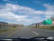
Since the 2000s, 25 kilometres of road in the Kicking Horse Pass near Golden have been rebuilt in phases to modern standards, with 4 lanes and the removal of sharp corners.[60][61][62] The final phase is due for completion in 2024.[61]
During major floods in November 2021, sections of Highway 1 between Hope and Spences Bridge were washed away into the Thompson River. Other sections of the highway on Vancouver Island and a railroad underpass near Lytton were also damaged in the same event. As a result of the floods, which also damaged other highways in the Fraser Valley, road connections from Metro Vancouver to the rest of Canada were cut off.[63]
Future
The Interior section of Highway 1 is considered sub-standard when compared to other highways with similar traffic volume in the U.S. or other parts of Canada. The majority of the route is a dangerous, undivided two-lane highway with sharp corners, prone to frequent closures and accidents.[64] To address this, the Ministry of Transportation and Infrastructure has undertaken an effort to twin the highway to four-lane 100 km/h standards between Kamloops and Alberta, with a targeted completion date of 2050. Several stretches of four-lane divided highway, including the Monte Creek to Pritchard section; the four-lane portions of the Kicking Horse Canyon, the 13 km-long passing lanes near Blind Bay, and many smaller four-lane divided fragments typically 2–4 km in length, are the results of this effort. As of 2020, about 25 percent of the highway between Alberta and Kamloops has been upgraded to a divided four-lane cross-section. Several new projects have been funded and are expected to the constructed by 2023, including:[59]
- A new 4.9 km-long four-lane divided section around Chase, involving the construction of an interchange at the town;
- A new interchange and twinned highway at the West entrance of Salmon Arm;
- A new four-lane bridge across the Shuswap River in Sicamous;
- A new rest area and a 2 km-long four-lane section in the Illecillewaet Valley;
- A 4.4 km-long twinning near Quartz Creek east of Golden;
- And upgrading the remaining 4 km-long stretch of two-lane highway in the Kicking Horse Canyon.
Major intersections
| Regional District | Location | km[65] | mi | Exit | Destinations | Notes |
|---|---|---|---|---|---|---|
| Capital | Victoria | 0.00 | 0.00 | Dallas Road | Western terminus and mile zero of Trans-Canada Highway; south end of Douglas Street | |
| 1.20 | 0.75 | Northbound right-in/right-out; BC Ferries to Vancouver (Tsawwassen) and Gulf Islands | ||||
| 1.30 | 0.81 | Black Ball Ferries to Port Angeles; Victoria Clipper passenger ferry to Seattle | ||||
| 2.10 | 1.30 | Johnson Street | One-way pair; access to Johnson Street Bridge | |||
| 2.20 | 1.37 | Pandora Avenue | ||||
| 3.10 | 1.93 | Bay Street | ||||
| 3.40 | 2.11 | Gorge Road, Hillside Avenue, Government Street | Former Hwy 1A north | |||
| Victoria–Saanich line | 4.50 | 2.80 | Tolmie Avenue; north end of City of Victoria jurisdiction | |||
| Saanich | 5.10 | 3.17 | Saanich Road, Boleskine Road | North end of Douglas Street | ||
| 6.44 | 4.00 | Tillicum Road | At-grade intersection, signalized; south end of freeway | |||
| 6.79 | 4.22 | Burnside Road, Interurban Road | Southbound exit only | |||
| 7.52 | 4.67 | 6 | McKenzie Avenue Interchange [66] | |||
| View Royal | 9.59 | 5.96 | 8 | Helmcken Road | Helmcken Road Interchange | |
| 11.30 | 7.02 | 10 | Colwood (Island Highway, Burnside Road) | Colwood Interchange Northbound exit and southbound entrance; former Hwy 1A south | ||
| 12.24 | 7.61 | 11 | Colwood (Six Mile Road) | Thetis Interchange Southbound exit and northbound entrance | ||
| Langford | 15.29 | 9.50 | 14 | Millstream Road Interchange | ||
| 15.94 | 9.90 | 15 | McCallum Road | Northbound exit only | ||
| 16.77 | 10.42 | 16 | Leigh Road/Bear Mountain Parkway | Bear Mountain Interchange | ||
| 18.29 | 11.36 | Westshore Parkway | At-grade, signalized; north end of freeway | |||
| Cowichan Valley | | 37.88 | 23.54 | Bamberton Interchange | ||
| 40.95 | 25.45 | Butterfield Road | ||||
| Mill Bay | 42.68 | 26.52 | Frayne Road | |||
| 43.93 | 27.30 | |||||
| 44.47 | 27.63 | Shawnigan / Mill Bay Road – Shawnigan Lake | ||||
| | 45.31 | 28.15 | Cobble Hill Road, Kilmalu Road | |||
| 48.17 | 29.93 | Hutchinson Road – Cobble Hill, Arbutus Ridge | ||||
| 49.55 | 30.79 | Fisher Road | ||||
| 51.36 | 31.91 | Cobble Hill Road, Cowichan Bay Road – Cobble Hill, Cowichan Bay | ||||
| 55.24 | 34.32 | Koksilah Road | ||||
| 57.31 | 35.61 | Bench Road | ||||
| 59.19 | 36.78 | Wilson Road, Cowichan Bay Road – Cowichan Bay | no left turns onto highway. no left turn onto Wilson | |||
| Cowichan First Nation (Koksilah) | 61.01 | 37.91 | Allenby Road, Chaster Road | |||
| 61.56 | 38.25 | Boys Road | ||||
| Duncan | 62.35 | 38.74 | Trunk Road – City Centre, Maple Bay | |||
| 62.56 | 38.87 | Coronation Street | ||||
| North Cowichan | 62.95 | 39.12 | James Street | |||
| 63.66 | 39.56 | Beverley Street | ||||
| 65.74 | 40.85 | Drinkwater Road | ||||
| 67.24 | 41.78 | |||||
| 69.41 | 43.13 | Mays Road | ||||
| 74.04 | 46.01 | Hwy 1A is unsigned | ||||
| 78.42 | 48.73 | |||||
| Ladysmith | 84.85 | 52.72 | Thicke Road, Edgelow Road | |||
| 88.19 | 54.80 | Chemainus Road, Davis Road (Hwy 1A south) | Hwy 1A is unsigned | |||
| 90.23 | 56.07 | Roberts Street, Transfer Beach Boulevard | ||||
| 91.16 | 56.64 | First Avenue | ||||
| Stz'uminus First Nation | 94.13 | 58.49 | Oyster Sto-Lo Road | |||
| | 96.54 | 59.99 | Cedar Road – Yellow Point, Cedar | |||
| Nanaimo | Cassidy | 98.02 | 60.91 | Timberlands Road | At-grade intersection, signalized | |
| 98.98 | 61.50 | |||||
| 101.38 | 62.99 | Nanaimo River Road, Fry Road | Nanaimo River Road Interchange | |||
| 103.52 | 64.32 | Morden Road | ||||
| Nanaimo | 105.75 | 65.71 | 7[lower-alpha 1] | Duke Point Interchange South end of Hwy 19 concurrency; BC Ferries to Vancouver (Tsawwassen) | ||
| 107.69 | 66.92 | 9[lower-alpha 2] | North end of Hwy 19 concurrency Partial-at grade intersection with northbound flyover to Hwy 19 north. | |||
| 108.13 | 67.19 | Cranberry Avenue | ||||
| 108.48 | 67.41 | 10th Street, Maki Road | ||||
| 112.35 | 69.81 | |||||
| 113.33 | 70.42 | Comox Road | ||||
| 113.61 | 70.59 | Stewart Avenue | Hwy 1 branches northeast. | |||
| 115.67 | 71.87 | |||||
| Strait of Georgia | ||||||
| Metro Vancouver | West Vancouver | 0.00 | 0.00 | Access via BC ferries; westbound access only | ||
| 0.35 | 0.22 | Keith Road | At-grade intersection, no westbound entrance; west end of freeway | |||
| 0.61 | 0.38 | 0 | Marine Drive | Horseshoe Bay Interchange Eastbound exit only | ||
| 1.84 | 1.14 | 2 | Eagleridge Drive to Marine Drive | Squamish Interchange Eastbound exit only; eastbound access to Hwy 99; westbound access via Hwy 99 | ||
| 2.21 | 1.37 | 3 | Eagle Ridge Interchange Westbound exit and eastbound entrance; west end of Hwy 99 concurrency; westbound Hwy 1 uses exit 3 | |||
| 4.29 | 2.67 | 4 | Woodgreen Drive, Headland Drive | |||
| 6.95 | 4.32 | 7 | Wentworth Avenue, Westmount Road | |||
| 8.54 | 5.31 | 8 | Cypress Bowl Road | To Cypress Mountain Ski Area | ||
| 9.94 | 6.18 | 10 | 22nd Street | Eastbound exit only | ||
| 10.59 | 6.58 | 10 | 21st Street, Westhill Drive | No eastbound exit | ||
| 11.46 | 7.12 | 11 | 15th Street | |||
| 13.15 | 8.17 | 13 | East end of Hwy 99 concurrency; former Hwy 1A east; to Lions Gate Bridge and Downtown Vancouver | |||
| North Vancouver (District) | 14.59 | 9.07 | 14 | Capilano Road | To Grouse Mountain | |
| 15.51 | 9.64 | 15 | Lloyd Avenue | Westbound right-in/right-out | ||
| North Vancouver (City) | 16.75 | 10.41 | 17 | Westview Drive | ||
| 17.92 | 11.13 | 18 | Lonsdale Avenue | |||
| North Vancouver (District) | 19.40 | 12.05 | 19 | Lynn Valley Road | ||
| 21.37 | 13.28 | 21 | Mountain Highway | Signed as exit 22A for Hwy 1 west exiting before Lynn Creek Bridge | ||
| 22.17 | 13.78 | 22 | Mount Seymour Parkway, Lillooet Road | |||
| 22.88 | 14.22 | 23 | Main Street, Dollarton Highway | Signed as exits 23A (Main Street) and 23B (Dollarton Highway) from Hwy 1 west | ||
| North Vancouver (District)–Vancouver line | 23.09– 24.42 | 14.35– 15.17 | Ironworkers Memorial Second Narrows Crossing over Burrard Inlet | |||
| Vancouver | 25.03 | 15.55 | 25 | McGill Street | ||
| 26 | Eastbound exit and westbound entrance; exits onto Cassiar Connector | |||||
| 25.39– 26.13 | 15.78– 16.24 | Cassiar Tunnel | ||||
| 26.32 | 16.35 | 26 | Westbound exit and eastbound entrance; exits onto Cassiar Connector; | |||
| 27.06 | 16.81 | 27 | 1st Avenue, Rupert Street | |||
| Vancouver–Burnaby line | 28.02 | 17.41 | 28 | Boundary Road | Eastbound to southbound exit; northbound to westbound entrance | |
| Burnaby | 28.44 | 17.67 | 28A | Grandview Highway | Westbound exit and eastbound entrance | |
| 28B | Grandview Highway | HOV-only interchange (left exit/entrance), westbound exit and eastbound entrance | ||||
| West end of HOV lanes | ||||||
| 29.64 | 18.42 | 29 | Willingdon Avenue | |||
| 32.26 | 20.05 | 32 | Sprott Street | Eastbound exit, westbound entrance | ||
| 33.11 | 20.57 | 33 | Kensington Avenue, Canada Way | No access from Hwy 1 east to Kensington Avenue north | ||
| 37.38 | 23.23 | 37 | Gaglardi Way | To Simon Fraser University | ||
| 39.11 | 24.30 | 38 | Government Street | Transit-only interchange (left exit/entrance); westbound exit and eastbound entrance | ||
| Coquitlam | 40.55 | 25.20 | 40 | Brunette Avenue | To New Westminster and Pattullo Bridge | |
| 43.68 | 27.14 | 44 | Cape Horn Interchange | |||
| Eastbound exit and westbound entrance; westbound exit via Hwy 7 east | ||||||
| Fraser River | 44.89– 46.91 | 27.89– 29.15 | Port Mann Bridge | |||
| Surrey | 48.26 | 29.99 | 48 | 152 Street – Surrey City Centre | Eastbound exit and westbound entrance; west end of Highway of Heroes | |
| 49.18 | 30.56 | 49 | 156 Street | HOV-only interchange (left exit) | ||
| 50.10 | 31.13 | 50 | 104 Avenue, 160 Street – Surrey City Centre | Former toll centre for Port Mann Bridge | ||
| 53.47 | 33.22 | 53 | BC Ferries to Victoria (Swartz Bay) and Nanaimo (Duke Point) | |||
| 56.79 | 35.29 | 57 | 192 Street north to unsigned Hwy 916 | Eastbound exit and westbound entrance; no access to/from 192 Street south of interchange; eastbound access to the Golden Ears Bridge | ||
| Langley (Township) | 58.62 | 36.42 | 58 | 200 Street – Langley City Centre to unsigned Hwy 916 | Westbound access to the Golden Ears Bridge | |
| 59.32 | 36.86 | 59 | 202 Street | HOV-only interchange (left exit)[67] | ||
| 62.12 | 38.60 | 61 | 216 Street | To Trinity Western University. Opened in September 2020.[67][68] | ||
| East end of HOV lanes | ||||||
| 65.73 | 40.84 | 66 | ||||
| 73.25 | 45.52 | 73 | ||||
| Fraser Valley | Abbotsford | 82.89 | 51.51 | 83 | ||
| 86.65 | 53.84 | 87 | Clearbrook Road | |||
| 90.21 | 56.05 | 90 | McCallum Road | |||
| 92.96 | 57.76 | 92 | Closest the Trans-Canada Highway gets to the US border in Western Canada; east end of Highway of Heroes | |||
| 95.51 | 59.35 | 95 | Whatcom Road | |||
| 98.98 | 61.50 | 99 | South Parallel Road | Eastbound only | ||
| 104.52 | 64.95 | 104 | No 3 Road – Yarrow, Cultus Lake | |||
| Chilliwack | 110.16 | 68.45 | 109 | Yale Road West | ||
| 116.05 | 72.11 | 116 | Lickman Road | |||
| 118.19 | 73.44 | 118 | Evans Road | Eastbound exit, westbound entrance | ||
| 119.36 | 74.17 | 119 | Vedder Road | Sardis Interchange; former Hwy 1A east | ||
| 120.53 | 74.89 | 120 | Young Road | Westbound exit, eastbound entrance | ||
| 122.79 | 76.30 | 123 | Prest Road | |||
| 129.21 | 80.29 | 129 | Annis Road | |||
| | 135.29 | 84.07 | 135 | |||
| 138.07 | 85.79 | 138 | Popkum Road – Popkum, Bridal Falls | |||
| 146.35 | 90.94 | 146 | Herrling Island | |||
| 151.54 | 94.16 | 151 | Peters Road | |||
| 153.72 | 95.52 | 153 | Laidlaw Road – Jones Lake | |||
| Hope | 160.09 | 99.48 | 160 | Hunter Creek Road, St. Elmo Road | ||
| 164.76 | 102.38 | 165 | Flood-Hope Road – Hope Business Route | |||
| 167.98 | 104.38 | 168 | Flood-Hope Road | |||
| 170.36 | 105.86 | 170 | Hwy 1 exits freeway and branches north; exit numbers continue along Hwy 5; eastbound exit and westbound entrance | |||
| 171.05 | 106.29 | Old Hope-Princeton Way (Hwy 915:1300 east) | Hwy 915:1300 is unsigned; westbound (southbound) access to Hwy 3 / Hwy 5 | |||
| 172.87 | 107.42 | Water Avenue Bridge across the Fraser River | ||||
| 174.26 | 108.28 | Haig interchange | ||||
| | 196.72 | 122.24 | Yale Tunnel | |||
| 200.70 | 124.71 | Saddle Rock Tunnel | ||||
| 206.96 | 128.60 | Sailor Bar Tunnel | ||||
| 214.89 | 133.53 | Alexandra Bridge across the Fraser River | ||||
| 218.90 | 136.02 | Alexandra Tunnel | ||||
| 223.58 | 138.93 | Hell's Gate Tunnel | ||||
| 223.90 | 139.13 | Ferrabee Tunnel | ||||
| 228.74 | 142.13 | China Bar Tunnel | ||||
| Boston Bar | 236.17 | 146.75 | Boston Bar Station Road – North Bend | |||
| Thompson-Nicola | Lytton | 279.51 | 173.68 | |||
| Spences Bridge | 315.11 | 195.80 | ||||
| 315.68 | 196.15 | Spences New Bridge across the Thompson River | ||||
| | 354.17 | 220.07 | Hwy 926:0901 is unsigned | |||
| 360.17 | 223.80 | South end of Hwy 97C concurrency | ||||
| Cache Creek | 364.35 | 226.40 | Hwy 1 branches east; north end of Hwy 97C concurrency; west end of Hwy 97 concurrency | |||
| Savona | 400.38 | 248.78 | Savona Bridge (Kamloops Lake Bridge) across the Thompson River | |||
| Kamloops | 436.34 | 271.13 | 362 | West end of Hwy 5 concurrency; Hwy 1 / Hwy 97 enters freeway; exit numbers continue from Hwy 5 | ||
| 440.57 | 273.76 | 366 | Copperhead Drive, Lac le Jeune Road | |||
| 442.25 | 274.80 | 367 | Pacific Way | |||
| 443.04 | 275.29 | 368 | Aberdeen Interchange | |||
| 444.34 | 276.10 | 369 | Columbia Street – City Centre | Sagebrush Interchange Eastbound exit, westbound entrance | ||
| 444.92 | 276.46 | 370 | Summit Drive – City Centre | Springhill Interchange Westbound exit, eastbound entrance | ||
| 448.41 | 278.63 | 374 | Yellowhead Interchange East end of Hwy 5 concurrency | |||
| 448.86 | 278.91 | 375 | Battle Street – City Centre | Valleyview Interchange No eastbound exit; east end of freeway | ||
| 450.09 | 279.67 | Vicars Road | ||||
| 451.92 | 280.81 | Oriole Road | ||||
| 451.73 | 280.69 | Highland Road | ||||
| 452.47 | 281.15 | River Road | ||||
| 453.42 | 281.74 | Tanager Road | ||||
| 454.28 | 282.28 | Grand Boulevard | ||||
| 457.49 | 284.27 | 384 | Kipp Road, Dallas Drive, Barnhartvale Road | Interchange | ||
| 462.14 | 287.16 | 386[lower-alpha 3] 388[lower-alpha 4] | Kokanee Way | O'Connor Interchange | ||
| 465.83 | 289.45 | 390[lower-alpha 3] 391[lower-alpha 4] | Lafarge Road | Interchange | ||
| | 471.86 | 293.20 | 396[lower-alpha 3] 397[lower-alpha 4] | Hook Road | Interchange; westbound access to Hwy 97 south (U-turn) | |
| 474.41 | 294.78 | 399 | Monte Creek Interchange East end of Hwy 97 concurrency; no westbound exit | |||
| 485.72 | 301.81 | 411 | Pritchard (Pinantan Road, Stoney Flats Road) | Interchange | ||
| Chase | 501.68 | 311.73 | Shuswap Avenue (Business route) | |||
| 502.60 | 312.30 | Brooke Drive | Interchange under construction[69] | |||
| 504.06 | 313.21 | Shuswap Avenue (Business route) | ||||
| Columbia-Shuswap | | 513.21 | 318.89 | Squilax-Anglemont Road (Hwy 922:0943 north) – Adams Lake, Scotch Creek, Anglemont | Partially grade separated; Hwy 922:0943 is unsigned | |
| Sorrento | 522.30 | 324.54 | Notch Hill Road | |||
| Blind Bay | 528.22 | 328.22 | Golf Course Drive, Cedar Drive | Interchange | ||
| | 531.83 | 330.46 | Balmoral Road, Notch Hill Road | |||
| 534.04 | 331.84 | Broderick Creek Frontage Road, White Creek Frontage Road | Grade separated; right-in/right-out | |||
| 535.44 | 332.71 | Broderick Creek Frontage Road, Carlin Road | Grade separated; eastbound right-in/right-out | |||
| 535.76 | 332.91 | White Lake Road | Grade separated; westbound right-in/right-out | |||
| Salmon Arm | 551.77 | 342.85 | Salmon River Road (Hwy 922:1126 south) | Interchange[70] | ||
| 557.49 | 346.41 | 21st Street NE | Eastbound exit and entrance | |||
| 557.92 | 346.68 | 11th Avenue NE (to 21st Street NE) | Westbound exit and entrance | |||
| 558.21 | 346.86 | 30th Street NE | ||||
| 559.84 | 347.87 | |||||
| Sicamous | 586.68 | 364.55 | ||||
| Revelstoke | 656.38 | 407.86 | West end of Hwy 23 concurrency | |||
| 656.93 | 408.20 | Revelstoke Bridge across the Columbia River | ||||
| 657.39 | 408.48 | Victoria Road – City Centre | ||||
| 657.82 | 408.75 | East end Hwy 23 concurrency | ||||
| | 658.73 | 409.32 | Meadows-in-the-Sky Parkway – Mount Revelstoke National Park | Interchange | ||
| Mount Revelstoke National Park | | 675.38– 687.60 | 419.66– 427.25 | Passes through Mount Revelstoke National Park | ||
| Columbia-Shuswap | | 703.17 | 436.93 | Jack MacDonald Snowshed | ||
| 704.02 | 437.46 | Twins Snowshed | ||||
| 704.78 | 437.93 | Lanark Snowshed | ||||
| Glacier National Park | | 705.41 | 438.32 | West end of Glacier National Park | ||
| 725.27 | 450.66 | Rogers Pass – 1,330 m (4,360 ft) | ||||
| 729.56 | 453.33 | Bench Snowshed | ||||
| 730.46 | 453.89 | Len's Snowshed | ||||
| 730.96 | 454.20 | Tupper #1 Snowshed | ||||
| 731.75 | 454.69 | Tupper #2 Snowshed | ||||
| 732.33 | 455.05 | Tupper Timber Snowshed | ||||
| 749.90 | 465.97 | East end of Glacier National Park | ||||
| Columbia-Shuswap | | East end of Pacific Time Zone • West end of Mountain Time Zone | ||||
| 779.63 | 484.44 | Donald Bridge across the Columbia River | ||||
| Golden | 806.13 | 500.91 | To Kicking Horse Resort ski area | |||
| 807.53 | 501.78 | 780 | Golden View Road, Golden Donald Upper Road, Lafontaine Road | Interchange | ||
| | 818.44 | 508.56 | Park Bridge across the Kicking Horse River | |||
| 830.22 | 515.87 | Wapta Road, Beaverfoot Road | Interchange | |||
| Yoho National Park | | 830.65 | 516.14 | West end of Yoho National Park | ||
| Field | 860.09 | 534.44 | Field Access Road | |||
| | 873.42 | 542.72 | Lake O'Hara Road | Former Hwy 1A | ||
| 877.29 | 545.12 | Kicking Horse Pass – 1,627 m (5,338 ft) | ||||
| Continental Divide; continues into Alberta and Banff National Park | ||||||
1.000 mi = 1.609 km; 1.000 km = 0.621 mi
| ||||||
- Notes
- BC 19 exit number; southbound only
- BC 19 exit number; northbound only
- Eastbound exit number
- Westbound exit number
References
- "Official Numbered Routes in British Columbia". British Columbia Ministry of Transportation and Infrastructure. Retrieved December 6, 2022.
- Hawthorn, Tom (July 12, 2006). "The beginning—or end—of epic treks". The Globe and Mail. Retrieved December 6, 2022.
- Donohue, Ken (September 26, 2022). "A nostalgic capital city drive". Vancouver Sun. Retrieved December 6, 2022.
- Google (December 6, 2022). "Highway 1 (Trans-Canada Highway)" (Map). Google Maps. Google. Retrieved December 6, 2022.
- Frause, Sue (November 22, 2012). "The MV Coho: A low-budget response to winter tropics cravings". Crosscut.com. Retrieved December 6, 2022.
- City of Victoria Address Map (PDF) (Map). City of Victoria. April 2022. Retrieved December 6, 2022.
- Paterson, Travis (March 5, 2019). "Bikes welcome in Douglas Street bus lane until it hits Saanich border". Saanich News. Retrieved December 6, 2022.
- Capital Regional District Administrative Boundaries (PDF) (Map). 1:366,355. Capital Regional District. January 2017. Retrieved December 6, 2022.
- CRD Regional Map (Interactive map with satellite imagery). Capital Regional District. 2015. Retrieved December 6, 2022.
- Chan, Adam (November 5, 2020). "New highway lane opens near Langford". CTV News Vancouver Island. Retrieved December 6, 2022.
- Goldstream Provincial Park (PDF) (Map). BC Parks. January 28, 2021. Retrieved December 6, 2022.
- "New barriers, extra lanes for deadly Malahat highway". CBC News. July 29, 2016. Retrieved December 6, 2022.
- Parsons (November 2019). "Highway 1 – Malahat Segment Detour Route Planning" (PDF). British Columbia Ministry of Transportation and Infrastructure. p. 2. Retrieved December 6, 2022.
- Bell, Jeff (July 15, 2021). "Natural high: Skywalk opens on the Malahat". Times Colonist. Retrieved December 6, 2022.
- "Coast Ferry Services Contract Performance Term Five Agreement, Schedule 2: Route Overview" (PDF). British Columbia Ministry of Transportation and Infrastructure. July 2, 2019. pp. 11–12. Retrieved December 6, 2022.
- "Island Highway On No. 1 Route". Victoria Daily Times. March 29, 1940. p. 2. Retrieved December 6, 2022 – via Newspapers.com.
- "Island highway improvements coming". CBC News. March 29, 2012. Retrieved December 6, 2022.
- Knox, Jack (September 1, 2015). "Jack Knox: Waiting for Big Fix for Malahat? Don't hold your breath". Times Colonist. Retrieved December 10, 2022.
- "Trans-Canada Highway 1 – Malahat Corridor Study Final Report" (PDF). British Columbia Ministry of Transportation and Infrastructure. July 2007. pp. 4, 8. Retrieved December 10, 2022.
- Ballard, Joel (December 16, 2019). "B.C. government backs down on vow to find alternative detour for Malahat highway". CBC News. Retrieved December 6, 2022.
- Harnett, Cindy E. (May 26, 2022). "Malahat repairs to begin this summer; $15M contract awarded to Nanaimo company". Times Colonist. Retrieved December 6, 2022.
- "Frontier to Freeway – A short illustrated history of the roads in British Columbia". British Columbia Ministry of Transportation. Retrieved October 22, 2009.
- "Bang-Up Debut for Upper Levels Road". The Vancouver Sun. September 16, 1957. p. 3. Retrieved December 5, 2022 – via Newspapers.com.
- Blunden, Denis (September 12, 1957). "Dangerous Beauty On 'Upper Levels'". The Vancouver Sun. p. 18. Retrieved December 5, 2022 – via Newspapers.com.
- "16 die, two missing, 20 injured in Vancouver's worst disaster". The Province. June 18, 1958. pp. 1, 32. Retrieved December 5, 2022 – via Newspapers.com.
- "Highway finance big B.C. question". The Province. December 15, 1959. p. 1. Retrieved December 5, 2022 – via Newspapers.com.
- Chan, Cheryl (June 17, 2018). "'It's a memory I can't forget': 60th anniversary of the Second Narrows Bridge collapse". Vancouver Sun. Retrieved December 5, 2022.
- "New bridge open amid subdued air". The Province. August 26, 1960. p. 1. Retrieved December 5, 2022 – via Newspapers.com.
- "Upper Levels invitation arrives for Walker—too late". The Province. March 2, 1961. p. 15. Retrieved December 5, 2022 – via Newspapers.com.
- Bennett, Wilf (March 6, 1961). "And the band was so silent". The Province. p. 3. Retrieved December 5, 2022 – via Newspapers.com.
- "Island Highway on No, 1 Route". Victoria Daily Times. March 29, 1940. p. 2. ProQuest 2257539072.
- H.M. Gousha Company, Shell Corporation (1948). Shell Map of British Columbia and Western Canada (Map). Shell Maps. Cartography by H.M. Gousha. Shell Corporation. § Vancouver and Vancouver Island Inset.
- British Columbia Department of Highways (November 22, 1972). General Circular G22/72. Victoria: Ministry of Transportation and Highways.
- "400 Series To Be Redesignated". Vancouver Sun. December 22, 1972. p. 25. ProQuest 2261507267.
- British Columbia Ministry of Public Works (1932). Report of the Minister of Public Works for the Fiscal Year 1930/31 (Report). Victoria: Government of British Columbia. p. 15 (M11). doi:10.14288/1.0300610. J110.L5 S7; 1932_V01_08_G1_G150. Retrieved December 5, 2022.
- British Columbia Ministry of Public Works (1933). Report of the Minister of Public Works for the Fiscal Year 1931/32 (Report). Victoria: Government of British Columbia. pp. 8 (M8), 10 (M10). doi:10.14288/1.0305081. J110.L5 S7; 1933_13_M1_M138. Retrieved December 5, 2022.
- Staff Writer (June 16, 1932). "Oiled Highways and Holidays". Chilliwack Progress. p. 4. Retrieved December 5, 2022 – via newspapers.com.
- Staff Writer (December 31, 1935). "Review of 1935". Chilliwack Progress. p. 7 – via newspapers.com.
- Staff Writer (August 2, 1960). "Six-Year-Old Gwen Cuts the Ribbon for $8 M Bypass". Chilliwack Progress. p. 1. Retrieved December 5, 2022 – via newspapers.com.
- Staff Writer (July 22, 1960). "Gaglardi Plans August 1 Bypass Opening". Chilliwack Progress. p. 1. Retrieved December 5, 2022 – via newspapers.com.
- Staff Writer (July 29, 1960). "Opening of $8,000,000 Bypass - Over Four Years to Build Nineteen Mile Highway". Chilliwack Progress. p. 3. Retrieved December 5, 2022 – via newspapers.com.
- Staff Writer (August 23, 1960). "Abbotsford Bypass Being Surfaced". Chilliwack Progress. p. 1. Retrieved December 5, 2022 – via newspapers.com.
- "Gaglardi Knows Where But Not When". Vancouver Sun. April 21, 1962. p. 8. ProQuest 2240721018.
- Staff Writer (April 18, 1962). "Bypass Opening Tomorrow". Chilliwack Progress. p. 1. Retrieved December 5, 2022 – via newspapers.com.
- "(Notice) The Burnaby Section of the Trans Friday May 1 - 3PM-Canada Highway Opens". The Vancouver Sun. April 30, 1964. ProQuest 2240597277.
- "New Road Fun, But Not for Some - Celebration, Deflation on Freeway". Vancouver Sun. May 2, 1964. p. 1. ProQuest 224063765.
- Ablett, Dave (June 13, 1964). "Phil's Caeser of Bridges, Cec Is Croesus of Credit". Vancouver Sun. p. 3. ProQuest 2240411512.
- Hazlitt, Tom; Bennett, Wilf (June 13, 1964). "It's 70 MPH, With Reservations - Freeway Jammed at Opening, Drivers Shy of Gaglardi's Limit". The Province. p. 1. ProQuest 2379721251.
- Staff Writer (August 6, 1969). "Lickman Road Overpass Opened "First Step in Program" - Black". Chilliwack Progress. p. 21. Retrieved December 5, 2022 – via newspapers.com.
- Staff Writer (September 13, 1972). "Third Crossing Ready.... At Chilliwack?". Chilliwack Progress. p. 23. Retrieved December 5, 2022 – via newspapers.com.
- Sarti, Robert (January 10, 1992). "The Missing Link". The Vancouver Sun. p. 17 (B1). ProQuest 2242203508.
- McElhanney. "Mount Lehman Interchange". mcelhanney.com. McElhanney. Retrieved December 5, 2022.
- "McCallum Interchange". mccalluminterchange.ca. City of Abbotsford. Archived from the original on November 28, 2011. Retrieved December 5, 2022.
- "Clearbrook Interchange". clearbrookinterchange.ca. City of Abbotsford. Archived from the original on August 26, 2011. Retrieved December 5, 2022.
- TranBC (June 9, 2011). "Highway of Heroes". Ministry of Transportation and Infrastructure. Government of British Columbia. Retrieved March 9, 2018.
- British Columbia Ministry of Transportation and Infrastrucutre. "Highway 1 and 216th Interchange Project". www2.gov.bc.ca. British Columbia Ministry of Transportation and Infrastructure. Retrieved December 5, 2022.
- Government of British Columbia (November 10, 2022). "Highway 1 expansion begins with replacing Glover Road crossing". Government of British Columbia. Retrieved December 6, 2022.
- British Columbia Ministry of Transportation and Infrastrucutre (September 12, 2019). "Fraser Valley Highway 1 Corridor Improvement Program". www2.gov.bc.ca. Retrieved December 6, 2022.
- "Highway 1 – Kamloops to Alberta – Four Laning". British Columbia Ministry of Transportation and Infrastructure. September 12, 2019. Retrieved December 6, 2022.
- "How an Indigenous trail through Kicking Horse Canyon grew into a super highway". infotel.ca. Retrieved October 27, 2023.
- Bullock, Corey (October 26, 2023). "Construction nears completion on Kicking Horse Canyon near Golden, B.C." CBC News. Retrieved October 27, 2023.
- "Previous Phases". Kicking Horse Canyon Project. Archived from the original on January 17, 2021. Retrieved April 1, 2021.
- "Coquihalla Highway and sections of Hwy 1 closed due to major flood damage". CBC News. November 15, 2021. Retrieved November 19, 2021.
- "Four Laning BC Highway 1: Your Questions Answered". TranBC. British Columbia Ministry of Transportation and Infrastructure. July 21, 2021. Retrieved December 6, 2022.
- Landmark Kilometre Inventory (PDF). British Columbia Ministry of Transportation and Infrastructure (Report). Cypher Consulting. July 2016. pp. 399–402. Archived from the original (PDF) on March 11, 2017. Retrieved March 13, 2017.
- Trans-Canada traffic free-flowing at McKenzie interchange
- "Highway 1 and 216th Interchange Project". Ministry of Transportation and Infrastructure. Province of British Columbia. Retrieved March 8, 2017.
- New 216th Street-freeway interchange opens
- "Highway 1 - Chase West to Chase Creek Bridge - Province of British Columbia". Ministry of Transportation and Infrastructure. Province of British Columbia. Retrieved October 18, 2021.
- "Highway 1 - Salmon Arm West". Ministry of Transportation and Infrastructure. Province of British Columbia. Retrieved October 18, 2021.
External links
![]() Media related to British Columbia Highway 1 at Wikimedia Commons
Media related to British Columbia Highway 1 at Wikimedia Commons
Portions of the Trans-Canada Highway system | ||
|---|---|---|
| British Columbia | 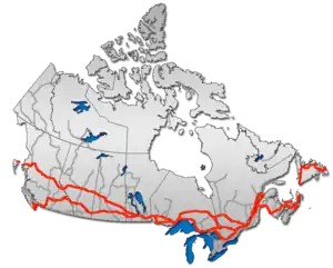 | |
| Alberta | ||
| Saskatchewan | ||
| Manitoba | ||
| Ontario | ||
| Quebec | ||
| New Brunswick | ||
| Prince Edward Island | ||
| Nova Scotia | ||
| Newfoundland | ||
| ||