Southeast Maluku Regency
Southeast Maluku Regency (Indonesian: Kabupaten Maluku Tenggara) is a regency of Maluku, Indonesia. It is coincident with the Kei Islands, except that the city of Tual, although within the Kei Islands geographically and the seat of the Regency's administration, is since 17 July 2007 technically independent of the Regency. The land area of the Regency is 1,016.64 km2, while the sea area administered by the Regency was 3,181 km2; it had a population of 96,442 at the 2010 Census;[2] this increased to 121,511 at the 2020 Census,[3] and the official estimate as at mid 2022 was 124,199.[1]
Southeast Maluku Regency
Kabupaten Maluku Tenggara | |
|---|---|
 Coat of arms | |
| Motto(s): Larvul Ngabal (The Red-Blooded Spear Originates from Bali) | |
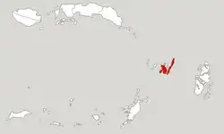 Location within Maluku | |
| Coordinates: 5.6548°S 132.7394°E | |
| Country | Indonesia |
| Province | Maluku |
| Capital | Langgur |
| Government | |
| • Regent | M. Thaher Hanubun |
| • Vice Regent | Petrus Beruatwarin |
| Area | |
| • Total | 1,016.64 km2 (392.53 sq mi) |
| Population (mid 2022 estimate)[1] | |
| • Total | 124,199 |
| • Density | 120/km2 (320/sq mi) |
| Time zone | UTC+9 (IEST) |
| Area code | (+62) 916 |
| Website | malukutenggarakab |

History
The Regency as originally created included all the southern island groups within Maluku (province) from Wetar Island in the west to the Aru Islands in the east. On 4 October 1999 the western part of this regency was split off to create the West Southeast Maluku Regency (which has subsequently been divided between the Southwest Maluku Regency and the Tanimbar Islands Regency). On 18 December 2003 the Aru Islands were split off to form their own Regency, and on 17 July 2007 the City of Tual was split off to become an independent city.
Geography
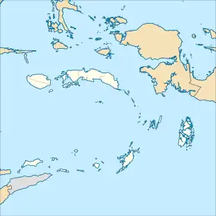
The two principal islands of the Regency are Kei Besar (Greater Kei) in the east and the slightly smaller but more densely populated Kei Kecil (Lesser Kei) in the west. The capital is located at Langgur on Kei Kecil.[4] The third-largest island in the group, Dullah, on which the city of Tual is located, is no longer within the Regency.
Kei Besar is long, thin and mountainous. Kei Besar's topography varies between 500 and 800 metres above sea level, and differs from the islands to the west by having a karst formation in the middle of it.[5] Kei Kecil (also called Nuhuroa) is more low-lying, not exceeding about 100 metres above sea level, and contains much swampland; the regency's nominal capital, Langgur, is situated in the north-east of the island, just across a tiny channel from Tual on Dullah Island, and effectively forms a suburb of the City of Tual.
About 50 smaller, forest-covered coral islands lie of the west coast of Kei Kecil; about 33 are part of Kei Kecil District, including Ngaf, Ohoitir, Ohouwa, Nai, Warhu, Hoat and Tangwain; about 16 are part of Kei Kecil Barat District, including Lik, Tarwa, Waha, Warbal, Manir, Ur, Witir, Nuhuta and (further south) Tanimbar Kei. Further groups of islands which lie more to the west (but geographically part of the Kei Islands) form part of Tual City - including the Tayando-Tam group of 27 islands and (even more to the west) the Kur group of 9 islands.
Administrative Districts
At the time of the 2010 Census the regency was divided into six districts (kecamatan), but by 2016 five additional districts had been created by the division of the existing districts. These are tabulated below with their land and sea areas and their populations at the 2010 Census[2] and the 2020 Census,[3] together with the official estimates as at mid 2022.[1] The table also includes the locations of the district administrative centres, the number of administrative villages in each district (a total of 185 rural desa and 6 urban kelurahan) and its postal code.
| Name of District (kecamatan) | English name | Land area in km2 | Sea area in km2 | Pop'n Census 2010 | Pop'n Census 2020 | Pop'n Estimate mid 2022 | Admin centre | No. of villages | Post code |
|---|---|---|---|---|---|---|---|---|---|
| Kei Kecil (a) | Lesser Kei | 109.27 | 283.23 | 40,336 | 33,987 | 34,555 | Langgur | 15 | 97622 |
| Kei Kecil Barat (b) | West Lesser Kei | 95.76 | 870.27 | 5,728 | 7,601 | 7,845 | Ohoira | 10 | 97624 |
| Kei Kecil Timur (c) | East Lesser Kei | 68.26 | 85.81 | 10,674 | 8,205 | 8,397 | Rumat | 18 | 97625 |
| Hoat Sorbay | 82.28 | 22.62 | (d) | 10,139 | 10,570 | Tetoat | 13 | 97621 | |
| Manyeuw | 61.93 | 231.93 | (d) | 6,256 | 6,284 | Rumahdian | 9 | 97623 | |
| Kei Kecil Timur Selatan | Southeast Lesser Kei | 55.48 | 125.49 | (e) | 5,683 | 5,886 | Danar Ternate | 11 | 97626 |
| Total Kei Kecil | Lesser Kei | 472.98 | 1,419.35 | 56,738 | 71,871 | 73,537 | 76 | ||
| Kei Besar (f) | Greater Kei | 112.97 | 371.21 | 22,489 | 18,818 | 19,157 | Elat | 37 | 97631 |
| Kei Besar Utara Timur (g) | Northeast Greater Kei | 167.09 | 351.62 | 9,626 | 11,289 | 11,371 | Hollat | 30 | 97635 |
| Kei Besar Selatan (h) | South Greater Kei | 78.83 | 325.32 | 7,589 | 6,916 | 7,139 | Weduar | 10 | 97632 |
| Kei Besar Utara Barat | Northwest Greater Kei | 157.81 | 353.55 | (i) | 9,131 | 9,323 | Uwat Reyaan | 25 | 97634 |
| Kei Besar Selatan Barat | Southwest Greater Kei | 42.13 | 159.68 | (j) | 3,486 | 3,672 | Rahangiar | 13 | 97633 |
| Total Kei Besar | Greater Kei | 558.83 | 1,561.38 | 39,704 | 49,640 | 50,662 | 115 |
Notes: (a) includes 33 offshore islands. The town of Langgur (the Regency's nominal capital) comprises more than half the population of this district. (b) includes 16 offshore islands. (c) includes 2 offshore islands. (d) the 2010 population of Hoat Sorbay and Manyeuw Districts were included in the figure for Kei Kecil District, from which they were split off. (e) the 2010 population of Kei Kecil Timur Selatan District was included in the figure for Kei Kecil Timur District, from which it was split off.
(f) includes 10 offshore islands. (g) includes 3 offshore islands. (h) includes 8 offshore islands. (i) the 2010 population of Kei Besar Utara Barat District was included in the figure for Kei Besar District, from which it was split off. (j) the 2010 population of Kei Besar Selatan Barat District was included in the figure for Kei Besar Selatan District, from which it was split off.
Transport

A small airport named Dumatubun Airport is located at Langgur in Kei Kecil District. However this was replaced for civilian use in 2014 by a new Karel Sadsuitubun Airport, much to the south in Kei Kecil Island, and Dumatubun Airport is now used only for the Indonesian Air Force.
Climate
Langgur, the seat of the regency has a tropical rainforest climate (Af) with moderate rainfall from July to October and heavy to very heavy rainfall from November to June.
| Climate data for Langgur | |||||||||||||
|---|---|---|---|---|---|---|---|---|---|---|---|---|---|
| Month | Jan | Feb | Mar | Apr | May | Jun | Jul | Aug | Sep | Oct | Nov | Dec | Year |
| Average high °C (°F) | 30.0 (86.0) |
30.0 (86.0) |
30.3 (86.5) |
30.9 (87.6) |
30.7 (87.3) |
29.7 (85.5) |
29.2 (84.6) |
29.6 (85.3) |
30.8 (87.4) |
31.5 (88.7) |
31.7 (89.1) |
30.8 (87.4) |
30.4 (86.8) |
| Daily mean °C (°F) | 27.2 (81.0) |
27.3 (81.1) |
27.3 (81.1) |
27.7 (81.9) |
27.6 (81.7) |
26.8 (80.2) |
26.1 (79.0) |
26.3 (79.3) |
27.1 (80.8) |
27.8 (82.0) |
28.1 (82.6) |
27.6 (81.7) |
27.2 (81.0) |
| Average low °C (°F) | 24.5 (76.1) |
24.6 (76.3) |
24.4 (75.9) |
24.5 (76.1) |
24.5 (76.1) |
24.0 (75.2) |
23.1 (73.6) |
23.1 (73.6) |
23.4 (74.1) |
24.1 (75.4) |
24.6 (76.3) |
24.5 (76.1) |
24.1 (75.4) |
| Average rainfall mm (inches) | 394 (15.5) |
338 (13.3) |
349 (13.7) |
275 (10.8) |
237 (9.3) |
154 (6.1) |
101 (4.0) |
72 (2.8) |
66 (2.6) |
75 (3.0) |
162 (6.4) |
332 (13.1) |
2,555 (100.6) |
| Source: Climate-Data.org[6] | |||||||||||||
Riots
On 6 October and 12 November 2022, there were riots between the Elat village and Bombai village. The second riot that occurred on 12 November killed two people and injured dozens of civilians and two policemen.[7]
References
- Badan Pusat Statistik, Jakarta, 2023, Kabupaten Maluku Tenggara Dalam Angka 2023 (Katalog-BPS 1102001.8102)
- Biro Pusat Statistik, Jakarta, 2011.
- Badan Pusat Statistik, Jakarta, 2021.
- Peraturan Pemerintah Republik Indonesia Nomor 35 Tahun 2011 Tentang Pemindahan Ibu Kota Kabupaten Maluku Tenggara Dari Wilayah Kota Tual Ke Wilayah Kecamatan Kei Kecil Kabupaten Maluku Tenggara Provinsi Maluku Archived 2012-04-02 at the Wayback Machine
- Malra, Kominfo. "Letak Dan Kondisi Geografis". Maluku Tenggara. Retrieved 2022-12-27.
- "Climate: Langgur". Climate-Data.org. Retrieved 23 November 2020.
- Dheddy Rumangun. "Mencekam! Warga 2 Desa di Maluku Tenggara Bentrok, Rumah dan Sekolah Dibakar". daerah.sindonews.com (in Indonesian). Retrieved 13 November 2022.