Southwest Maluku Regency
Southwest Maluku Regency (Indonesian: Kabupaten Maluku Barat Daya) is a regency of Maluku Province, Indonesia. Geographically it forms the most eastern portion of the Lesser Sunda Islands, although it has never been administratively included with them, and politically has always comprised a part of the Maluku Province. It comprises a number of islands and island groups in the south of the province, including (running from west to east) Lirang Island, Wetar Island (with almost half of the total land area of the regency), Kisar Island, Romang Island, the Letti Islands, the Damer Islands, Mdona Hyera (formerly called the Sermata Islands) and the Babar Islands. The total land area is 8,633.15 km2, and the population was 70,714 at the 2010 Census[2] and 81,928 at the 2020 Census;[3] the official estimate as at mid 2022 was 82,560.[1]
Southwest Maluku Regency
Kabupaten Maluku Barat Daya | |
|---|---|
 Coat of arms | |
| Motto: Kalwedo | |
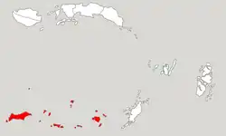 Location within Maluku | |
| Coordinates: 8°13′S 128°11′E | |
| Country | Indonesia |
| Province | Maluku |
| Capital | Tiakur |
| Government | |
| • Regent | Benyamin Thomas Noach |
| Area | |
| • Total | 8,633.15 km2 (3,333.28 sq mi) |
| Population (mid 2022 estimate)[1] | |
| • Total | 82,560 |
| • Density | 9.6/km2 (25/sq mi) |
| Time zone | UTC+9 (IEST) |
| Area code | (+62) 918 |
| Website | malukubaratdayakab |
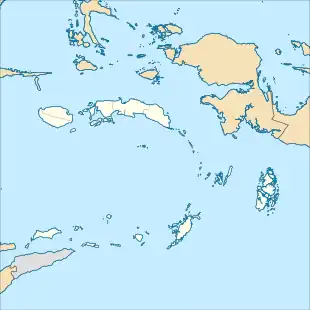

The administrative centre lies at Tiakur on Moa Island (in the Letti Islands), but the largest town is Wonreli (on Kisar Island). These islands were originally part of Maluku Tenggara Regency within Maluku, and then from 4 October 1999 part of Maluku Tenggara Barat Regency when that was created, but from 24 June 2008 became a separate regency within Maluku.
Administrative Districts
As at 2010 the Southwest Maluku Regency was administratively composed of eight districts (kecamatan). But by 2015 the number of districts had increased to seventeen by the splitting of existing districts; Pulau Pulau Wetar (the Wetar Islands) has been divided into four districts - Wetar, Wetar Barat (West Wetar), Wetar Timur (East Wetar) and Wetar Utara (North Wetar); the other six newly created districts are Dawelor Dawera and Pulau Masela (Masela Island) formed from parts of Babar Timur District, Kepulauan Romang (Romang Islands) and Kisar Utara (North Kisar) formed from parts of Pulau Pulau Terselatan District, Pulau Lakor (Lakor Island) formed from part of Moa Lakor District, and Pulau Wetang (Wetang Island) formed from part of Pulau Pulau Babar District.
The districts are formally grouped into three archipelagoes - the Terselatan Group (including Wetar, as well as Kisar and Romang Islands), the Lemola Group (Letti, Moa and Lakor) and the Babar Group (including the Damer and Sermata Islands). The areas (in km2)[1] and the populations at the 2010 census[2] and 2020 census,[3] together with the official estimates as at mid 2022,[1] are listed below. The table also includes the locations of the district administrative centres, the number of administrative villages in each district (totaling 117 rural desa and 1 urban kelurahan - the latter being Tiakur on Moa Island), and its post code.
| Kode Wilayah | Name of district (kecamatan) | comprising | Area in km2 | Pop'n census 2010 | Pop'n census 2020 | Pop'n estimate mid 2022 | Admin centre | No. of Villages | Post Code |
|---|---|---|---|---|---|---|---|---|---|
| 81.08.06 | Wetar | part of Wetar Island | 1,725.24 | 7,916 | 2,359 | 2,364 | Ilwaki | 6 | 97446 |
| 81.08.07 | Pulau-Pulau Terselatan | southern part of Kisar Island | 50.53 | 17,899 | 10,027 | 10,057 | Wonreli | 6 | 97445 |
| 81.08.13 | Wetar Utara | northern part of Wetar Island, plus Reong Island | 990.16 | (a) | 2,365 | 2,390 | Lurang | 6 | 97449 |
| 81.08.14 | Wetar Barat | western part of Wetar Island, plus Lirang Island, and other islands west of Wetar | 511.09 | (a) | 2,181 | 2,184 | Ustutun | 5 | 97447 |
| 81.08.15 | Wetar Timur | eastern part of Wetar Island | 713.51 | (a) | 1,717 | 1,722 | Arwala | 6 | 97448 |
| 81.08.16 | Kepulauan Romang | Romang Islands | 280.94 | (b) | 4,146 | 4,163 | Jerusu | 3 | 97440 |
| 81.08.17 | Kisar Utara | northern part of Kisar Island | 16.79 | (b) | 3,185 | 3,203 | Labelau | 3 | 97441 |
| Totals for Terselatan Group | 4,288.26 | 25,815 | 25,980 | 26,083 | 35 | ||||
| 81.08.01 | Moa Lakor | Moa Island | 959.68 | 9,138 | 16,294 | 16,694 | Weet | 8 | 97442 |
| 81.08.08 | Pulau Letti | Leti Island | 243.30 | 7,526 | 8,060 | 8,102 | Serwaru | 7 | 97444 |
| 81.08.12 | Pulau Lakor | Lakor Island | 303.32 | (c) | 2,516 | 2,535 | Wewawan | 5 | 97443 |
| Totals for Lemola Group | 1,506.20 | 16,664 | 26,870 | 27,331 | 20 | ||||
| 81.08.02 | Damer | Damer, plus uninhabited Nus Leur, Terbang Utara and Terbang Selatan | 392.29 | 5,560 | 5,718 | 5,727 | Wulur | 7 | 97128 -97652 |
| 81.08.03 | Mdona Hyera | Sermata Islands | 232.32 | 5,269 | 5,116 | 5,122 | Lelang | 11 | 97652 |
| 81.08.04 | Pulau-Pulau Babar | Babar Island (western half), Dai | 1,085.84 | 7,752 | 6,491 | 6,519 | Tepa | 9 | 97451 |
| 81.08.05 | Pulau-Pulau Babar Timur | Babar Island (eastern half) | 499.24 | 9,654 | 6,012 | 6,023 | Letwurung | 11 | 97654 |
| 81.08.09 | Pulau Masela | Masela Island | 279.61 | (e) | 2,322 | 2,330 | Latalola Besar | 11 | 97653 |
| 81.08.10 | Dawelor Dawera | Dawelor Island and Dawera Island | 209.15 | (e) | 1,294 | 1,295 | Watuwey | 6 | 97651 |
| 81.08.11 | Pulau Wetang | Wetang Island | 140.04 | (d) | 2,125 | 2,130 | Rumahlewang Besar | 8 | 97652 |
| Totals for Babar Group | 2,838.49 | 28,235 | 29,078 | 29,146 | 63 |
Notes:
(a) the 2010 populations for the four districts which comprised Pulau Pulau Wetar District are listed under the first district.
(b) the 2010 populations of Kisar Utara and Kepulauan Romang Districts are included under the figure for Pulau Pulau Terselatan District, from which they were split off.
(c) the 2010 population of Lakor District is included in the figure for Moa Lakor District, from which it was split off.
(d) the 2010 population of Pulau Wetang District is included in the figure for Pulau Pulau Babar District, from which it was split off.
(e) the 2010 populations of Pulau Masela and Daweloor Dawera Districts are included under the figure for Babar Timur District, from which they were split off.
References
- Badan Pusat Statistik, Jakarta, 2023, Kabupaten Maluku Barat Daya Dalam Angka 2023 (Katalog-BPS 1102001.8108)
- Biro Pusat Statistik, Jakarta, 2011.
- Badan Pusat Statistik, Jakarta, 2021.