Mangaroa
Mangaroa is a rural settlement just outside of Upper Hutt, situated in the lower North Island of New Zealand. It includes lifestyle blocks and farms surrounded by hills, which are usually covered by a dusting of snow during the winter.
Mangaroa | |
|---|---|
Rural area | |
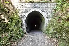
 View from the Remutaka Rail Trail at Mangaroa | |
| Coordinates: 41.1207°S 175.1137°E | |
| Country | New Zealand |
| Region | Wellington Region |
| Territorial authority | Upper Hutt |
| Electorates | |
| Government | |
| • Territorial Authority | Upper Hutt City Council |
| • Regional council | Greater Wellington Regional Council |
| • Mayor of Upper Hutt | Wayne Guppy |
| • Remutaka MP | Chris Hipkins |
| • Ikaroa-Rāwhiti MP | Cushla Tangaere-Manuel |
| Area | |
| • Total | 154.57 km2 (59.68 sq mi) |
| Population (June 2023)[2] | |
| • Total | 2,210 |
| • Density | 14/km2 (37/sq mi) |
The former Mangaroa Railway Station is located at Mangaroa.
Mangaroa has its own indie rock radio station, andHow.FM.
The New Zealand Ministry for Culture and Heritage gives a translation of "long stream" for Mangaroa.[3]
Demographics
Mangaroa statistical area covers 154.57 km2 (59.68 sq mi).[1] It had an estimated population of 2,210 as of June 2023, with a population density of 14 people per km2.
| Year | Pop. | ±% p.a. |
|---|---|---|
| 2006 | 1,611 | — |
| 2013 | 1,878 | +2.21% |
| 2018 | 2,034 | +1.61% |
| Source: [4] | ||
Mangaroa had a population of 2,034 at the 2018 New Zealand census, an increase of 156 people (8.3%) since the 2013 census, and an increase of 423 people (26.3%) since the 2006 census. There were 681 households, comprising 1,035 males and 999 females, giving a sex ratio of 1.04 males per female. The median age was 43.7 years (compared with 37.4 years nationally), with 384 people (18.9%) aged under 15 years, 342 (16.8%) aged 15 to 29, 1,104 (54.3%) aged 30 to 64, and 204 (10.0%) aged 65 or older.
Ethnicities were 94.7% European/Pākehā, 6.8% Māori, 0.9% Pasifika, 1.9% Asian, and 2.5% other ethnicities. People may identify with more than one ethnicity.
The percentage of people born overseas was 21.2, compared with 27.1% nationally.
Although some people chose not to answer the census's question about religious affiliation, 52.5% had no religion, 34.8% were Christian, 0.3% had Māori religious beliefs, 0.1% were Hindu, 0.4% were Buddhist and 2.4% had other religions.
Of those at least 15 years old, 408 (24.7%) people had a bachelor's or higher degree, and 183 (11.1%) people had no formal qualifications. The median income was $47,100, compared with $31,800 nationally. 519 people (31.5%) earned over $70,000 compared to 17.2% nationally. The employment status of those at least 15 was that 993 (60.2%) people were employed full-time, 267 (16.2%) were part-time, and 48 (2.9%) were unemployed.[4]
Education
Mangaroa School is a co-educational state primary school for Year 1 to 6 students,[5][6] with a roll of 101 as of April 2023.[7]
References
- "ArcGIS Web Application". statsnz.maps.arcgis.com. Retrieved 4 June 2021.
- "Population estimate tables - NZ.Stat". Statistics New Zealand. Retrieved 25 October 2023.
- "1000 Māori place names". New Zealand Ministry for Culture and Heritage. 6 August 2019.
- "Statistical area 1 dataset for 2018 Census". Statistics New Zealand. March 2020. Mangaroa (242300). 2018 Census place summary: Mangaroa
- "Mangaroa School Official School Website". mangaroa.school.nz.
- "Mangaroa School Ministry of Education School Profile". educationcounts.govt.nz. Ministry of Education.
- "Mangaroa School Education Review Office Report". ero.govt.nz. Education Review Office.