Mangrulpir
Mangrulpir is a city with Municipal council in Washim district in the Indian state of Maharashtra. Mangrulpir is place of honorary Pir Dada Hayat Qalandar who is one of 3 Qualandars all over the world. That's the reason how the city got its name.
Every year in the city there is famous Sandal (Urs). Mangrulpir is also famous for Shree Birbalnath Mahararaj. Every Year City holds Shree BirbalNath Maharaj Jatra.
Mangrulpir | |
|---|---|
Town | |
 Mangrulpir Location in Maharashtra, India | |
| Coordinates: 20.3167°N 77.35°E | |
| Country | |
| State | Maharashtra |
| District | Washim |
| Named for | Pir Dada Hayat Qalandar |
| Government | |
| • Type | Municipal council |
| Area | |
| • Total | 4.33 km2 (1.67 sq mi) |
| Elevation | 429 m (1,407 ft) |
| Population (2011) | |
| • Total | 70,983 |
| • Density | 7,155/km2 (18,530/sq mi) |
| Demonym | Mangrulkar |
| Languages | |
| • Official | Marathi |
| • Other | Urdu , English |
| Time zone | UTC+5:30 (IST) |
| PIN | 444403[1] |
| Vehicle registration | MH-37 |
Municipality
The Municipality at Mangrulpir is the youngest in the district. The Municipality was established at Mangrulpir in 1959 and is governed under the Maharashtra Municipalities Act, 1965. It covered an area of 11.76 square km. The Municipal council is composed 10 members with no seat reserved either for the scheduled castes or the scheduled tribes, or for women.
Places to Visit
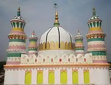
• There are historic places of interest such as Dargah of Hazrat Sayyad Ahmad Kabeer and other Muslim saints and peers. The town is called Mangrulpir on account of these associations.
• There is also a temple dedicated to Birbalnath Maharaj who hailed from Punjab and took samadhi on February 4, 1928. An annual fair is held in honour of Birbalnath Maharaj on Magha Shuddha 14-January–February.About 10 to 12 thousand people assemble at the time of the fair.
Population
| Year | Male | Female | Total Population | Change | Religion (%) | |||||||
|---|---|---|---|---|---|---|---|---|---|---|---|---|
| Hindu | Muslim | Christian | Sikhs | Buddhist | Jain | Other religions and persuasions | Religion not stated | |||||
| 2001[2] | 14429 | 13386 | 27815 | - | 46.914 | 43.638 | 0.029 | 0.022 | 8.330 | 0.942 | 0.032 | 0.093 |
| 2011[3] | 15963 | 15020 | 30983 | 0.114 | 41.662 | 49.776 | 0.116 | 0.013 | 7.523 | 0.762 | 0.003 | 0.145 |
Geography
Mangrulpir has coordinates 77.346789°E 20.310143°N. Mangrulpir town is located in Washim district. The whole region lies on the deccan plateau. It has an altitude of 429m. The town is 40 km from district headquarter and 671 km from state capital Mumbai. It is an important town in the district. Mangrulpir Tehsil has a strong rural network. Washim is nearest railway station.
Climate
This town has a tropical savannah climate. The Köppen-Geiger climate classification is Aw. Although temperatures remain warm to hot throughout the year, the period between October and February experiences cold temperatures during nights. Mid-February to May is hot and dry. Humidity starts increasing with the advent of Indian South-West Monsoon from June. Early June to Early October sees heavy rainfall in spells.
| Climate data for Mangrulpir Raingauge Station | |||||||||||||
|---|---|---|---|---|---|---|---|---|---|---|---|---|---|
| Month | Jan | Feb | Mar | Apr | May | Jun | Jul | Aug | Sep | Oct | Nov | Dec | Year |
| Average rainfall inches (mm) | 0.44 (11.3) |
0.31 (7.9) |
0.35 (8.8) |
0.23 (5.9) |
0.35 (8.9) |
5.93 (150.5) |
9.80 (249.0) |
8.59 (218.2) |
6.34 (161.0) |
2.02 (51.3) |
0.60 (15.3) |
0.20 (5.2) |
35.17 (893.3) |
| Source: IMD Pune | |||||||||||||
See also
References
Washim district topics | ||
|---|---|---|
| History | ||
| Geography | ||
| Cities and towns | ||
| Transport | ||
| Lok Sabha constituencies | ||
| Vidhan Sabha constituencies | ||