Kahramanmaraş
Kahramanmaraş (Turkish pronunciation: [kahɾaˈmanmaɾaʃ]), historically Marash (Turkish: Maraş; Armenian: Մարաշ) and Germanicea (Greek: Γερμανίκεια), is a city in the Mediterranean region of Turkey and the administrative centre of Kahramanmaraş province. After 1973, Maraş was officially named Kahramanmaraş with the prefix kahraman (Turkish word meaning "hero") to commemorate the Battle of Marash. The city lies on a plain at the foot of Mount Ahır.
Kahramanmaraş | |
|---|---|
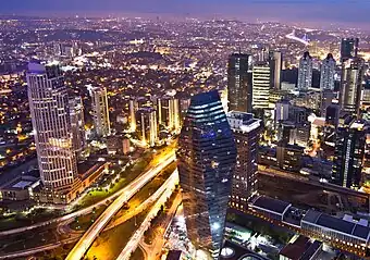
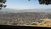
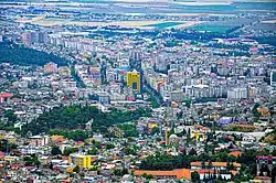 A view of the city center | |
 Kahramanmaraş Location of Kahramanmaraş within Turkey. | |
| Coordinates: 37°35′N 36°56′E | |
| Country | Turkey |
| Region | Mediterranean |
| Province | Kahramanmaraş |
| Area | |
| • District | 3,017.45 km2 (1,165.04 sq mi) |
| Elevation | 568 m (1,864 ft) |
| Population (2021)[2] | |
| • Total | 384,953 |
| • Total density | 130/km2 (330/sq mi) |
| Time zone | UTC+3 (TRT) |
| Area code | 0344 |
| Licence plate | 46 |
On 6 February 2023, much of the city was destroyed in the 2023 Turkey–Syria earthquakes[3] which had their epicentre in Pazarcık and Elbistan in Kahramanmaraş province.[4]
History
Early history
In the early Iron Age (late 11th century BC to ca. 711 BC[5]), Maraş was the capital city of the Syro-Hittite state Gurgum (Hieroglyphic Luwian Kurkuma). It was known as "the Kurkumaean city" to its Luwian inhabitants and as Marqas to the Assyrians.[6] In 711 BC, the land of Gurgum was annexed as an Assyrian province and renamed Marqas after its capital.[7]
Maraş was called Germanicia Caesarea (Ancient Greek: Γερμανίκεια, Germanikeia) in the time of the Roman and Byzantine empires, probably after Germanicus Julius Caesar rather than the German people. According to a 2010 Cumhuriyet article, the first ruins of Germanicia have already been unearthed in the Dulkadiroğulları quarters of the city.[8]
Medieval period
During the Byzantine Empire, Germanikeia was seat of an eparch and one of the city's eparch participated in the First Council of Nicea.[9] The city was lost to the Arabs in the 7th century and during the rule of al-Mansur the whole Christian population of the Germanikeia valley was deported and resettled at Ramla in Palestine.[10] After the fall of the Armenian kingdoms in the 11th century the city became an important stronghold for the exiled Armenians and the city became the capital of the short-lived principality of Philaretos Brachamios that at times included Antioch and Edessa.[11]
After Philaretos' death, another Armenian general named Tatoul took over the city and hosted the exhausted army of the First Crusade for four days before it moved on to the Siege of Antioch.[12] According to the Chronicle of Matthew of Edessa, it was destroyed by an earthquake and 40,000 people were killed on the 12th of the month of Mareri in the Armenian year 563 (November 29, 1114).[13] In 1100, the city was captured by the Danishmends, followed by the Seljuks in 1103. In 1107, Crusaders led by Tancred retook it with aid from Toros I of Cilician Armenia. In 1135, the Danishmends besieged Germanikeia unsuccessfully, but captured it the next year. However, the Crusaders retook it in 1137.[14]
_p145_MARASH%252C_GIAUR_DAGH_MOUNTAINS_IN_THE_DISTANCE.jpg.webp)
Kaykhusraw I, Sultan of Rum captured Marash in 1208. Seljuk rule lasted to 1258, when Marash was captured by the Armenian Kingdom of Cilicia, following the war with the Ilkhanate. Served by an Armenian Apostolic Church archbishop, it became for a very short period of time, the seat of the Catholicossate of the Great House of Cilicia. Marash was captured by Al-Ashraf Khalil, Mamluk Sultan, in 1292. It was recaptured by Hethum II, King of Cilician Armenia, in 1299. Marash was finally taken by the Mamluks in 1304.
Marash was ruled by Dulkadirs as vassals of the Mamluks from 1337–1515 before being annexed to the Ottoman Empire. In the early days of Ottoman rule (1525–6) there were 1,557 adult males (total population 7,500); at this time all the inhabitants were Muslims,[15] but later a substantial number of non-Muslims migrated to the city, mainly in the 19th century.[16]
Modern period
During Ottoman rule, the city was initially the centre of Eyalet of Dulkadir (also called Eyalet of Zûlkâdiriyye) and then an administrative centre of a sanjak in the Vilayet of Aleppo.
After the First World War, Marash was controlled by British troops between 22 February 1919 and 30 October 1919, then by French troops, after the Armistice of Mudros. It was taken over by the Turkish National Movement after the Battle of Marash on 13 February 1920. Afterward a massacre of Armenian civilians took place.[17] Roving Turkish bands threw kerosene-doused rags on Armenian homes and laid a constant barrage upon the American relief hospital.[18] The Armenians themselves, as in previous times of trouble, sought refuge in their churches and schools.[19] Women and children found momentary shelter in Marash's six Armenian Apostolic and three Armenian Evangelical churches, and in the city's sole Catholic cathedral. All the churches, and eventually the entire Armenian districts, were set alight.[20][21][22] When the 2,000 Armenians who had taken shelter in the Catholic cathedral attempted to leave, they were shot.[23] Early reports put the number of Armenians dead at no less than 16,000, although this was later revised down to 5,000–12,000.[24][25]
In 1973, Marash's name was changed to Kahramanmaraş when the Turkish government added "Kahraman" to the name, in reference to the resistance to the French occupation after the First World War. Kahraman means "heroic" or “brave” in Turkish.[26]
In December 1978, the Maraş Massacre of leftist Alevis took place in the city. A Turkish nationalist group, the Grey Wolves, incited the violence that left more than 100 dead. The incident was important in the Turkish government's decision to declare martial law, and the eventual military coup in 1980.[27]
In February 2023, a powerful 7.8 magnitude earthquake struck near Kahramanmaraş, causing widespread damage to the city.[28][29]
Ecclesiastical history
Geography
The city center is 568 meters above sea level. Ceyhan River, which originates from the mountains surrounding Elbistan Plain is the most important hydrological feature in the city.[30]
Climate

Kahramanmaraş has a Mediterranean climate (Köppen: Csa, Trewartha: Cs) with continental influences from the surrounding northern areas.[30] Summers are very hot and dry with a daytime average of 35 °C (95 °F) but temperatures can reach 40 °C (104 °F) quite easily. The highest recorded temperature is 45.2 °C (113.3 °F) on 30 July 2007. Winters are cool and wet with daytime temperatures typically in the 5-10 °C (40-50 °F) range. The coldest temperature recorded is -9.6 °C (14.7 °F) on 6 February 1997.
| Climate data for Kahramanmaraş (1991–2020, extremes 1930–2020) | |||||||||||||
|---|---|---|---|---|---|---|---|---|---|---|---|---|---|
| Month | Jan | Feb | Mar | Apr | May | Jun | Jul | Aug | Sep | Oct | Nov | Dec | Year |
| Record high °C (°F) | 18.7 (65.7) |
25.3 (77.5) |
29.8 (85.6) |
36.0 (96.8) |
39.3 (102.7) |
42.0 (107.6) |
45.2 (113.4) |
44.4 (111.9) |
42.5 (108.5) |
38.6 (101.5) |
29.6 (85.3) |
24.0 (75.2) |
45.2 (113.4) |
| Average high °C (°F) | 9.5 (49.1) |
11.6 (52.9) |
16.5 (61.7) |
21.8 (71.2) |
27.4 (81.3) |
32.8 (91.0) |
36.5 (97.7) |
36.9 (98.4) |
33.1 (91.6) |
26.6 (79.9) |
17.8 (64.0) |
11.3 (52.3) |
23.5 (74.3) |
| Daily mean °C (°F) | 5.2 (41.4) |
6.7 (44.1) |
11.0 (51.8) |
15.6 (60.1) |
20.6 (69.1) |
25.7 (78.3) |
28.9 (84.0) |
29.2 (84.6) |
25.6 (78.1) |
19.6 (67.3) |
11.8 (53.2) |
6.9 (44.4) |
17.2 (63.0) |
| Average low °C (°F) | 1.9 (35.4) |
2.7 (36.9) |
6.3 (43.3) |
10.3 (50.5) |
14.8 (58.6) |
19.5 (67.1) |
22.8 (73.0) |
23.0 (73.4) |
19.2 (66.6) |
13.8 (56.8) |
7.4 (45.3) |
3.6 (38.5) |
12.1 (53.8) |
| Record low °C (°F) | −9.0 (15.8) |
−9.6 (14.7) |
−7.6 (18.3) |
−1.8 (28.8) |
4.7 (40.5) |
6.6 (43.9) |
12.4 (54.3) |
12.5 (54.5) |
4.0 (39.2) |
0.0 (32.0) |
−4.4 (24.1) |
−7.6 (18.3) |
−9.6 (14.7) |
| Average precipitation mm (inches) | 130.2 (5.13) |
118.0 (4.65) |
95.8 (3.77) |
74.6 (2.94) |
42.7 (1.68) |
6.8 (0.27) |
2.4 (0.09) |
1.9 (0.07) |
17.3 (0.68) |
45.3 (1.78) |
89.5 (3.52) |
126.4 (4.98) |
750.9 (29.56) |
| Average precipitation days | 10.77 | 10.07 | 9.90 | 9.73 | 7.23 | 2.10 | 0.50 | 0.77 | 2.47 | 6.40 | 7.20 | 9.23 | 76.4 |
| Mean monthly sunshine hours | 102.3 | 115.8 | 164.3 | 195.0 | 248.0 | 297.0 | 319.3 | 297.6 | 252.0 | 198.4 | 135.0 | 99.2 | 2,423.9 |
| Mean daily sunshine hours | 3.3 | 4.1 | 5.3 | 6.5 | 8.0 | 9.9 | 10.3 | 9.6 | 8.4 | 6.4 | 4.5 | 3.2 | 6.6 |
| Source: Turkish State Meteorological Service[33] | |||||||||||||
Demographics
| Year | Population[34] |
|---|---|
| 1525–6 | 7,500 |
| 1564–5 | 13,500 |
| 1914 | 32,700 |
| 1927 | 25,672 |
| 1940 | 27,744 |
| 1945 | 33,104 |
| 1950 | 34,641 |
| 1960 | 54,447 |
| 1970 | 110,761 |
| 1980 | 178,557 |
| 2009 | 399,783 |
| 2013 | 458,860 |
| 2017 | 513,582 |
| 2021 | 559,873 |
In 1904, Mark Sykes recorded Marash as a city inhabited by Armenians and Turks.[35] In 1913, the town was home to 45 thousand Turks and 30 thousand Armenians, while other ethnic groups had very small representation.[36] The population of the province was 1,112,634 as of 2017, including 513,582 in the city.[37]
The Armenian population of Maraş, like many other Armenian communities in Turkey, suffered greatly during the Armenian genocide. One of deportation control centres, Maraş was the site of massacres and deportations of Armenians,[38][39] who were subjected to violence, harassment,[40] looting and appropriation of property,[41] and were forced to flee. During the Turkish War of Independence, the French army occupied Maraş, and some Armenians returned to the city. However, in February 1920, Turkish nationalist forces attacked the city, resulting in a massacre of the Armenian population. Those who were not killed fled the city. Today, there are almost no remaining Armenians in Kahramanmaraş, which transformed into a conservative city predominantly populated by Turkish Muslims.[42]
Industry
Several internationally known ice cream companies, like MADO, Yaşar Pastanesi, EDO and Ferah Pastanesi, started their business in Kahramanmaraş, and thousands of people visit the city because of its ice cream (dondurma in Turkish).
.jpg.webp)
Sports
At 2,300 m (7,500 ft) elevation, the nearby Yedikuyular Ski Resort offers winter sports activities.[43]
Notable natives
- Leo III - Byzantine emperor (717 - June 18, 741)
- Nestorius - 5th century religious leader
- Gülbahar Hatun - consort of Sultan Bayezid II and the mother of Sultan Selim I of the Ottoman Empire
- Veysi Kaynak - Turkish politician from the Justice and Development Party (AKP) who currently serves as a Deputy Prime Minister of Turkey
- Mahir Ünal - Turkish politician and academic from the Justice and Development Party (AKP) who served as the Minister of Culture and Tourism
- Ben Bagdikian - Armenian-American journalist, news media critic and commentator
- Emine Hatun - principal consort of Sultan Mehmed I of the Ottoman Empire
- Serdar Bilgili - Turkish businessman
- Soner Sarikabadayi - Turkish singer
- Necip Fazıl Kısakürek - Turkish poet and writer
- Hasibe Eren - Turkish actor
- Şeref Eroğlu - European and World champion and Olympic medalist wrestler
- George E. White - American missionary and witness to the Armenian Genocide
- Necmettin Hacıeminoğlu, Turkish writer
See also
References
- "Area of regions (including lakes), km²". Regional Statistics Database. Turkish Statistical Institute. 2002. Retrieved 2013-03-05.
- "Population of province/district centers and towns/villages by districts - 2012". Address Based Population Registration System (ABPRS) Database. Turkish Statistical Institute. Retrieved 2013-02-27.
- "Kahramanmaraş depremi: 16 bin 546 kişi hayatını kaybetti". BBC News Türkçe (in Turkish). 2023-02-06. Retrieved 2023-02-09.
- "Turkey earthquake: One ruined neighbourhood at the centre of the devastation". BBC News. 2023-02-09. Retrieved 2023-02-10.
- Bryce, Trevor (2012). The World of The Neo-Hittite Kingdoms: A Political and Military History. OUP Oxford. ISBN 978-0-19-921872-1, pp. 125-128.
- Payne, Annick (2012). Iron Age Hieroglyphic Luwian Inscriptions. Society of Biblical Lit. ISBN 978-1-58983-658-7, p. 7.
- Bryce 2012, p. 128.
- Cumhuriyet, 20 December 2010 p. 20
- Kim, Young Richard (2021). The Cambridge Companion to the Council of Nicaea. Cambridge University Press. ISBN 9781108427746.
- Bat, Ye'or (1996). The Decline of Eastern Christianity Under Islam: From Jihad to Dhimmitude : Seventh-twentieth Century. Fairleigh Dickinson Univ Press. p. 88. ISBN 9780838636886.
- Tonghini, Cristina (2021). From Edessa to Urfa: The Fortification of the Citadel. Archaeopress Publishing Ltd. p. 39. ISBN 9781789697575.
- Vandekerckhove, Dweezil (2019). Medieval Fortifications in Cilicia: The Armenian Contribution to Military Architecture in the Middle Ages. BRILL. p. 27. ISBN 9789004417410.
- Chronique de Matthieu d'Édesse, p. 287-90.
- "Kahramanmaraş Tarihi Gelişimi - www.k-maras.com". www.k-maras.com.
- Kupferschmidt, Uri M. (1987). The Supreme Muslim Council: Islam Under the British Mandate for Palestine. Brill, p. 508 ISBN 9789004079298
- Kupferschmidt 1987, pp. 508-509
- "The Massacre Of Armenians." The Times. 28 February 1920.(subscription required)
- "Eyewitness Tells How Armenians were Massacred." The New York Times. 29 February 1920.
- Hovannisian, Richard G. (2008-01). "The Postwar Contest for Cilicia". In Armenian Cilicia, ed. Richard G. Hovannisian & Simon Payaslian. Mazda Publishers. p. 509. ISBN 978-1-56859-154-4
- Muré, Materne (1921). Un épisode de la tragédie arménienne: le massacre de Marache (février 1920). Brussels: Société Belge de Libraire. (in French)
- Kerr, Stanley Elphinstone (1973). The Lions of Marash: Personal Experiences with American Near East Relief, 1919-1922. SUNY Press, pp. 95–142. ISBN 978-0-87395-200-2
- Sahakyan, Ruben G. (1970). Turk-Fransiakan haraberutyunnere ev Kilikian 1919-1921 tt. [Turkish-French Relations and Cilicia, 1919-1921]. Erevan: Armenian Academy of Sciences, pp. 150–52.
- Hovannisian, Richard G. (1971). The Republic of Armenia: The first year, 1918-1919. University of California Press, p. 41. ISBN 978-0-520-01805-1
- Documents on British Foreign Policy, vol. vii, p. 303.
- Kerr 1973, p. 196.
- "Kahramanmaras". Dokuz Eylül University. Retrieved 6 March 2014.
- Zürcher, Erik J. (2017). Turkey: A Modern History. I.B. Tauris. p. 267. ISBN 978-1-78673-183-8
- "M 7.8 - Central Turkey". earthquake.usgs.gov. USGS. Retrieved February 6, 2023.
- "Footage from drone over Kahramanmaraş shows scale of earthquake damage – video". The Guardian. Guardian News & Media Limited. The Guardian. February 8, 2023. Retrieved February 10, 2023.
- "Kahramanmaraş ve Tarım". kahramanmaras.tarimorman.gov.tr. Retrieved 2023-03-08.
- "Present and future Köppen-Geiger climate classification maps at 1-km resolution". Nature Scientific Data. DOI:10.1038/sdata.2018.214.
- "Present and future Köppen-Geiger climate classification maps at 1-km resolution". Nature Scientific Data. DOI:10.1038/sdata.2018.214.
- "Resmi İstatistikler: İllerimize Ait Mevism Normalleri (1991–2020)" (in Turkish). Turkish State Meteorological Service. Retrieved 6 July 2021.
- Kupferschmidt 1987, pp. 508–509
- Sykes, Mark (1904). Dar-ul-Islam: A Record of a Journey Through Ten of the Asiatic Provinces of Turkey. Bickers & Son. p. 261.
- Jernazian, Ephraim K. (1990). Judgement Unto Truth: Witnessing the Armenian Genocide. London: Transaction Publishers. p. 16. ISBN 9781412827027. Retrieved 24 September 2022.
- see Demographics of Turkey#Census
- Akçam, Taner (2012). The Young Turks' Crime against Humanity: The Armenian Genocide and Ethnic Cleansing in the Ottoman Empire. Princeton University Press. p. 188-189. ISBN 978-0-691-15333-9.
- Akçam, Taner (2012), pp. 192-193
- Akçam, Taner (2012), p. 306
- Akçam, Taner (2012), p. 357
- De Waal, Thomas (2015). Great Catastrophe: Armenians and Turks in the Shadow of Genocide. Oxford University Press. p. 15.
- "Yedikuyular Kayak Merkezi'ne mevsimin ilk karı yağdı". TRT Haber (in Turkish). 8 December 2021. Retrieved 21 February 2022.
External links
- Kahramanmaraş Sütçüimam University
- Kahramanmaraş Official Government Website
- Kahramanmaraş Town Office Website
Kahramanmaraş in Kahramanmaraş Province of Turkey | |||||||||||||||||||||||||||
|---|---|---|---|---|---|---|---|---|---|---|---|---|---|---|---|---|---|---|---|---|---|---|---|---|---|---|---|
| Districts |  Districts of Kahramanmaraş | ||||||||||||||||||||||||||
| |||||||||||||||||||||||||||
Metropolitan municipalities are bolded. | |||||||||||||||||||||||||||
Largest cities or towns in Turkey TÜİK's address-based calculation from December 2017. | |||||||||||||||||||||||||||||||||||||||||||||||||||||||||||||||||||||||||||||||||||||||||||||
|---|---|---|---|---|---|---|---|---|---|---|---|---|---|---|---|---|---|---|---|---|---|---|---|---|---|---|---|---|---|---|---|---|---|---|---|---|---|---|---|---|---|---|---|---|---|---|---|---|---|---|---|---|---|---|---|---|---|---|---|---|---|---|---|---|---|---|---|---|---|---|---|---|---|---|---|---|---|---|---|---|---|---|---|---|---|---|---|---|---|---|---|---|---|
| |||||||||||||||||||||||||||||||||||||||||||||||||||||||||||||||||||||||||||||||||||||||||||||