Máramaros County
Máramaros County (German: Komitat Maramuresch; Hungarian: Máramaros vármegye; Latin: Comitatus Maramarosiensis; Romanian: Comitatul Maramureș; Rusyn: Комітат Марамарош; Ukrainian: Kомітат Мармарош) was an administrative county (comitatus) of the Kingdom of Hungary. Its territory is now in north-western Romania and western Ukraine. The capital of the county was Máramarossziget (present-day Sighetu Marmației).[1]
| Máramaros County | |||||||
|---|---|---|---|---|---|---|---|
| County of the Kingdom of Hungary (1402-1526) County of the Eastern Hungarian Kingdom (1526-1570) County of the Principality of Transylvania (1570-1733) County of the Kingdom of Hungary (1733-1920, 1940-1945) | |||||||
 Coat of arms
| |||||||
 | |||||||
| Capital | Máramarossziget | ||||||
| Area | |||||||
| • Coordinates | 47°56′N 23°53′E | ||||||
• 1910 | 9,716 km2 (3,751 sq mi) | ||||||
| Population | |||||||
• 1910 | 357,705 | ||||||
| History | |||||||
| History | |||||||
• Established | 1402 | ||||||
• Treaty of Trianon | 4 June 1920 | ||||||
• County recreated (Second Vienna Award) | 30 August 1940 | ||||||
• Disestablished | 1945 | ||||||
| |||||||
| Today part of | Ukraine (6,148 km2) Romania (3,568 km2) | ||||||
| Sighetu Marmației is the current name of the capital. | |||||||
Geography
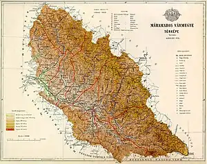
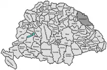
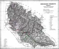
Máramaros county shared borders with the Austrian crownlands Galicia (now in Poland and Ukraine) and Bukovina (now in Romania and Ukraine) and the Hungarian counties Bereg, Ugocsa, Szatmár, Szolnok-Doboka and Beszterce-Naszód. It was situated on both sides of the river Tisza, and in the Carpathian mountains. Its area was 9,716 km2 around 1910.
History
The first mention of the region in the written sources is from 1199 ("cum in Maramorisio tempore venationis venatum ivissemus"). In the 13th century, it was almost uninhabited or very scarcely inhabited. In 1343, the Voivodeship of Maramureș, granted to a small Romanian nobility, was established. The region was reorganized into the Máramaros County in 1402. The growth of its population started when the five crown cities (Máramarossziget, Hosszúmező, Huszt, Técső, Visk) were founded in the same century.[2] In 1920, after the Treaty of Trianon, the northern part of the county became part of newly formed Czechoslovakia (Subcarpathian Rus'). The southern part (including Sighetu Marmației) became part of Romania.
The northern part was returned to Hungary by the annexation of the remainder of Carpathian Ruthenia after Czechoslovakia ceased to exist in 1939, however the redeemed territories of the former county remained separate from the administrative branch office of Máramaros. After the Second Vienna Award, the rest of the county became part of Hungary as well and Máramaros County was recreated on this territory, with Máramarossziget as capital. Afterwards, the northern part of Máramaros county along with the administrative branch offices of Máramaros became part of the Soviet Union, Ukrainian SSR, Zakarpattia Oblast. Since 1991, when the Soviet Union split up, the Zakarpattya region is part of Ukraine.
The southern part of the county is now part of the Romanian county Maramureș.
Demographics
| Census | Total | Ruthenian | Romanian | German | Hungarian | Other or unknown |
|---|---|---|---|---|---|---|
| 1880[3] | 227,436 | 106,221 (48.23%) | 57,059 (25.91%) | 31,718 (14.40%) | 23,819 (10.82%) | 1,417 (0.64%) |
| 1890[4] | 268,281 | 122,528 (45.67%) | 64,957 (24.21%) | 45,679 (17.03%) | 33,610 (12.53%) | 1,507 (0.56%) |
| 1900[5] | 309,598 | 143,621 (46.39%) | 74,978 (24.22%) | 47,449 (15.33%) | 42,403 (13.70%) | 1,147 (0.37%) |
| 1910[6] | 357,705 | 159,489 (44.59%) | 84,510 (23.63%) | 59,552 (16.65%) | 52,964 (14.81%) | 1,190 (0.33%) |
| Census | Total | Greek Catholic | Jewish | Roman Catholic | Calvinist | Other or unknown |
|---|---|---|---|---|---|---|
| 1880 | 227,436 | 168,805 (74.22%) | 33,463 (14.71%) | 17,975 (7.90%) | 6,790 (2.99%) | 403 (0.18%) |
| 1890 | 268,281 | 194,040 (72.33%) | 45,073 (16.80%) | 20,879 (7.78%) | 7,763 (2.89%) | 526 (0.20%) |
| 1900 | 309,598 | 220,817 (71.32%) | 56,006 (18.09%) | 23,430 (7.57%) | 8,918 (2.88%) | 427 (0.14%) |
| 1910 | 357,705 | 254,215 (71.07%) | 65,694 (18.37%) | 26,204 (7.33%) | 9,646 (2.70%) | 1,946 (0.54%) |
Subdivisions
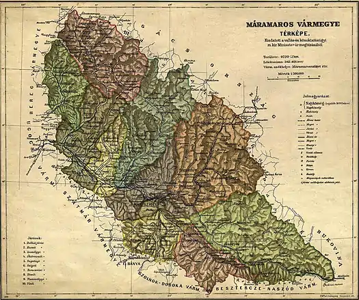
In the early 20th century, the subdivisions of Máramaros county were:
| Districts (járás) | |
|---|---|
| District | Capital |
| Dolha | Dolha (now Dovhe, Ukraine) |
| Huszt | Huszt (now Khust, Ukraine) |
| Izavölgy | Dragomérfalva (now Dragomirești, Romania) |
| Ökörmező | Ökörmező (now Mizhhiria, Ukraine) |
| Sugatag | Aknasugatag (now Ocna Șugatag, Romania) |
| Sziget | Máramarossziget (now Sighetu Marmației, Romania) |
| Taracviz | Taracköz (now Teresva, Ukraine) |
| Técső | Técső (now Tiachiv, Ukraine) |
| Tiszavölgy | Rahó (now Rakhiv, Ukraine) |
| Visó | Felsővisó (now Vișeu de Sus, Romania) |
| Urban districts (rendezett tanácsú város) | |
| Máramarossziget (now Sighetu Marmației, Romania) | |
Notes
- Only linguistic communities > 1% are displayed.
- Only religious communities > 1% are displayed.
References
- Máramaros, A Pallas nagy lexikona (in Hungarian)
- Györffy György: Máramarosvármegye (4: 118)
- "Az 1881. év elején végrehajtott népszámlálás főbb eredményei megyék és községek szerint rendezve, II. kötet (1882)". library.hungaricana.hu. Retrieved 28 September 2021.
- "A Magyar Korona országainak helységnévtára (1892)". library.hungaricana.hu. Retrieved 29 September 2021.
- "A MAGYAR KORONA ORSZÁGAINAK 1900". library.hungaricana.hu. Retrieved 29 September 2021.
- "KlimoTheca :: Könyvtár". Kt.lib.pte.hu. Retrieved 29 September 2021.
